Second Phase, Short- and Longlisted Entries
Author
FRPO Rodriguez & Oriol
Location: Madrid
www.frpo.es
Team: Pablo Oriol Salgado, Architekt ETSAM, COAM 15216; Adrian Sànchez, Ricardo Gonzaléz, Maria Diaz
Landscape planning: LAURA JESCHKE, PAISAJISMO. LANDSCHAFTSARCHITEKTUR

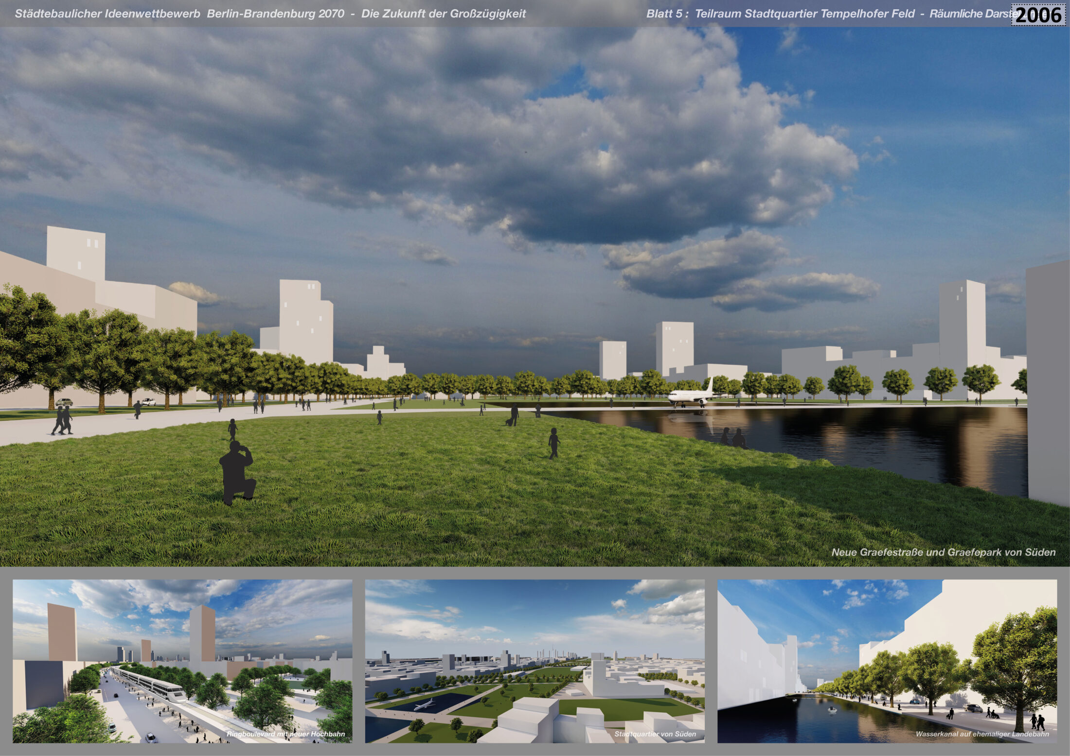
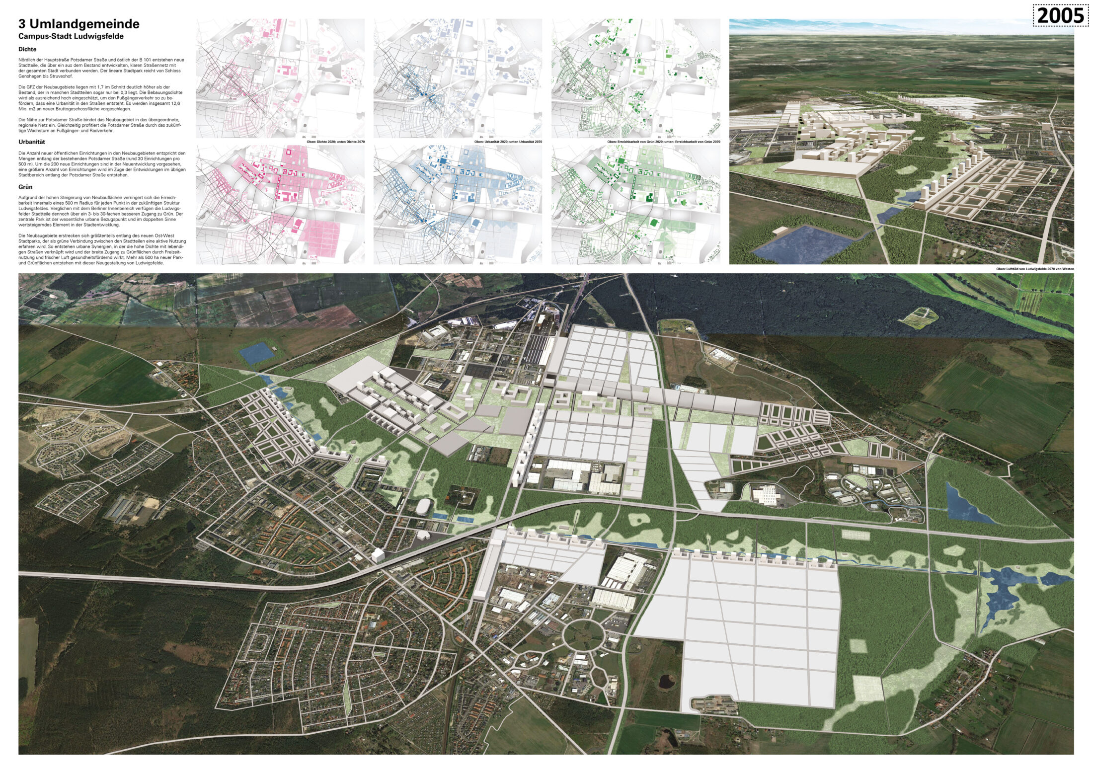
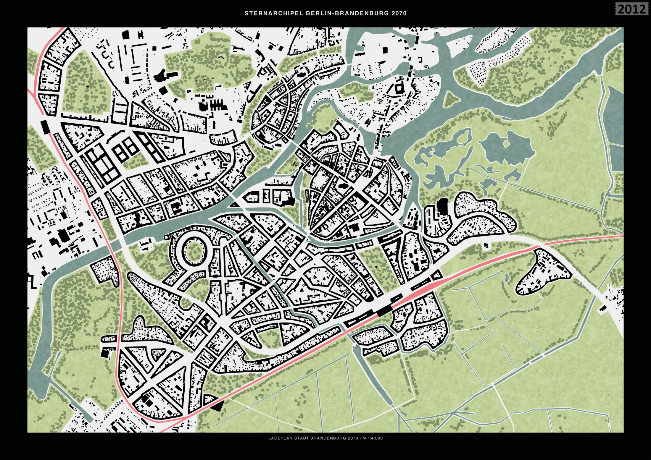
Sub-area 1 – Nauen


Sub-area 2 – Schmöckwitz


Sub-area 3 – Oranienburg


Entrant‘s description
Berlin-Brandenburg 2070 / Berlin-Brandenburg Ring City / Second Phase
The general discussion and planning process for the Berlin Brandenburg Ring City (Berlin-Brandenburg Ringstadt, or BBRS) can be further developed in three main areas: concept and planning; discussion and integration; and realisation and coordination.
Concept and Planning
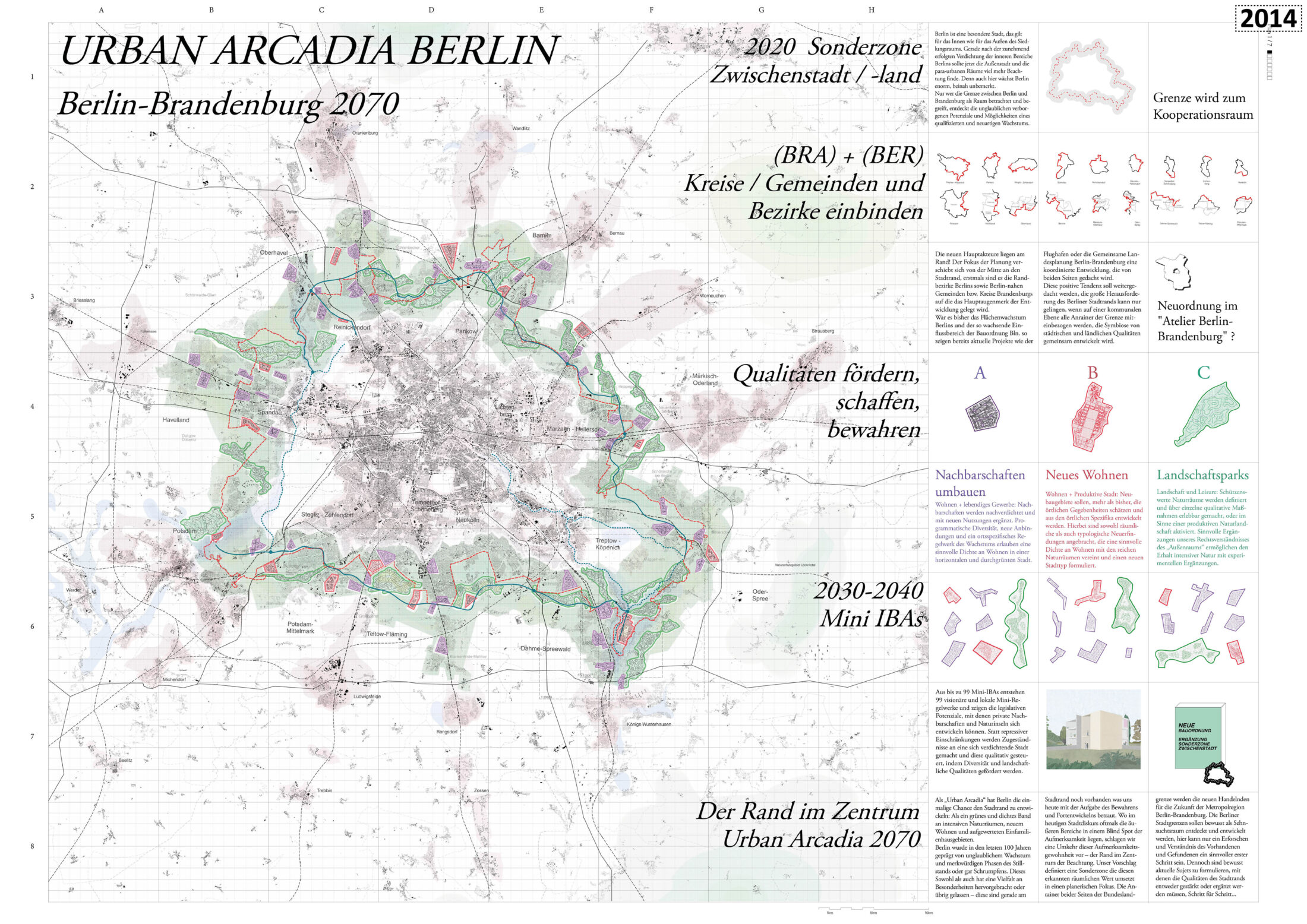
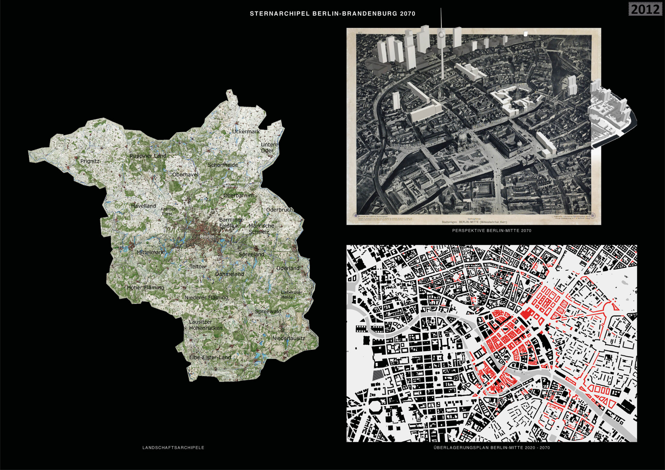
BBRS is based on a clearly structured and distinctive planning vision: a ring that has a diameter of 55 kilometres, a length of 178 kilometres and a width of 4 kilometres and that is designed to accommodate all future urban and landscape development in the Berlin-Brandenburg metropolitan region. The urban centres of economic, social, and cultural activity of this polycentric model are located at the intersections of the ring axis with the radial railway lines and the streets of Berlin’s historic star-shaped settlement structure. The Ring City model described here represents an alternative to urban sprawl and the simultaneous migration to rural areas. The concentration of urban growth along the ring or periphery enables the creation of a clear city edge, for both Berlin proper and the growing Ring City. The model shields the inner landscape between central Berlin and the Ring City from further urban sprawl and ensures the preservation of the surrounding Brandenburg landscape.
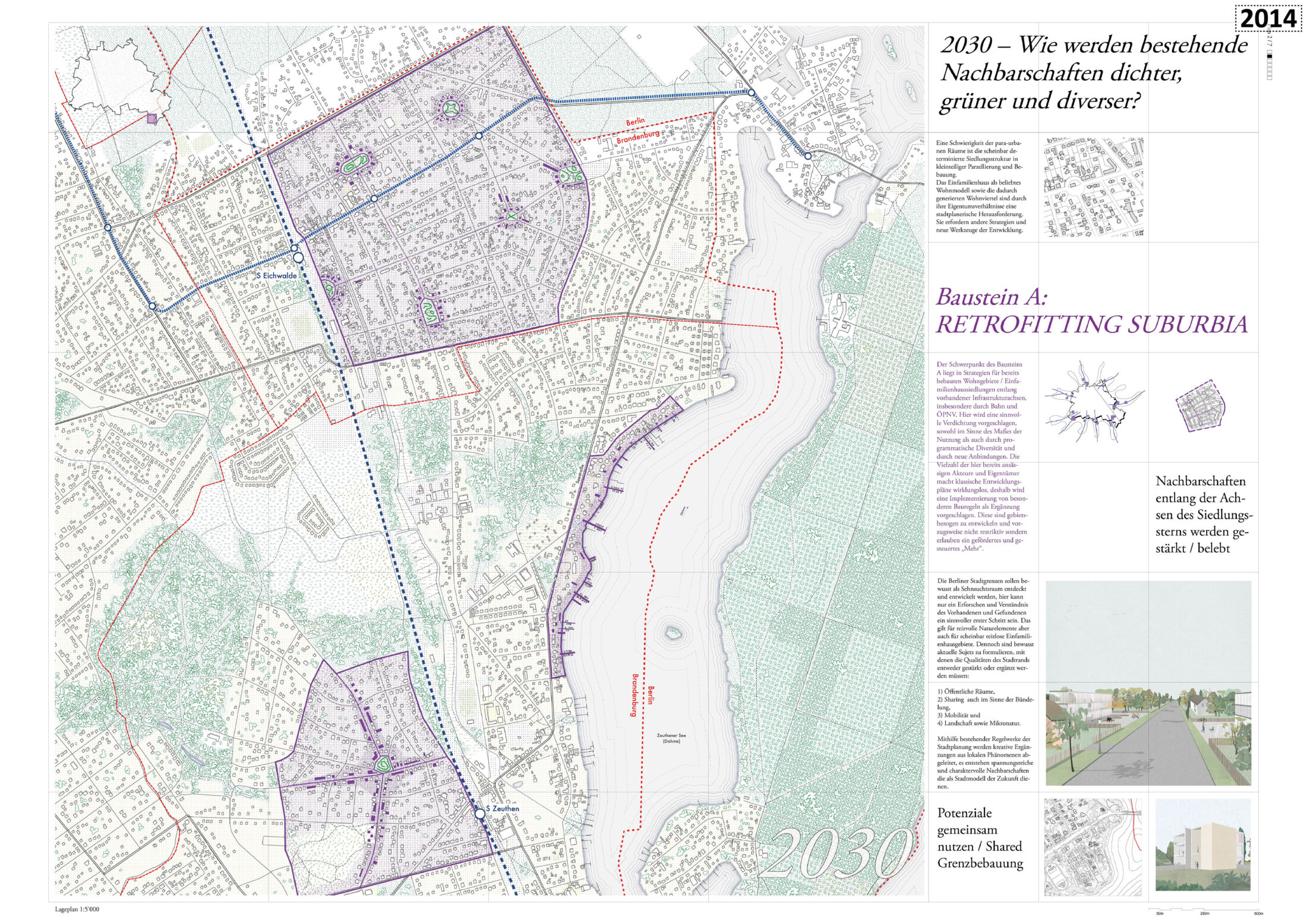
A further advantage of the ring model is the system’s high level of flexibility, which allows the development and implementation of long-term scenarios. The first step to this end should be to incorporate this concept in a BBRS master plan, which ought to include precise and binding planning requirements. These include designating the individual city fragments and landscape units which define the backbone and the structure of the Ring City: the Parkway, Gaps, Large Structures, Nodes, Islands, and Transit Landscapes. The further development and local planning of the Parkway, its residential and commercial areas, as well as of the open spaces, can subsequently be carried out by the public planning authorities and specialist planners based on the comprehensive master plan.
For the planning process, close cooperation between the urban and regional authorities with respect to the entire metropolitan region is necessary and should be accompanied and overseen by the appropriate individuals or entities at the various levels and in the specific areas. These include Brandenburg’s Ministry of Infrastructure and Regional Planning (MIL), Ministry of Agriculture, Environment, and Climate Protection (MLUK), and Ministry of Economy, Labour, and Energy (MWAE); Berlin’s Senate Department for Urban Development and Housing (SenSW) and Senate Department for Environment, Transport, and Climate Protection (SenUVK); and representatives of the Berlin-Brandenburg Joint Regional Planning Department. The BBRS master plan should also be integrated into the joint planning instrument of the Berlin-Brandenburg Development Plan (Landesentwicklungsplan Hauptstadtregion, LEP HR). Multi-disciplinary teams of experts made up of, among others, urban planners, architects, landscape architects, traffic planners, and environmental planners, should design land use and development plans at the municipal level with the involvement of the local population.
Discussion and Integration
The planning processes mentioned above must be united in a body that ensures fruitful communication among all involved parties and the development of a mutually acceptable implementation concept decided on by the democratic processes. The format of the International Building Exhibitions (IBA) for the development of new planning methods for urban and regional development has proven itself worthy time and again. Since the IBA Emscher Park (1989–1999) and IBA Fürst-Pückler-Land (2000–2010), planning-design issues and instruments for the structural change of entire regions have been developed and ecological, social, and economic issues addressed. In Berlin-Brandenburg the IBAs of 1957 and 1987 were of great importance. The experience with the International Garden Exhibition (IGA) 2017 Berlin-Marzahn and the Federal Garden Show (BUGA) 2001 in Potsdam are similar examples in the field of landscape design. The conception, integration, and communication processes successfully executed at many IBAs in recent decades can also be applied here. This would involve continuing and developing such experience and integrating new digital possibilities for an IBA Berlin-Brandenburg.
In addition to an IBA project advisory board at the administrative level, the involvement of regional, national, and international experts is recommended. This can be done through an IBA advisory board, although other theme specific approaches are also conceivable, such as planning workshops or architecture and landscape architecture competitions. Valuable partners could include the universities in the metropolitan region, the architectural associations of Berlin and Brandenburg, the German Academy for Urban Development and Regional Planning Berlin-Brandenburg, and the Future Berlin Foundation. Concrete suggestions for innovative forms of housing or the designing of areas in which to work, do business and dwell could be developed in an IBA Berlin-Brandenburg. An International Garden Show (IGA) could exemplify the possibilities for the development of open space, including future goals concerning recreation sites, sustainable agricultural production, and the preservation of valuable landscape elements. A specific aim of the BBRS, for example, could be to start a collective brainstorming process for reviving older identity-endowing symbols in the Ring City among political decision-makers, municipal and urban planning agencies, specialist planners, and the local population. Another could be to develop new concepts for areas that were formerly used for military or industrial purposes.
Realisation and Coordination
In the implementation of this project, it is vital that all important planning projects meet the requirements of the master plan. Examples include those dedicated to land use, transport routes, dwellings, utilities, and industrial areas. To this end, a superordinate planning coordination body with particular powers should be established. Similar coordination efforts would also be conceivable; for instance, the supplemental oversight of Berlin’s urban renewal over the past 30 years by the Berlin Senate and its authorities. Funds from federal and state governments, as well as support from the European Regional Development Fund (ERDF), could be obtained to finance and market BBRS. A team of economists and marketing specialists in the planning coordination office would be desirable for these projects. It would also be possible to enlist the services of a public operating company, similar to the state-owned Grün-Berlin group, which is responsible for the planning, implementation, and operation of several public green spaces in Berlin, and most for recently the IGA 2017 Berlin-Marzahn.
In the initial planning stage, existing centres located at the intersections of the star-shaped settlement arteries and the Ring City should be strengthened and new comparable locations created. It is important to define hierarchies and functional focal points together; to find a balance between cities of higher and lower importance; and to achieve an appropriate distribution of the catalysts for economic and cultural activity over the entire Ring City. In the following stages, the gradual expansion of residential, work, and recreational districts would take place. As would the gradual networking of the landscapes along transit and transport routes to superordinate green corridors. This would culminate in the creation of an extensive system of parks in the metropolis. A joint, cross-state, and interdisciplinary discourse involving all parties engaged in the concept and planning, as well as the use of superordinate planning bodies for its implementation, is indispensable for the successful realisation of Berlin Brandenburg Ring City BBRS.