A Series of Major Plans
Major plans have paved the way of Greater Berlin. It all began with the Greater Berlin Competition of 1908 – 1910. This was followed by efforts to create a general settlement plan for Berlin and a development plan for Brandenburg-Mitte during the Weimar Republic. Work on the general development plan continued under the direction of Albert Speer. Plans developed by the planning collective working with Hans Scharoun came immediately after the war and then came the grand plans for the divided city. Large-scale, trans-regional plans were developed after the fall of the Berlin Wall. The current plan follows the traditional star-shaped settlement model. All of these major plans served very different purposes – to generate interest, to call on authorities to commit to projects and goals, to provide guidance to private investors, but also to demonstrate socio-political objectives. Today, major plans have to meet all of these requirements.
The former Greater Berlin was not shaped or moulded; rather, it grew into the space available, sometimes incoherently. […] The suburbs […] felt that they were competing with the city, rather than being its satellites. They were soon so closely connected to Berlin and each other that the boundaries of the individual communities were no longer visible from the outside. The imperial capital had already become the economic, transport, cultural and social centre of the greater Berlin area by the 1880s.
When the new Berlin came into being in 1920, it faced extremely difficult urban development conditions. The first urban development task of the new single municipality was to leave behind fragmentation in favour of unity, and replace the lack of planning with planning. Efforts immediately focused on creating uniform building regulations and a uniform general development plan (general settlement plan).
Gustav Böß,
mayor of Greater Berlin from 1921 to 1929
Berlin Today, Berlin 1929
The Greater Berlin Competition of 1908 – 1910
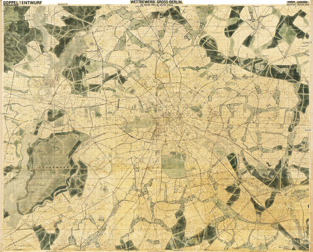
Hermann Jansen’s comprehensive plan was awarded first place in 1910. The international Greater Berlin Competition was judged in 1910 and focused for the first time on the planning of a new phenomenon: the constantly growing megacity. The integrated plan contained statements on housing, transport, green spaces and centres. The competition was organised by the Vereinigung Berliner Architekten and the Architekten-Verein zu Berlin (now Architekten- und Ingenieurverein zu Berlin-Brandenburg). It expected to receive proposals ranging from large-scale plans to detailed urban development projects. The competition involved many social stakeholders from politics, business, the arts and professional bodies. It also aimed to draw attention to the fact that this kind of planning makes sense and that the city needed a new political system: Greater Berlin.
The Creation of Greater Berlin in 1920

The general plan according to the Greater Berlin Act passed on 27 April 1920 shows the 20 boroughs and the permanent forest areas. The Act came into effect on 1 October 1920. The Province of Brandenburg was significantly reduced in size and the new municipality was divided into 20 boroughs. This was preceded by years, or even decades, of debate for and against the creation of Greater Berlin. It was also not clear where the borders of Greater Berlin should be drawn. After the Greater Berlin Competition, the Greater Berlin Joint Authority was established in 1912, but its powers were limited and as a result it was not very successful. The Joint Authority covered an area much larger than what would later become Greater Berlin, and the authority was dissolved in 1920. In the years after the creation of Greater Berlin, some districts tried, without success, to leave the Greater Berlin municipality.
Sub-plans of the Weimar Republic
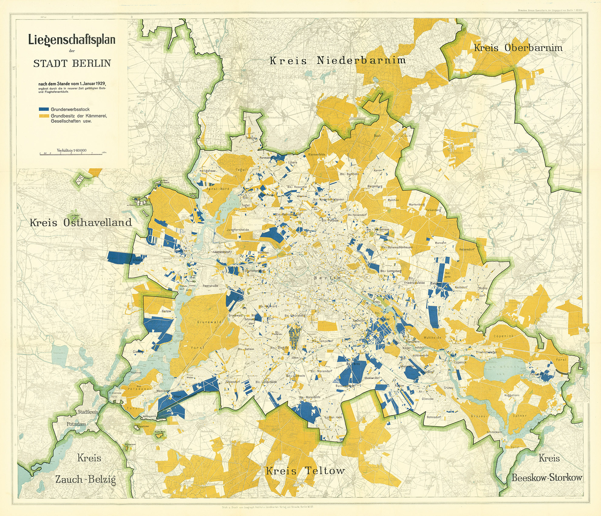
The Berlin property plan as of 1 January 1929. A new era of planning began after Greater Berlin was created in 1920. While private actors had a major influence on urban development before the First World War, the new municipality was now the dominant influence on housing construction, the provision of green spaces, energy supply and the reorganisation of the transport system. This was also made clear in the impressive land assembly policy – a consequence and condition of municipal urban planning. Comprehensive new plans were made. The Zoning Plan came into force in 1925 and the General Land Use Plan was published in 1929. A car-oriented street plan was also presented in 1929. However, despite all of the efforts made, it was not possible to develop a comprehensive general settlement plan.
The State Planning Association of Brandenburg-Mitte in 1935

A map of the Berlin-Brandenburg-Mitte economic plan designed by Gustav Langen in 1935. The creation of Greater Berlin reduced the size of the province of Brandenburg. The province now had fewer residents than Greater Berlin, and Greater Berlin was not part of the Provincial Association. Greater Berlin unsuccessfully attempted to incorporate more of its surrounding area in 1928. In response, the State Planning Association of Brandenburg-Mitte was created in 1929 and existed until 1937. The internationally renowned spatial planner Gustav Langen drew up a differentiated comprehensive plan (general settlement plan) for the association, and his plan has wrongly been ignored to this day. Langen envisaged compensation or supply areas for Berlin’s food supply in the city’s surrounding area. His plan also included a network of motorways and railway lines around Berlin that was later pursued.
The General Development Plan of Berlin’s General Building inspector (1937 – 1942)
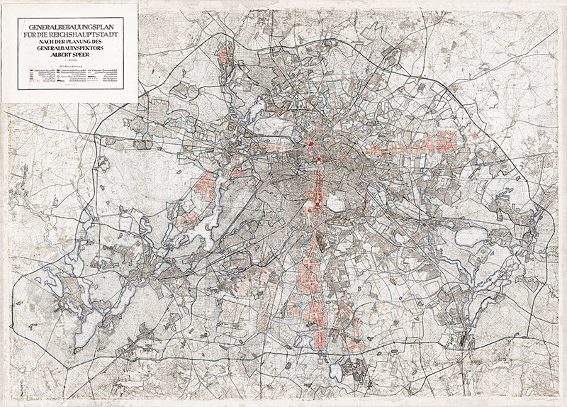
The General Development Plan (comprehensive plan) designed by Albert Speer in 1942. The position of General Building Inspector for the Reich Capital (GBI) was created on 30 January 1937 and tasked with drawing up a comprehensive construction plan for the Reich capital in Berlin. This state authority headed by Albert Speer was now responsible for planning the greater Berlin area. Municipal planning authorities no longer had a role to play and the municipal borders lost their meaning. This marked the beginning of a new urban development system. The formal framework for the expanded capital was to be a system of main roads made up of axes and ring roads. The fact that it would only be possible to partially implement this plan through the persecution of the Jews, the theft of resources and the use of forced labour was long suppressed. The new GBI was based in the palace at Pariser Platz 4 from 1938 onwards. The previous tenant, the Academy of Arts, moved to the Crown Prince’s Palace (Kronprinzenpalais).
The Division of Berlin into Zones of Occupation in 1945
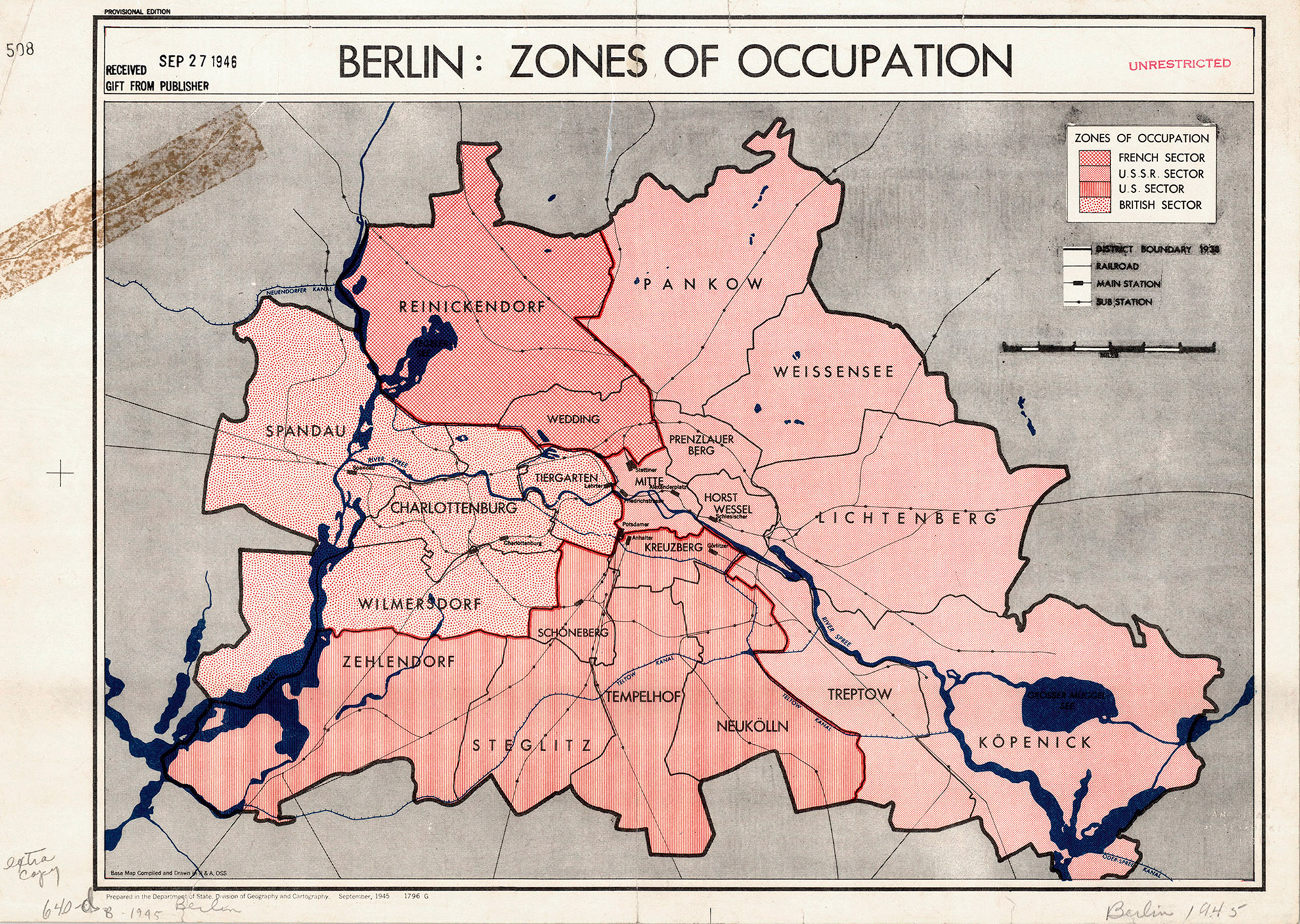
Berlin’s zones of occupation in 1945. Following Germany’s unconditional surrender in May 1945, the Allies controlled Berlin. Initially only the Soviet Union occupied Berlin, but the US, British and French occupying powers soon followed in July. It was decided in 1944 that Greater Berlin would be divided into sectors (initially without a French sector) based on the city and district boundaries determined by the Greater Berlin Act. The Magistrat of Greater Berlin, which was the official term used by the Allies, was still not a self-governing body, but rather an institution under the command of the Allies. The Allies also decided on issues concerning apartment and infrastructure repairs as well as urban development more generally. The Allied Kommandatura was set up as a joint governing body for the city, although it experienced increasing levels of conflict. It was headquartered in Kaiserswerther Strasse 16–18 in Zehlendorf.
The Collective Plan of 1945 /1946
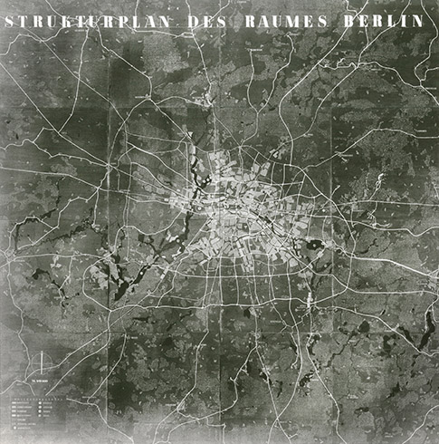
A structural plan of the Berlin area in 1945 / 1946. The collective plan was the first official plan to be drawn up after Germany’s unconditional surrender. After it was approved by the occupying powers, it was presented to the public in the ruins of Berlin Palace from 22 August to 15 October 1946. The plan was developed under the direction of Hans Scharoun, head of the Department for Building and Housing. It ignored tradition and instead embodied the vision of a new, car-oriented city and functionally separated urban landscape, which would extend in a strip-like, east–west-oriented band along the Spree glacial valley. Approaches in line with the traditional radial concept are visible on the outskirts. Scharoun was voted out in the first free elections on 20 October 1946, but the plan still had a major impact. In a time of extreme uncertainty, just thinking about a possible future was an act of hope.
East Berlin:
The 1953 Land Use Plan
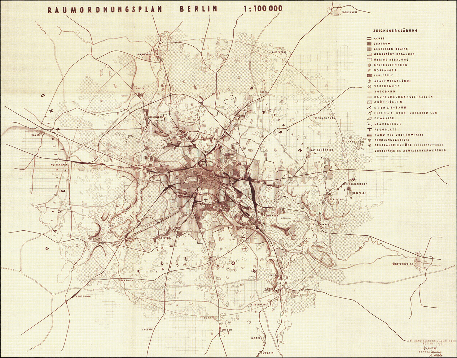
The East Berlin Land Use Plan of 1953. The 1953 Land Use Plan was based on the German Democratic Republic’s 16 principles of urban design and still showed Berlin and its surrounding area without the partition between east and west. The railway lines, including the outer railway ring, were emphasised, yet the outer Berliner Ring orbital motorway is barely noticeable. However, motorway planning played a key role. The plan emphasised the hierarchy of building density and, in particular, the diversity of the centres. Schönefeld Airport is shown, but is visibly smaller than Tempelhof Airport. The map extends in the north to Oranienburg and Eberswalde, in the east to Fürstenwalde, in the south to Zossen and in the west to Nauen. The circle marks a radius of 30 kilometres around the city centre. Compared to the collective plan, the 1953 plan respected the traditional city and avoided radical new visions of the city.
West Berlin:
The 1965 Land Use Plan

West Berlin’s 1965 Land Use Plan (adopted in 1970). West Berlin’s Land Use Plan was completed a few years after the Berlin Wall was built in 1965. In the long term, it has affected the city more than any other major plan since 1945. It had a clear concept: to modernise the western section of the city in a public initiative. The plan included the construction of large-scale housing developments, the redevelopment of parts of the inner city, the construction of a city motorway network and the expansion of the U-Bahn underground network. Overall, the plan was relatively effective thanks to the extensive federal funds that were made available to implement it. This, however, provides the background for the broad protest movement, active since the late 1960s, that had questioned some of the plan’s key projects.
East-Berlin:
The 1969 General Development Plan
The 1969 General Development Plan: plan of the structure and composition. Shortly after the West Berlin Land Use Plan was released, the Magistrat of Greater Berlin presented the General Development Plan together with the General Transport Plan in East Berlin. This plan also focused on the comprehensive restoration of the city with the aim of ‘creating a typical cityscape of the city of the first Workers’ and Farmers’ state’. The plan envisaged a ‘compact’ city with a clear centre and close integration of work, living and recreational spaces, developed using a local public transport system that included trams and a radial ring road system. Numerous multi-storey residential buildings and blocks were planned in the centre, while any urban sprawl into the outskirts was ruled out. This concept differed significantly from plans in other large western cities.
West Berlin:
The 1984 Land Use Plan
The 1984 Land Use Plan. West Berlin’s 1984 Land Use Plan embodied the fundamental change in perspective in urban development that had taken place within the context of massive social conflict during the 1970s and early 1980s. The expansion of the urban motorway with the tangent system was abandoned, and wholesale redevelopment projects were replaced by careful urban renewal projects and the construction of large housing developments on the outskirts of the city. The plan rediscovered the values of the old city. The International Building Exhibition (IBA 1984) was used to communicate the change. After the signing of the Basic Treaty of 1972, which gave the German Democratic Republic recognition as a sovereign state, the plan was no longer a tool of the Cold War. The plan did not come into effect until 1988 and therefore had very little time to produce results. However, its basic ideas survived the reunification process.
East Berlin:
The 1987 General Development Plan
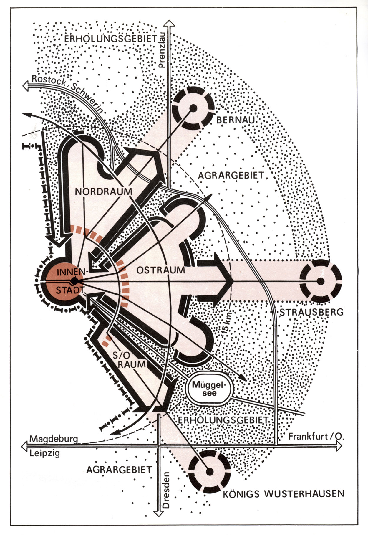
A diagram of the 1987 General Development Plan. The objectives had also fundamentally changed in East Berlin. The old city was given a completely new, positive profile in light of Berlin’s 750th anniversary in 1987. This was reflected in the construction of the Nikolaiviertel quarter and the Friedrichstadt projects. At the same time, construction continued on the large housing developments on the outskirts of the city; this had only begun in the 1970s. The large-scale orientation of the diagram is particularly striking. The General Development Plan shows a star-shaped settlement plan with green wedges, but only for half of the greater Berlin area. Potsdam did not appear on the map and was completely isolated. The East Berlin General Development Plan had even less time to take effect than West Berlin’s 1984 Land Use Plan, as it never entered into force.
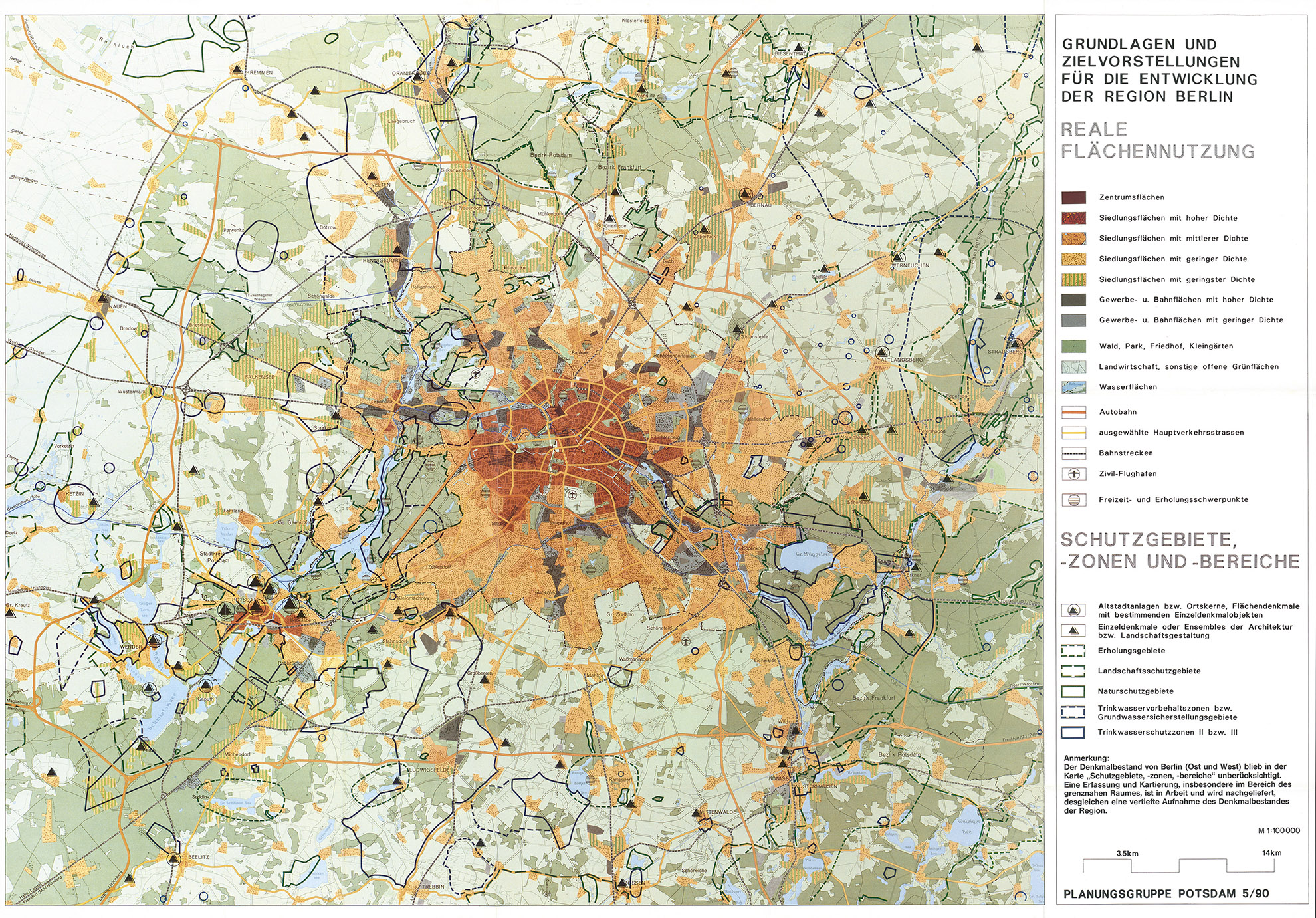
The 1990 Plan of the Provisional Regional Committee
The 1990 plan developed by the Potsdam Planning Group of the Provisional Regional Committee. The situation in Berlin changed dramatically just three years after the General Development Plan was presented. The Berlin Wall fell and spatial perspectives underwent a revolution. Before reunification, a group of East and West German experts from Berlin and its surrounding area met and formed the Potsdam Planning Group of the Provisional Regional Committee. The group recommended preventing urban sprawl, safeguarding open spaces, strengthening the city’s existing centres, preserving the region’s cultural urban development values, striving for equal living conditions and improving public transport, all in an environmentally and socially responsible manner. In terms of spatial development, it was decided to allow the city to develop along the radial settlement structures that had formed over the past 100 years.
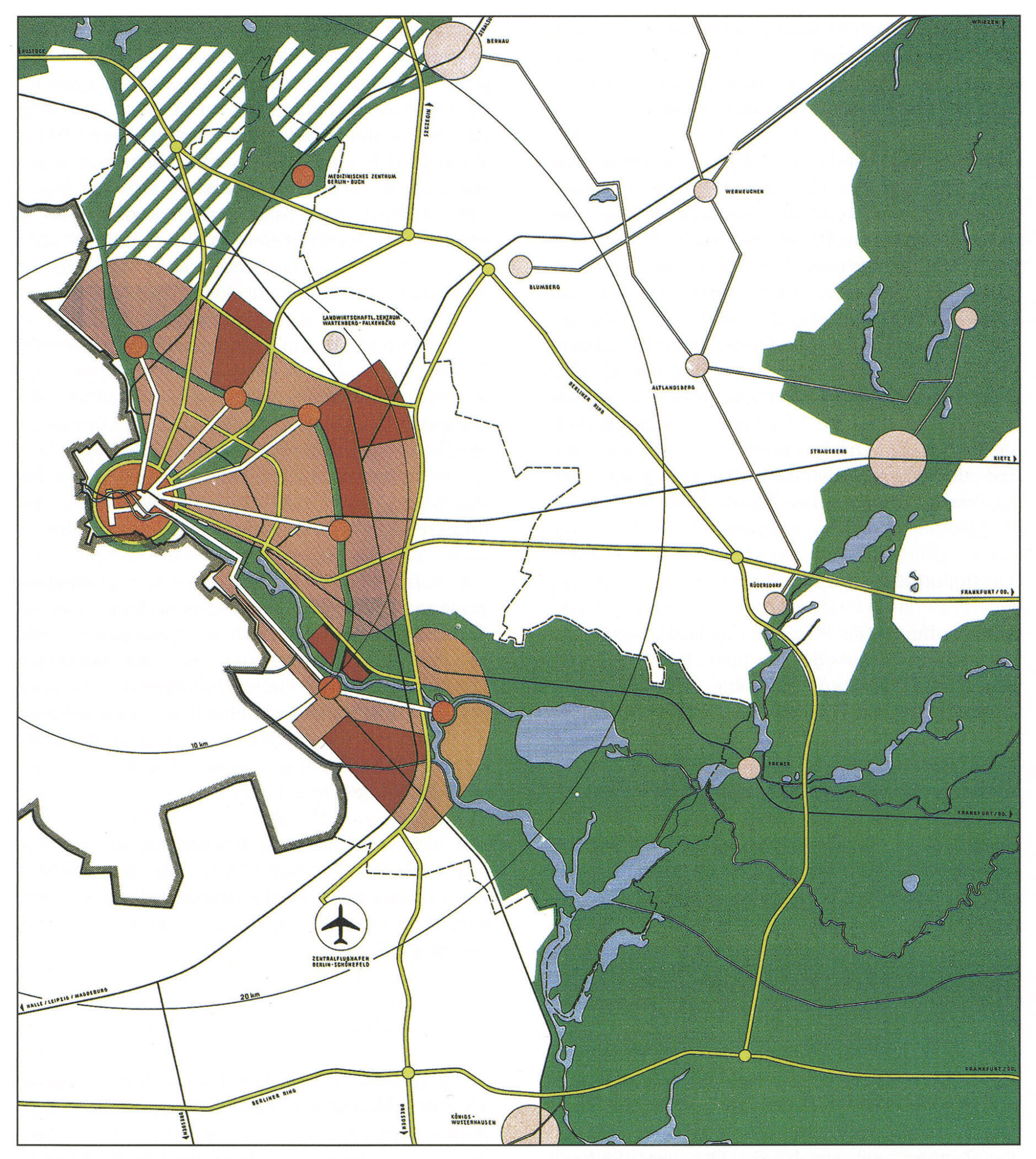
The 2019 State Development Plan
The 2019 State Development Plan Capital Region Berlin-Brandenburg (LEP HR). The new state development plan entered into force on 1 July 2019. It is the result of the specialist work carried out by the Joint Spatial Planning Department of Berlin and Brandenburg, which was created in 1996. The star-shaped settlement pattern is an overarching guiding principle, an urban regional model that has developed gradually since the 1880s. The goal is for the city to grow along the lines of the suburban railways and major arterial roads, and this will be reinforced by the expansion of the public transport system. The plan builds on the urban region’s special features and strengths, which is a sustainable concept in principle.
