Jordi & Keller Architekten / Pellnitz Architektur und Städtebau Location: Berlin www.jordi-keller.de www.pellnitz.de Team: M. Eng. Yannick Langer, Dipl.-Ing. Nandor Kovac, Frederic Jordi Landscape planning: Christina Kautz Landschaftsarchitektur Other specialist planning: Ludwig Krause (traffic and urban planner)
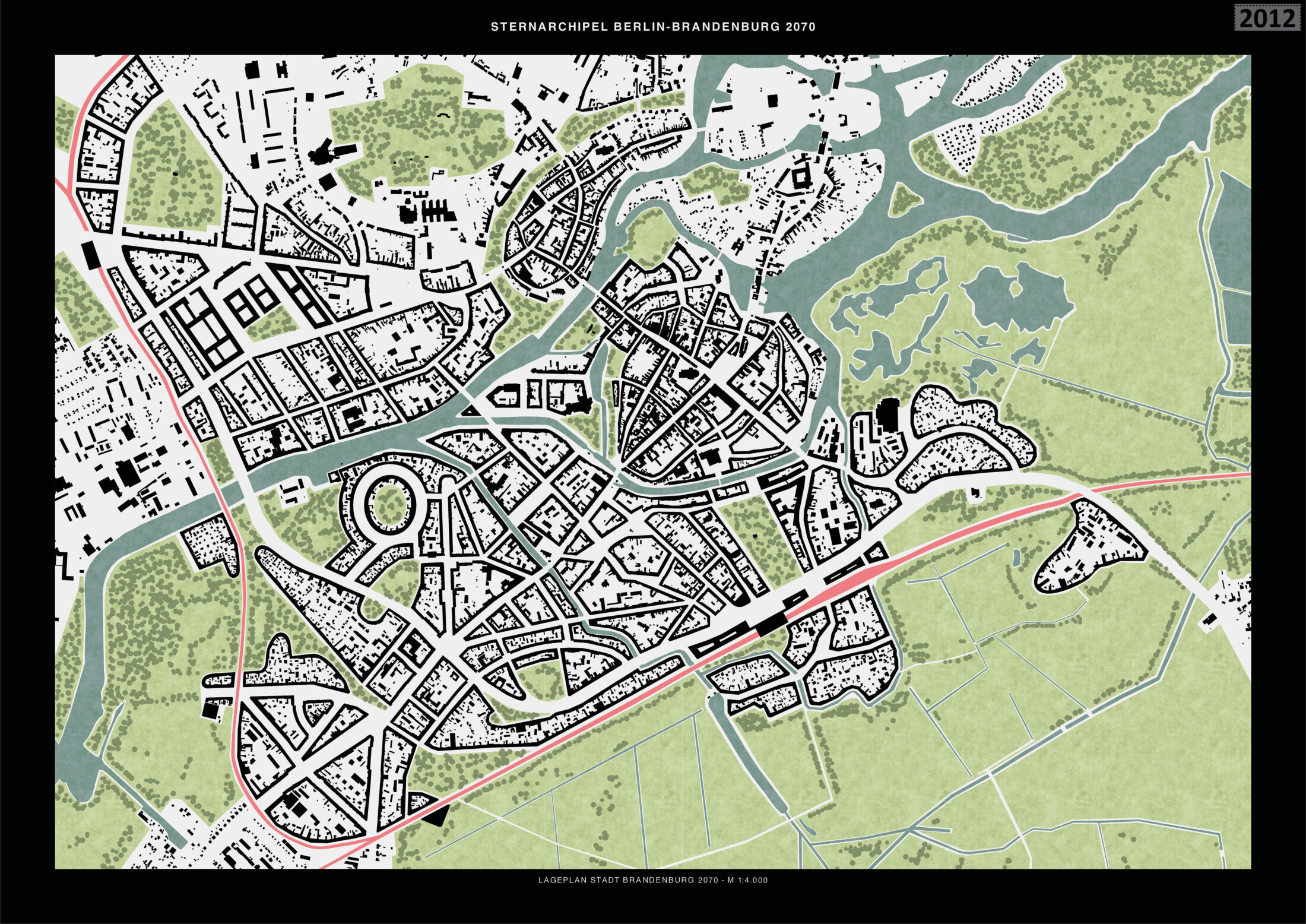
Sub-area 1: ‘Brandenburg an der Havel’
With the planned construction of the third and fourth railway rings in the metropolitan area, it is conceivable that Brandenburg an der Havel can be densified to accommodate twice its current population. The aim of the urban development plan is to promote closer interconnection between city and nature while considering historical identities. The existing buildings between Neustadt and the railway station are structurally upgraded by closing the blocks. The structures within the blocks are largely preserved. Potential development areas are located southwest of the station and in the west of the old town up to the railway line. In addition, south of the station, along the Jakobsgraben canal, the existing buildings, which have a more open composition, are densified with street-fronting buildings. When viewed from above, the expanded block structure harmonises the urban structure.
Sub-area 2: ‘Westkreuz’
Currently, when various transport systems going in different directions intersect, traffic jams and structural overloads occur, especially at peak times. The AVUS (Automobile Traffic and Practice Road) was the world’s first road created specifically for automobiles and was once an important car-racing circuit. It is redesigned as a boulevard in this concept. The car traffic is redirected underground, and the rail traffic is above ground. The track systems are converted into a green space that connects the nearby Lietzensee Park with Grunewald. The north curve houses a new football stadium, and the urban planning additions adhere to the Charlottenburg block structure. The dominant element is a gate-like situation formed by two highrise buildings with a height of up to 200 metres. A similar ensemble is also to be built at the three other train stations.
Sub-area 3: ‘Berlin-Mitte’
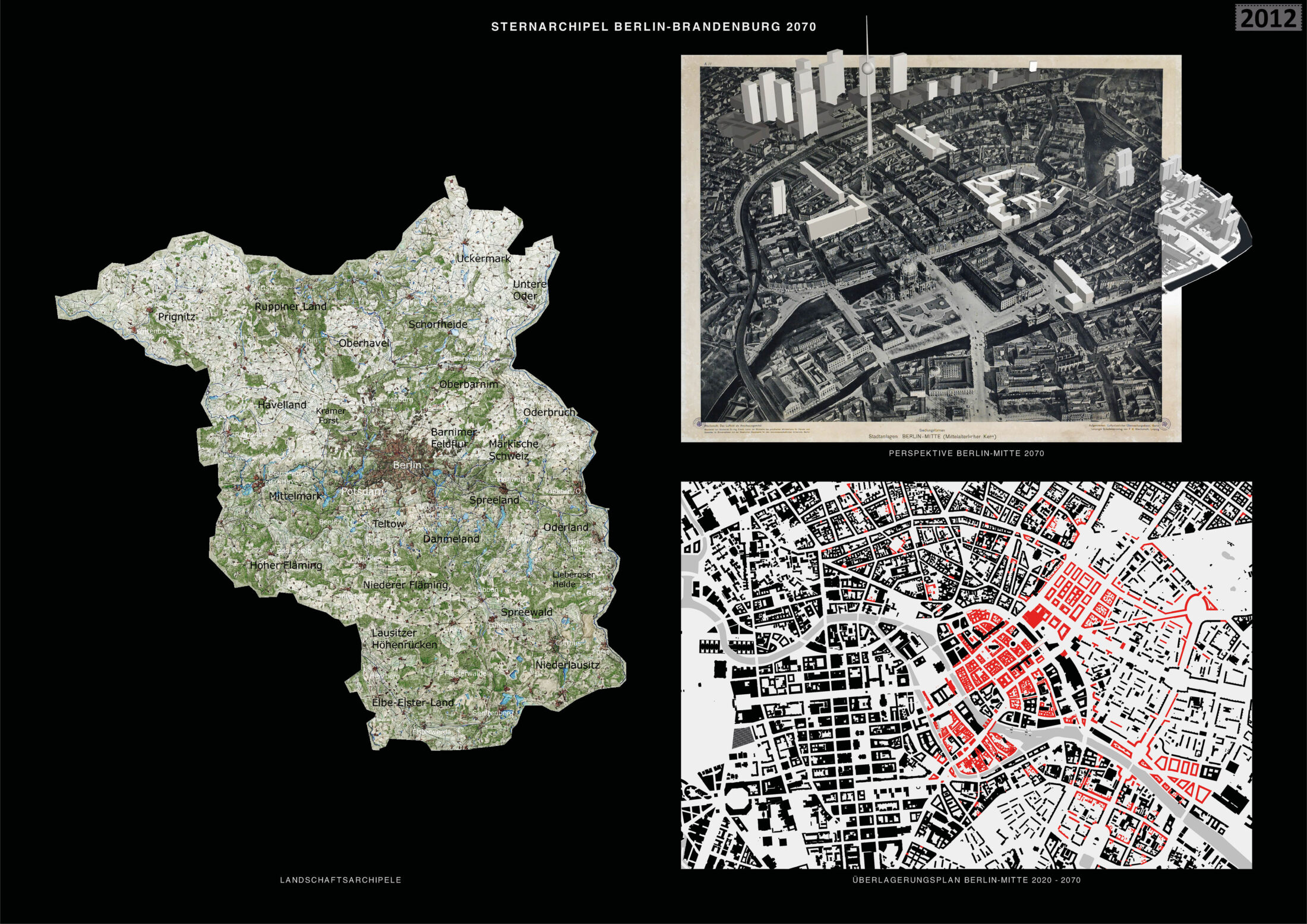
Only a few entries focused on Berlin-Mitte. The centre is roughly based on the historic centre of 1920. Parts of the neighbouring royal city are also enhanced based on the city plan from 1920. The Stralau Vorstadt (Stralau Suburb) is densified along the street with large residential buildings. The concept supports the idea of strengthening the historic centre with historicist architecture and additional cultural facilities. The existing housing will enter into a ‘coalition’ with the reconstructed city plan. Peter Joseph Lenné’s idea of integrating ‘jewelled water axes’ into the city is revisited. The concept proposes extending the waterway from the Engelbecken in Kreuzberg to Volkspark Friedrichshain via Strausberger Platz. The waterway is to be designed on both sides as a green space with avenues and recreational spaces.
Entrant‘s description
Star-shaped Archipelago Berlin-Brandenburg 2070 – Urban Development Concept Berlin-Brandenburg was formed out of various villages and towns. This development has led to an archipelago of centres, within and beyond Berlin, that are connected by radial axes and circular railway rings. The structure within Berlin’s inner railway ring is characterised by green islands in the dense, urban sea of houses; beyond the ring, it is characterised by settlement islands separated by green and natural spaces. Between the radials of the star-shaped structure of Berlin, the large landscape areas protrude far into the centre of the metropolitan region. The star-shaped archipelago, with its dialectic between nature and development, represents the greatest qualities and potentials of the Berlin-Brandenburg metropolitan region. These need to be strengthened and further developed. New building sites and residential areas should be created largely within this structure based on the conversion, consolidation, and modification of existing settlement areas. The current star-shaped structure of the Berlin-Brandenburg metropolitan region is to be expanded and differentiated with the star-shaped archipelago model proposed here. The concept of the star-shaped settlement – especially in conjunction with its visual representation in the Berlin-Brandenburg regional development plan – evokes a sense of unlimited densification within the star-shaped settlement structure. As such, it does not consider the infiltration of urbanised areas into the surrounding nature. The concept of the star-shaped archipelago, which is based on the concept of Berlin as a ‘green archipelago’ and on ideas from the Greater Berlin Competition of 1910, is to pursue this dialectical interpenetration of city and nature as a new model.
Decentralisation Goal The federal government’s decentralisation goal sets out to create equal living conditions throughout the region, with a special focus on structurally weaker rural areas. Accordingly, this urban development concept assumes that Brandenburg’s existing towns and cities will be strengthened over the long term, in part to relieve the pressure on Berlin. The measures proposed here can accommodate up to twice the number of inhabitants in the metropolitan region without compromising the quality of outdoor spaces and with only a minimal amount of additional soil sealing.
Railway Rings Berlin currently has an inner railway ring and an outer railway ring. Two additional railway rings will be created. These will link the existing centres along the radial railway lines, strengthening them and helping to reduce transit traffic through Berlin. The third ring will largely run on existing railway tracks or directly along the Berlin circular motorway or ring road and will connect towns such as Oranienburg, Bernau, Straußberg, Königs Wusterhausen, Beelitz, and Nauen. The fourth ring will connect the so-called ‘second-tier ’cities, including Brandenburg an der Havel, Frankfurt an der Oder, and Cottbus. Both rings could link new sites that emerge for industries and businesses (such as Tesla) with the next locations on the respective ring. As a result, these sites will remain close to the new settlements and to Berlin.
Sub-area Brandenburg an der Havel The strengthening of second-tier cities such as Brandenburg an der Havel, Frankfurt an der Oder, and Cottbus is a focus of the strategic development concept. The great qualities of these cities – their unity with the landscape, their historic city centres, and their good connections to Berlin – make them ideal as regional centres. When expanding these cities, it is important to preserve their historical character and their close connection to nature. The city of Brandenburg an der Havel is a good example of a second-tier city. The existing structures and the natural and organic elements of the city are integrated and further developed. The existing buildings with their block structures are further densified and extended to the city’s edge, marking a clear transition to the surrounding landscape. The contrast between the organic forms of the city, which can be found in the historic centre, and the typical elements of industrial development such as tall silos, is explored in the form of new landmarks. At the same time, the natural spaces also enter into the city, so that the city and nature reconnect in a variety of ways.
Sub-area Westkreuz The basic ideas of the master plan are exemplified by the development plan for the Westkreuz area: densification within the settlement boundaries, the development and conversion of traffic areas and unused areas, and the strengthening of the intersections of the railway rings and railway radials. The Westkreuz suburban railway station will be expanded to become a regional railway station which, like the Gesundbrunnen station, will allow riders to transfer from regional trains from the surrounding areas to the suburban ring railway. The motorway will now run underground and be partially dismantled. This will eliminate its destructive ‘barrier effect’. A dense, socially and functionally mixed urban district is planned on the large site and will be networked with the surrounding quarters. At Westkreuz, and at the three other railway intersections (Südkreuz, Ostkreuz, and Nordkreuz), two high-rise buildings with a height of between 100 and 200 metres will be built as a gateway to central Berlin. These pairs of high-rise buildings frame the high-rise groups in the central locations in the city centre. Most of the old railway tracks will be converted into a park, which will connect Grunewald to the east-west axis via the Lietzensee Park. The east-west axis will be developed into a green boulevard with rows of trees and a bicycle expressway in the middle.
Sub-area Berlin-Mitte A discussion of the Berlin-Brandenburg metropolitan region cannot overlook its centre, the historic heart of Berlin. Although the strategic development in the present concept primarily focuses on strengthening towns on the rings, central Berlin plays a vital role for the entire region. The historical development of Berlin from a small settlement into the political centre of Germany can only be observed here. The cultural institutions in the city centre also radiate across the entire metropolitan region. For the medieval core, it is proposed that the existing buildings from the GDR era are brought into a dialogue with a critical reconstruction of the historic city plan, so that Berlin’s long history is once again legible and the individual histories of the buildings can be remembered through their historical addresses. To the east of Berlin’s medieval centre, Lenné’s ‘green corridor’ project is revisited, and the connection between the Engelbecken and Volkspark Friedrichshain (via Straussberger Platz) is converted into a continuous green corridor and monumentalised by large urban squares.
Strategic Reflections on the Process As yet, there is no common, trans-national public discourse on the strategic development of the Berlin-Brandenburg metropolitan region. With its plans and images, the Berlin-Brandenburg 2070 competition offers an outstanding opportunity to initiate and advance this discussion. The winners of the competition should develop a common and comprehensive concept for the area’s long-term development through a multi-year process involving a dialogue with the public. This should be conducted in cooperation with the joint state planning authorities and in exchange with the citizens of the two states.