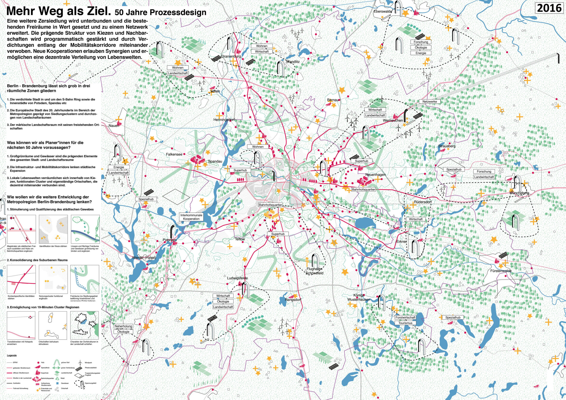
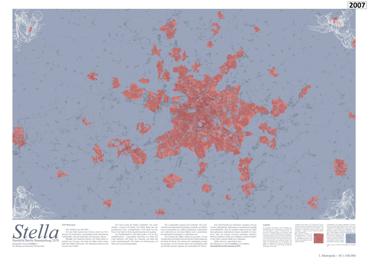
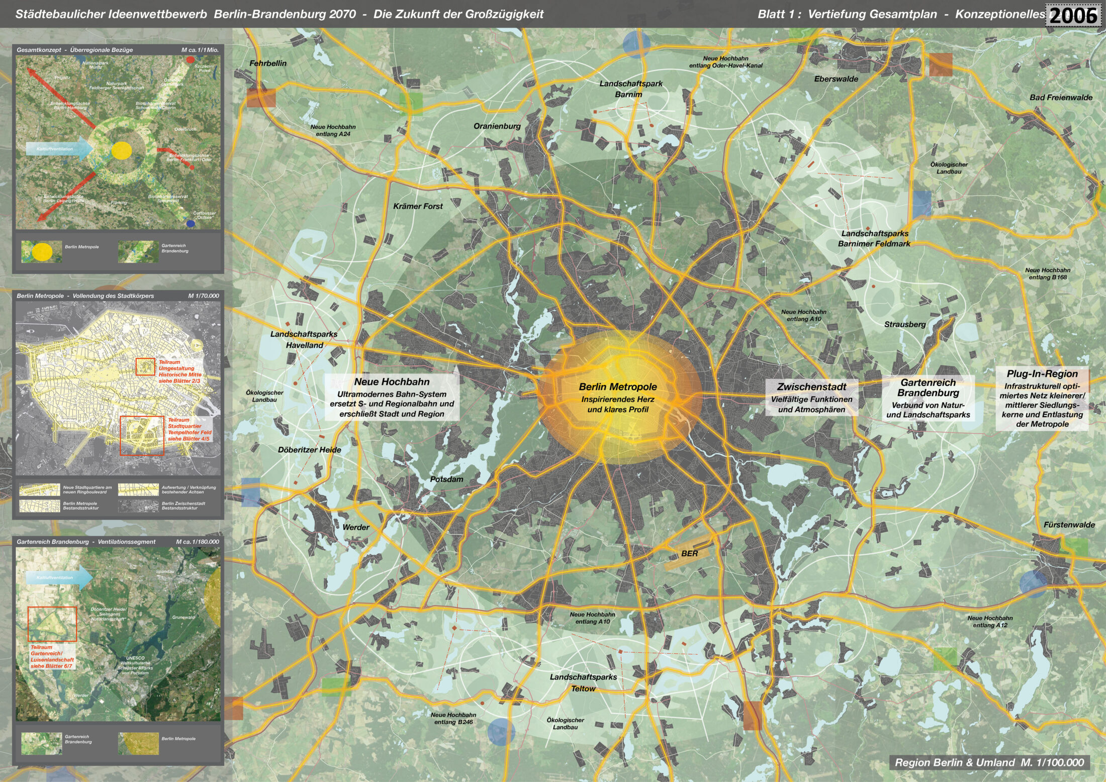
Metropolis Berlin: the profile of Berlin city centre as the inspiring heart of a vital metropolis is heightened. An urban-climatic, socially conscious densification intensifies the urban atmosphere.
Garden Domain Brandenburg: a relationship between park, paths, and visual connections is created in the area of the outer ring road. Forests and bodies of water are enhanced, regional parks are linked, biodiversity is promoted, and ecologically reformed agriculture and forestry are harmoniously embedded in the Brandenburg landscape. There are expansion options for the Garden Domain, including existing in biosphere reserves to the northeast as a trans-European project with Szczecin/Poland, and to the southeast towards Cottbuser Ostsee lake.
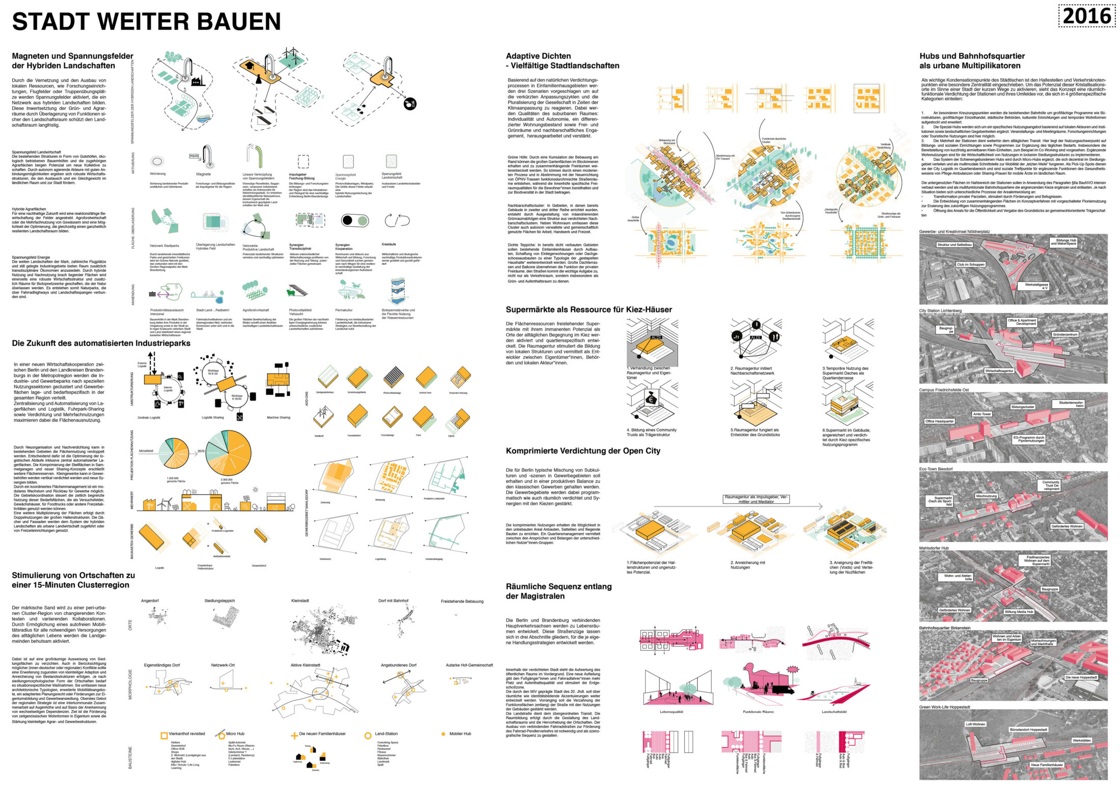
In-between City: between the metropolis and the Garden Domain, various functions and environments are possible; these are determined individually and locally, free of guidelines from above.
Elevated railway: a new elevated railway system replaces the S-Bahn and regional railway networks and provides the city and region with maximum comfort and efficiency. Other transport links are created over or along motorways and A-roads, which avoids further land consumption.
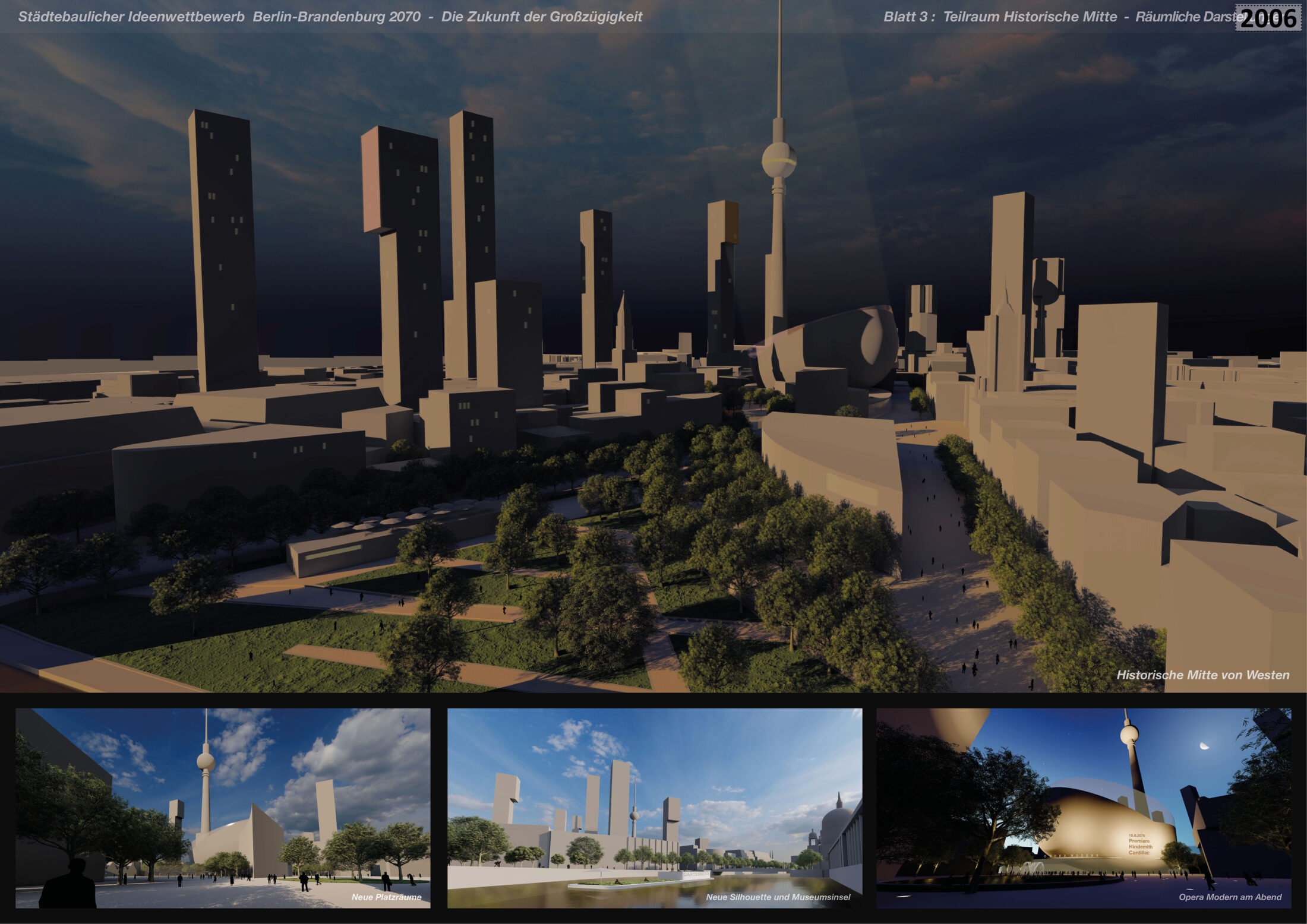
Berlin’s Historical Centre as a Sub-space: In Search of Lost Time
‘All these memories added to one another now formed a single mass, but one could still distinguish between them – between the oldest, and those that were more recent, born of a fragrance, and then those that were only memories belong to another person from whom I had learned them – if not fissures, if not true faults, at least that veining, that variegation of colouring, which in certain rocks, in certain marbles, reveal differences in origin, in age, in “formation.”’(Marcel Proust, ‘In Search of Lost Time’)
The ideological weight of Berlin’s historical centre is dispelled in favour of the primacy of its urban quality. The central and symmetrical staging of the ‘GDR capital’ is vanquished, as is the nostalgic idea of a ‘reconstruction of the old town’. Buildings worth preserving are complemented by new structures, streets, and public spaces. Buildings classified as expendable will be made available for development over time. Institutions that were once located in the historical Mitte, such as the synagogue in Rosenstrasse or the Central Market Halls around the train station at Alexanderplatz, are repurposed or reinterpreted. The TV Tower is integrated into a sculpturally coordinated high-rise ensemble. New establishments of high culture are changing the currently dull commercial atmosphere. The Garden Domain Ferries, which deliberately have no schedule, connect the centre with the Garden Domain and offer users a chance to slow down.
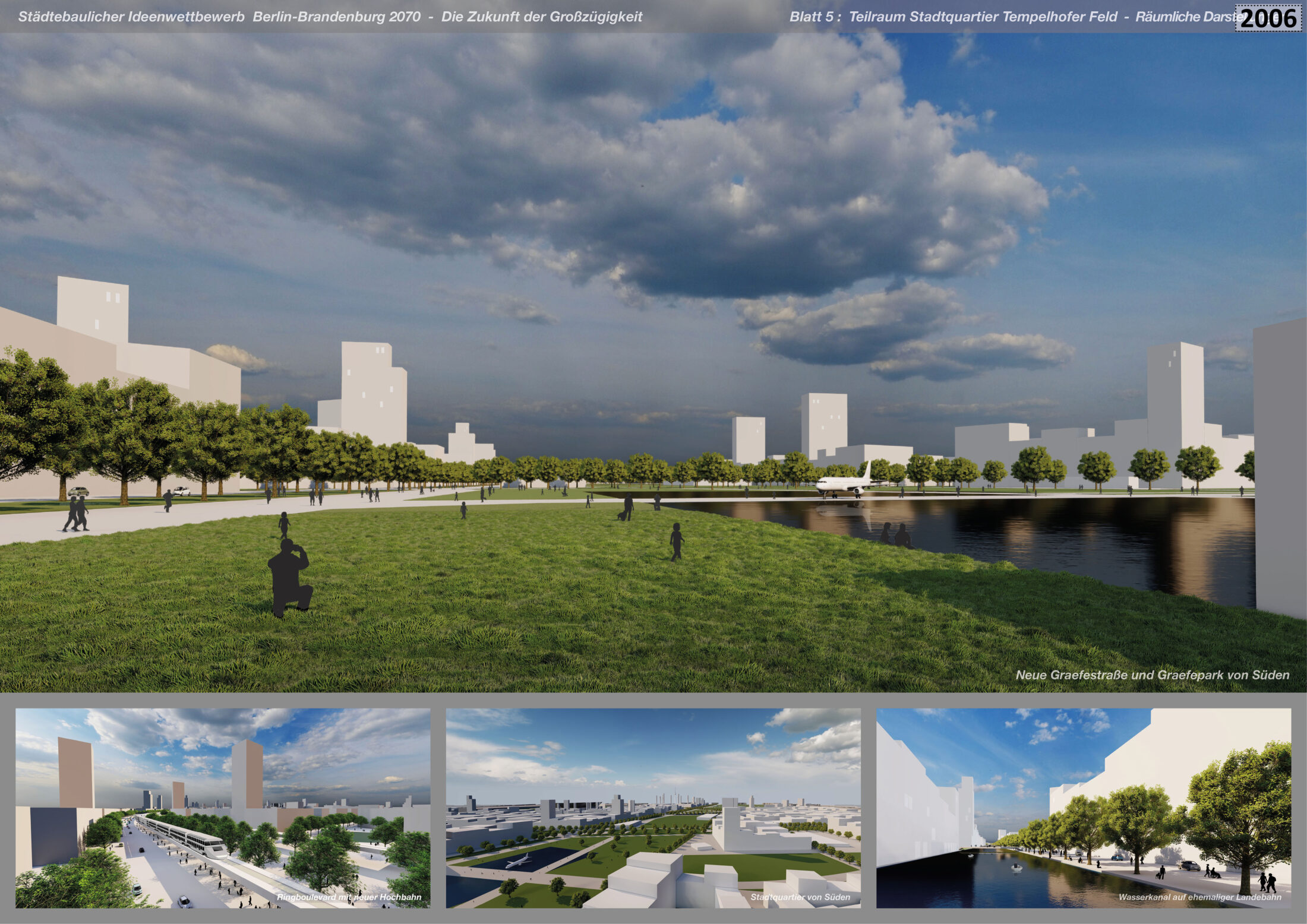
The New Urban District of Tempelhofer Feld as a Sub-space: Urbanism as a Resource
More than simply satisfying predicted space requirements, which naturally fluctuate over time, the goal of this proposed new district is to further develop Berlin’s exciting and charismatic character: animated urbanity promotes efficiency and sustainability, social exchange and cohesion, and experimentation, as well as providing inspiration. The prerequisites for its development are the seamless linking of high-quality public spaces; the seemless connection to comfortable public transport; street-level zones suitable for retail, gastronomy, and other services; the conscious cultivation of the city’s public sphere and its clear demarcation from the private realm.
As in our plans for Berlin’s historical centre, we propose closed block structures and classic street and square spaces for the Tempelhofer Feld district. Strictly controlled plot sizes create a lively cityscape and allow for a mixed ownership structure. The contrasting height gradation of the new buildings permits the densification of diverse functions, atmospheres, and spatial qualities, and produces a lively and pleasant cityscape. In the spatial dialogue with the historic airport building, a new, flexible football stadium for Berlin can be built (it can be converted into a large park-side stage, made possible via sliding grandstands). In the southern section, the A100 motorway and the S-Bahn line is replaced by the new Ring Boulevard, which encircles the city centre and integrates all modes of transport in a single, spacious urban area. The centrally located Garden Domain Market Hall offers local, sustainably produced products.
The Garden Domain as a Sub-space of Brandenburg / Luisen Landscape: The Discovery of Slowness
‘Now John looked more closely at the St James clock. The dial was painted on the stone on the edge of the thick tower. There was only one hand, and it had to be advanced three times a day. John had heard a remark that linked him to the stubborn clockwork. He did not understand it, but ever since he thought the clock had something to do with him.’ (Sten Nadolny, ‘The Discovery of Slowness’)
With Berlin’s urban heart beating ever faster, a complementary counter pole of emphatic ‘slowness’ is needed. The basic idea of the Garden Domain is exemplified by an area northwest of Potsdam: the area, which is almost completely surrounded by water, is still part of Potsdam’s World Heritage and has a prevailing west wind, which is important for the ventilation and cooling of the city. Thanks to the new elevated railway over the A10, the area has good transport links and thus constitutes a steppingstone into the Garden Domain.
A peculiarity of this area is its history associated with the Paretz Palace, a former country estate: built for Friedrich Wilhelm III and Queen Luise in 1798, it was exceptionally modest for the time. The royal couple’s legendary ‘modern’ spirit is reflected in the relaxed serenity of the Havel landscape and the landscape gardens by Lenné. The latter adorned not only the royal palaces, but also countless larger and smaller estates in Margraviate of Brandenburg, places which are often subject to decay today. The concept of the Garden Domain includes both saving this cultural heritage from disappearing and revitalising it. In homage to its history, we propose the name ‘Luisen Landscape’ (Luisenlandschaft) for the Garden Domain park near Paretz.
Like the Garden Domain as a whole, Luisen Landscape includes ecological and climate-related aspects; an aesthetic dimension that includes culture, history, leisure, and relaxation; and areas for a renaissance of the small-scale vegetable and fruit cultivation that has traditionally shaped this region. A Matisse-inspired landscape installation of lavender fields flows over the gentle topography. This imaginatively unites all three themes and forms an unmistakable landmark for the area.
A ‘Garden Domain Academy’ in the north teaches visitors about nature and the landscape. An Innovation Campus for research and development with future-oriented jobs for the region will be built directly to the east of the elevated railway station. Garden Domain Ferries connect the park and the Garden Domain with the city and invite visitors to rediscover slowness. Experiencing scenic beauty can prompt people to emotionally bond with places, stir an interest in nature and history, motivate engagement in efforts to promote an intact ecology, and provide a home environment worth living in.
Realisation Strategies: A Culture of Local and Personal Responsibility and National Lighthouse Projects
In Berlin today major projects are emerging – projects which ignore the scale of the city created during the Gründerzeit and render Berlin interchangeable with other world cities. Brandenburg’s agriculture is also becoming increasingly concentrated and industrialised. Razed landscapes and the devaluation of soil, water, and biodiversity have been the result. For inner cities and surrounding areas, we therefore advocate a shift back to an intelligent, small-scale approach and personal responsibility. In the new city districts, we have planned a maximum size for plots. Leasehold models can help to maintain the influence of society’s need for land use in the long term. In the surrounding area and region, we propose the return of self-rule at the village level and the division of oversized farms into manageable units.
Metropolis Berlin and Garden Domain Brandenburg make special demands that require a strong cultural awareness in society, politics, and administrations. Lighthouse projects help create impulses and shift prevailing tides. In this sense, Metropolis Berlin and Garden Domain Brandenburg could be developed as long-term national lighthouse projects: spatially limited special zones, in which a system of specific priorities prevails, and where exceptional characteristics quickly become clear. The brighter these projects shine, the more they influence the general perception of them. In an ideal scenario, they gradually create the necessary conditions for their own success.