KOPPERROTH / SMAQ / Alex Wall Location: Berlin / Berlin / Cambridge (USA) www.kopperroth.de / www.smaq.net / www.alexwall.com Team: Evelina Faliagka, Moritz Maria Karl, Dominik Renner Landscape architecture: Dipl.-Ing. Stefan Tischer, freelance landscape architect Other specialist planning: Office MMK – Urban Technologies
Sub-area 1:
At the edges of the settlement radials, areas are divided into small parcels to promote a mix of uses. This not only stimulate agriculture, but spatially defines the populated areas. The parcels structure a dense network of paths and create parklike landscapes. Existing settlements are supplemented, and new development areas for housing, recreational activities, and energy facilities are set in a spatially defined environment. This in-between landscape can be used as an experimental space for organic farming, decentralised energy supply, and alternative settlement areas, which simultaneously counteracts urban sprawl. Special places are marked and represented in the form of zeros, or circles. As a result, individual uses such as small settlements, agricultural businesses, and energy systems can be placed in the landscape.
Sub-area 2:
Inspired by the spatial arrangement of allotment gardens, ‘parcels’ measuring 150 x 150 metres are defined. Each of these clusters can be divided and expanded to accommodate different uses. The supply of energy and water is decentralised and is managed through collective self-government. 50 per cent of each parcel must be cultivated agriculturally to maintain the character of a park landscape. The parcels are enclosed by hollows and depressions, which ensure the retention and infiltration of surface water along the path system. The planting of trees and hedges creates natural corridors that improve the microclimate. The outlined grid depicts the network of public paths. The parcels are awarded in the form of heritable leaseholds based on concept-based applications. This land-use concept promotes social and ecological forms of living with the aim of establishing a ‘transition society’ for more open and flexible lifestyles.
Sub-area 3:
There are allotment gardens with low structural density along main access roads such as the A114 and the suburban railway line between Französisches Buchholz and Blankenfelde (including the Blankenfelde railway station and a new possible railway station on Bucherstrasse). These areas are suitable for new developments, particularly since technical infrastructure and public transport are already available. Here, the concept is centred on orderly densification along the radials. Existing landscape elements such as avenues, alluvial meadows, and the Panke River are renaturalised. The desired mixed-use environment, which includes housing, office spaces, manufacturing, and logistics centres, generates a variety of building typologies that allow high structural density. In the areas that transition to the historic green villages, the design places housing estates with single-family homes and integrates a small part of the allotment garden settlements into the landscape area.
Entrant‘s description
Berlin is growing, and with it, the surrounding areas in Brandenburg. Over the past century, Brandenburg and Berlin have become increasingly interconnected due to developments along the transport axes that make up the rays of the star-shaped settlement structure. It makes sense to further develop the Berlin-Brandenburg metropolitan region along existing infrastructural lines and arteries and to consolidate the star-shaped settlement structure. However, a new perspective and a future-oriented economic and social vision are needed. To this end, we must strengthen the Brandenburg regions surrounding Berlin in response to the dynamic expansion of Berlin’s centre. The development model for the metropolitan region should be based on three initiatives. First, we need to regenerate the landscape as an ecological environment, social milieu, and economic force. Second, we need to create an interface between the city and countryside. This interface must be marked by a legible outline within the star-shaped settlement structure; and it must serve as an ‘ecotone’, ‘edge habitat’, or ‘transition area’. Third, we need to interconnect the radial axes with green areas and water and link the settlement rays with orbital streets surrounding them, thus developing the star into a network.
Our strategy of gradually converting Berlin-Brandenburg into an urbanised-landscaped region is based on expanding and activating existing landscapes and infrastructural structures and reanimating latent existing ones. The strategy also involves introducing new innovative uses and leaving enough flexible spaces for unforeseen uses. A sustainable metropolis can only be developed on the basis of the landscape or countryside as a starting point. For Berlin and Brandenburg, the typical landscape structures include waterways, tree-lined avenues, ‘Angerdöfer’ (villages built around a central village green), and fields. The various terrains, soils, water structures, local climates, and habitats are the basis for both the diversification of landscape structures and structural development strategies. The Schmettau map series includes historical ordnance survey maps of the area and offers valuable clues for activating the landscape. Densification measures should occur along the existing, often well-equipped infrastructures, particularly the arteries along railway and tram lines. The existing access network composed of historic tree-lined avenues is well suited to accommodate new forms of micromobility (on-demand buses, shared mobility, e-bikes). This creates a close-knit development network between less densely populated areas. Motorway feeder roads lying within the outer ring road become expressways and serve to transport goods, thus supporting inner-city production sites and factories. Travellers heading towards the city centre with private modes of transport from the surrounding areas and outskirts can transfer to the suburban train on the outer ring. A socially just and open society requires spatial and economic freedom in which diverse lifestyles and integration models can be tested and practised. Concept-based land-allocation procedures, designed to prevent the appreciation of real estate value, serve to promote cooperative, non-profit housing and make development projects accessible to smaller players. We illustrate our strategy of gradually converting the capital region into a landscaped-urbanised area with proposals for three specific locations. There are three main areas of focus: regional parks, new housing construction, and the transformation of the rays of the star-shaped settlement structure. Here, we specifically explore the settlements along the ray composed of Pankow, Buch, Bernau, and Barnim. A socially just and open society requires spatial and economic freedom in which diverse lifestyles and integration models can be tested and practised. Concept-based land-allocation procedures, designed to prevent the appreciation of real estate value, serve to promote cooperative, non-profit housing and make development projects accessible to smaller players. We illustrate our strategy of gradually converting the capital region into a landscaped-urbanised area with proposals for three specific locations. There are three main areas of focus: regional parks, new housing construction, and the transformation of the rays of the star-shaped settlement structure. Here, we specifically explore the settlements along the ray composed of Pankow, Buch, Bernau, and Barnim.
Mosaic of Contextual and Inherent Diversity The contour is formed by the contextual arrangement of five urban and rural elements that form a spatial mosaic: nature reserves; forest clearings; housing and regenerative microfarming; new urban areas; and special-use structures, large-scale projects, and energy infrastructure. These building blocks contribute to the densification of the star-shaped settlement structure and also strengthen the rural areas of Brandenburg, in part by reintroducing nature. Depending on the location, the mosaic can promote urban development or be a site of innovative agriculture and exemplary natural strategies. This is the strength of the contour: each building block consists of a variety of lifestyles, forest ecosystems, and biotopes.
Barnim Regional Park (Bernau-Werneuchten) In addition to the existing nature parks, four special park landscapes – regional parks – are to be established, two of which are already well developed. The new regional park between Bernau and Werneuchen will function as an incubator, stimulating the landscape transformation process. The Schmettau map series provides a point of reference for the reconstruction and development measures, as the microtopography and soil conditions have remained largely unchanged. These natural areas are to be expanded exponentially in relation to the current state (approximately by a factor of ten). In addition, existing forests are to be gradually returned to their original condition or repurposed for land-use management or – as natural parks and nature preserves – integrated into the surroundings.
Contour Mosaic, Focus: New Housing in the Relevant ‘Mosaic Stone’ The contour consists of five different urban and rural building blocks and creates an ecologically, economically, and socially diverse living environment by offering a mix of new housing developments and introducing new flora. The example used here is the area between Buch and Schwanebeck, which is crossed by the A10 motorway.
New Residential Construction This mosaic stone establishes an experimental field that promotes ecological and social living spaces as well as diversity. As an ‘edge habitat’, it can accommodate various lifestyles within a parcel and promotes a decentralised, collective method of supplying energy and water. The structure and scale of the settlement is based on the dimensions that are required for agricultural self-sufficiency. The average parcel measures around 150 × 150 metres, which can be expanded or subdivided according to location and use. Existing landscape and building structures are either integrated or delineate the structure. Each parcel is surrounded by a public network of roads that can be flexibly assigned to different types of traffic. Mixed-use constellations are to be ensured by an application process in which the applicant’s socio-ecological innovation concept is stated. The ensuing diversity in lifestyles will enable new qualities: economic construction methods; mutual care; carpooling; diverse public spaces; and innovations in agricultural-ecological undertakings. The parcels are leased and not sold.
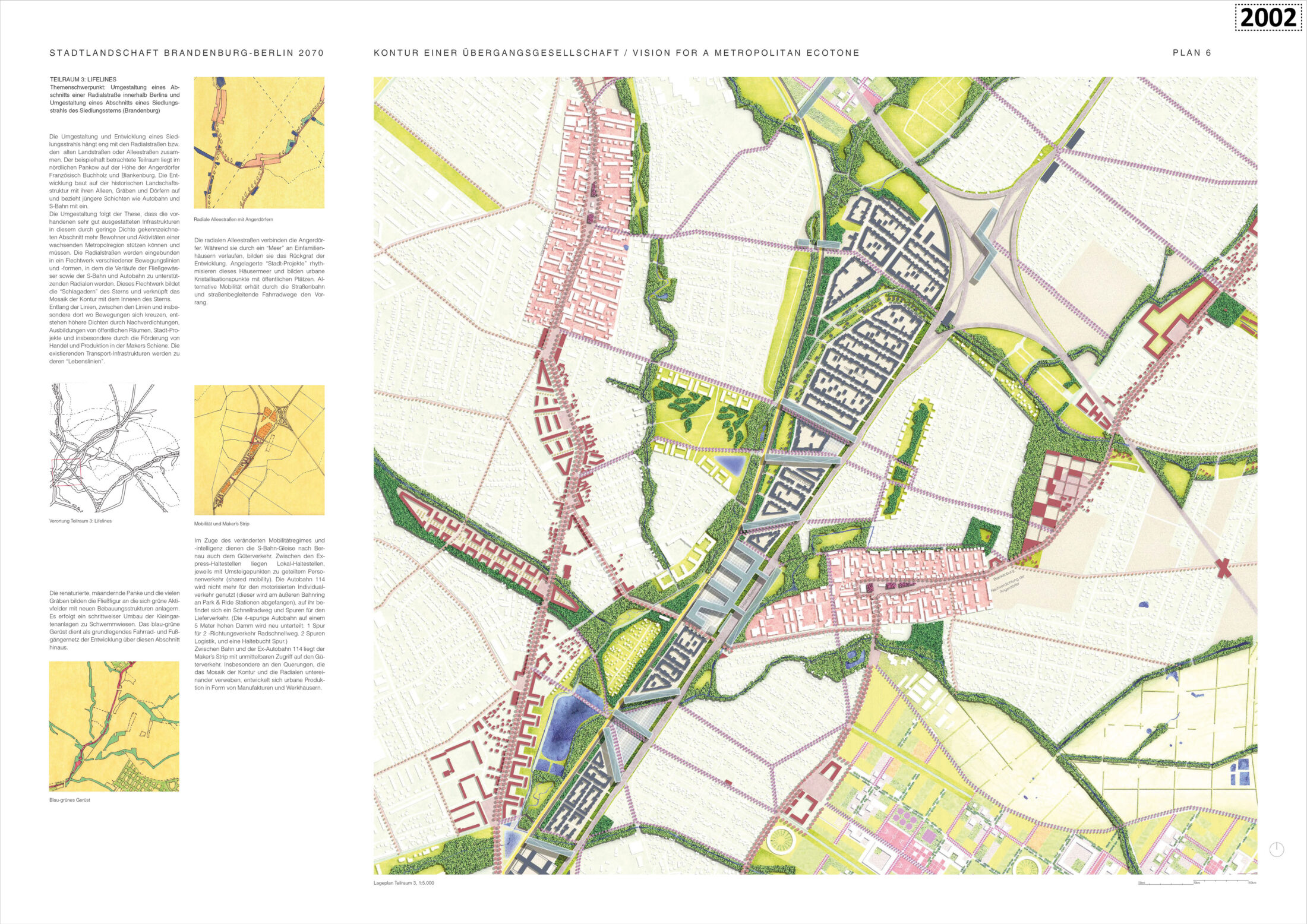
Lifelines, focus: redesigning a section of a radial street within Berlin; redesigning a section of an arm of the star-shaped settlement (Brandenburg). The sub-area considered as an example lies in northern Pankow near Französisches Buchholz and Blankenburg. The development builds on the historical landscape structure with its tree-lined avenues, ditches, and villages and includes more recent additions, such as the motorway and the suburban railway. The redesign is based on the principle that existing and developed infrastructures in this area, which is characterised by low density, can and should support more residents and activities in a growing metropolitan region. The radial roads are integrated into a network of various arteries and forms in which the waterways, motorway, and suburban railway become supporting radials. This network constitutes the arteries of the star-shaped settlement structure and links the contour’s mosaics with the star’s interior. Along the arteries, between the arteries, and especially where transport routes intersect, higher densities are created through densification, the formation of public spaces, city projects, and the promotion of local and regional trade and production. The existing transport infrastructures become their ‘lifelines’.
Bernd Albers / Silvia Malcovati / Günther Vogt Location: Berlin / Potsdam / Zurich www.berndalbers.com /www.silviamalcovati.com / www.vogt-la.com/ www.arup.com/offices/germany/berlin Team: M. A. Dan Dahari (project leader), B.A. Iveel Bold, Dipl.-Ing. Maren Brakebusch, Bess Laaring, Dr. Gereon Uerz,Dipl.-Ing. M. Arch Rudi Scheuermann, Ibrahem Alsalamh Landscape architecture: VOGT LANDSCHAFT GMBH Other specialist planning: Arup Deutschland GmbH
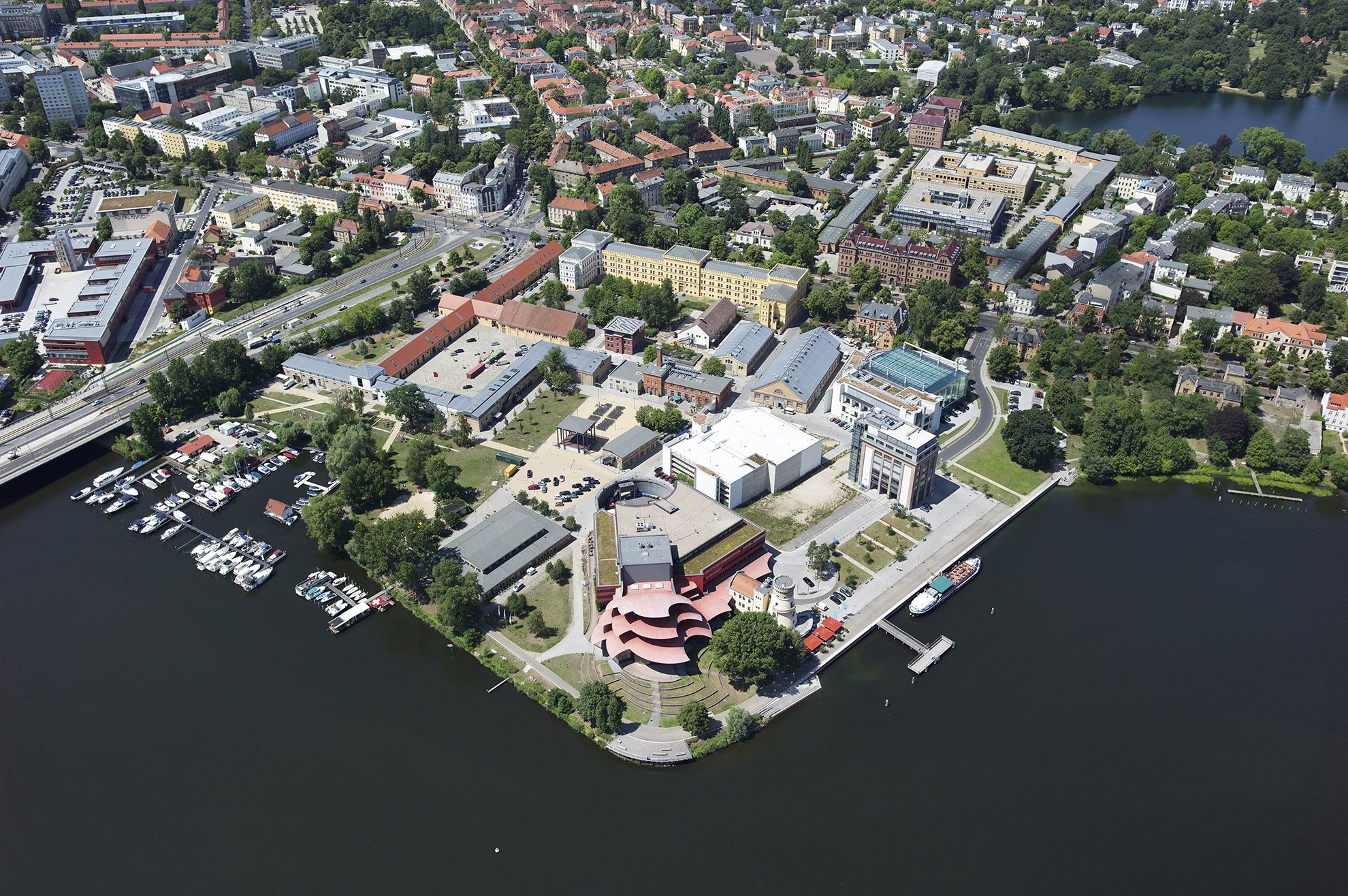
Sub-area 1: Tempelhof – Südkreuz
The area between Südkreuz and Tempelhofer Feld along the suburban railway line currently consists of abandoned commercial sites, railway facilities, allotment gardens, peripheral areas near the former Templehof Airport, and remaining areas surrounding the Südkreuz railway station. The A10 metropolitan motorway and the suburban railway ring dominate the urban situation. The design demonstrates how one can further develop these districts based on the existing nineteenth-century urban structure and clearly distinguishes it from the garden city of Neu-Tempelhof (also known as ‘Fliegersiedlung’ – ‘Aviation Settlement’). The buildings along the railway ring function as distinct urban borders. For the Aviation Settlement, the development proposal adheres to the proportions of the existing residential buildings in the sub-areas. The development along the railway line mixes housing, workplaces, and essential amenities. The additional buildings south of the airport building, like the building itself, accommodate cultural and research institutions. A group of three high-rise buildings marks the centre and forms a gateway to the south.
Sub-area 2: Bernau
There is great potential for urban development to the northwest and southeast of the Bernau railway station. Two conversion areas along the railway line, which penetrate into the surrounding landscape to the southwest, consist of settlements with transport infrastructure that are intended to initiate a new phase of mixed-use urban development. The proximity of the A10 and A11 junction and of inexpensive local, regional, and long-distance rail connections support the idea of urban expansion at this location. The concept foresees high densification here, in contrast to the existing districts. In the area surrounding the railway station, block structures have been developed that enclose the railway line and open to the north and south. To the northeast, the conversion area is lined with a series of U-shaped buildings that form a large-scale addition to Panke Park. The auxiliary functions in the southwest area are intended to support tourism and accommodate a wider range of recreational activities.
Sub-area 3: Schwedt an der Oder
The former royal seat of Schwedt an der Oder, which was badly destroyed in the Second World War, lies on the northeastern edge of the regional development plan. The town of Schwedt would benefit greatly from a rail connection along the existing Berlin–Stettin line. The design concept envisages establishing this connection and incorporating the central station area of Schwedt into a new urban mixed-use location. Gaps and remaining areas in the urban structure are filled, and new constellations are developed – based on the concept of critical reconstruction – to revive the historical city layout. A unique selling point is the landscape of the lower Oder Valley with its nature reserves and national park. Uniting the urban development more closely with the river landscape would not only strengthen the area around the Uckermark areal with the former royal palace but would also signify an upgrade for the entire city.
Entrant‘s description
Growing Together: The Landscape City Berlin and Brandenburg Will Grow Together
A future concept for the Berlin-Brandenburg metropolitan region not only requires cooperative political processes but must also include a master plan for the city and the surrounding countryside. This plan is based on historical considerations and on the existing potential and characteristics of the Berlin-Brandenburg urban and natural landscape.
Towns in Berlin and Brandenburg will expand inwards. Berlin has great potential for internal growth, densification, and spatial optimisation. This potential can be realised through the use of vacant lots and brownfield sites and through the transformation of existing infrastructures. Berlin’s green character must also be preserved, as it embodies a matchless legacy of urban planning and will be increasingly important for the area’s climatic balance in the future. Towns in Brandenburg also have much capacity for growth within their borders. This inner growth can preserve and bolster the particular characteristics of the state’s more urban areas. Railways will ensure future mobility and transport. Against the backdrop of climate change and the energy transition, the expansion of the road and motorway network is not a satisfactory solution for the future. In contrast, railway transport allows for a more sustainable future driven by the digital revolution. The future growth of the city will take place near new railway lines.
Berlin-Brandenburg and Europe The global shift towards sustainable modes of transport and the expansion of railway and water transport are turning the Berlin-Brandenburg region into a hub of diverse cultural and trade corridors in the German and European context. Accordingly, this railway and waterway network is undergoing continuous optimisation. Growth takes place along the radial axes and connects the towns and city. The urban expansion areas follow the star-shaped railway lines between the protected natural landscape and cultural landscapes, thereby transforming the scattered settlement areas into more compact urban structures. In this way, buildable land for one million new residents is gained without radically altering the character of the urban structure or disturbing the harmonious natural areas.
The Countryside Comes to the Towns The Berlin countryside is characterised by forests, lakes, and agricultural areas and harbours unique potential for the climatic and ecological regeneration of the region in the future. Strengthening the spatial connection between these areas and improving their incorporation into the growing and increasingly populous urban region is central to our concept. Natural and cultural landscapes will be boosted with the appropriate infrastructure and networks of paths for outdoor activities. Cultural landscapes reinforce the perception and appreciation of the region as an integrated entity and intensify the population’s connection with it, promoting empathy between the rural and urban residents.
The radial settlement arteries complement one another along the railway lines with their adjacent cultural landscapes. They reinforce Berlin’s star-shaped settlement structure and result in a coherent structure with complementary qualities: city, cultural landscape, and agricultural land. The third ring connects the radial arteries. We are adding a new third ring to the first and second rings to accelerate the connection routes between the towns on the outskirts of Berlin, thereby avoiding detours through Berlin. Because of the density and proximity of many towns in the north, east, and south, the third ring will also link these places; and the third ring will join the second ring to the west of Potsdam. This bypass optimises the internal dynamics of the second and third rings. The area inside Berlin’s first railway ring becomes the geometric centre of Berlin’s series of concentric transport rings. The third ring significantly increases mobility in the areas surrounding Berlin and reduces their dependence on the city. This ring will be realised in phases. The first segment will be built in the northeast, since the greatest added value is expected there, in coordination with the growth of Brandenburg’s centres. One can ensure the desired network optimisation, even when building the third ring in stages, by connecting it to the radial transport axes. Urban centres, composed of housing, commercial spaces, and social infrastructures, which will in turn benefit from optimal transport infrastructure, will emerge near the intersections of the rings and radial axes. Thus, Brandenburg’s growth areas near the third ring will see more opportunities to develop and connect with one other independently of Berlin.
The Third Ring as an Elevated Railway The third ring is conceived as an elevated railway in order to protect the cultural landscape, agriculture, and wildlife. This also simplifies intersections between roads, motorways, and rivers. Lightweight construction fosters a harmonious relationship with nature and agriculture. The elevated trains provide a pleasing view of the surrounding countryside, and the suburban train stations in the towns become attractive centres. We have selected three locations to illustrate the master plan. We analyse each location in terms of mobility, history, growth, and landscape. Two of the locations (Tempelhof-Südkreuz and Bernau) are situated at the intersection of radials and rings; the third location (Schwedt) is situated along a radial. Using these locations as examples, we demonstrate the characteristic features of the Berlin-Brandenburg region. These include: urban areas with contradicting histories; industries; diverse natural areas; good railway networks; and strong growth potential. Tempelhof-Südkreuz has always been an exceptional area as it has remained undeveloped and is characterised by railways, meadows, barracks, and training areas. Today, the neighbouring intersections of the first ring and railway radials (Südkreuz) and of the B96 motorway, the underground, and the urban motorway (Tempelhof) offer unique potential for urban development. Tempelhofer Feld is important as a recreation site and cold-air production area for the city centre. The optimal transport connections near Tempelhofer Damm make it ideal for large cultural projects in Berlin-Brandenburg. The former airport site could house a new state library, university campuses, and research centres. The areas along the railway will be mixed-use districts. The three prominent high-rise buildings at the junction of the B96 motorway, underground railway, and urban motorway make it an ideal location for a regional centre. The railway line is accompanied by a bike path, which enables fast journeys between the railway station and airfield. The urban motorway is ideal for future bicycle use. No longer isolated, Tempelhof-Südkreuz is now integrated into the urban landscape and fulfils an important function in Berlin. Bernau bei Berlin is a great example of a Brandenburg town with a colourful architectural history. The structure of the medieval wall and rampart continues to shape Bernau today. Socialist modernisation policies established in 1975 damaged but did not eradicate the fabric of the city centre. The railway runs from Berlin to the northeast, towards Szczecin and the Baltic Sea. The two military facilities testify to the importance of railway connections for the city. The construction of the third ring – and of the intersection with the north–south radial – will transform Bernau into a transport hub, which will promote the development of the areas near the railway station and the old town. The repurposed military complexes could accommodate new homes and research facilities. The renaturalisation of the Panke River and Panke Park nearby will allow residents to live surrounded by nature and enjoy optimal connections to other locations in the region. For regional tourism, the district of Barnim, starting from Bernau, offers an ideal point of departure, not least for tourists on bicycles. Three city models characterise Schwedt an der Oder: the medieval city (1265), the baroque city palace (1685) with its magnificent landscaped axis leading to the Mon Plaisir summer palace, and the model socialist city (Selmanagic 1960, Paulick 1962) built for the workers of the crude oil processing plant. Under the socialists, the city palace was destroyed in 1962 and replaced with the Palace of Culture. All three city models are in a fragmentary state today. Beyond the Oder lies a meadow landscape with one of more important bridges across the river. A railway line connects Schwedt, via Angermünde, to the radial axis running through Berlin, Stettin, and the Baltic Sea. We wish to optimise this connection, so that the radial axis will include a high-speed train from Berlin to Szczecin via Schwedt. This high-speed train will then continue along the Oder to the Baltic Sea. Appropriate city planning measures in Schwedt can bring together mobility, urban history, and nature to form a complementary and symbiotic relationship. It is possible to reanimate the three city models: by restoring the old town; by building around the castle near the theatre; by revitalising the green axis and the Mon Plaisir park; and by completing the town centre based on the socialist city model, with new buildings for research and tourist facilities. The new significance of the railway station will lead to urban densification and better transport connections. Former prefab building complexes will be renatured, and the alluvial landscape will be protected against development. These interventions and the growing regional tourism along the Oder, with its new port, municipal swimming complex, and national park, open up the best prospects for Schwedt, located on the railway line between the Baltic Sea and Berlin.
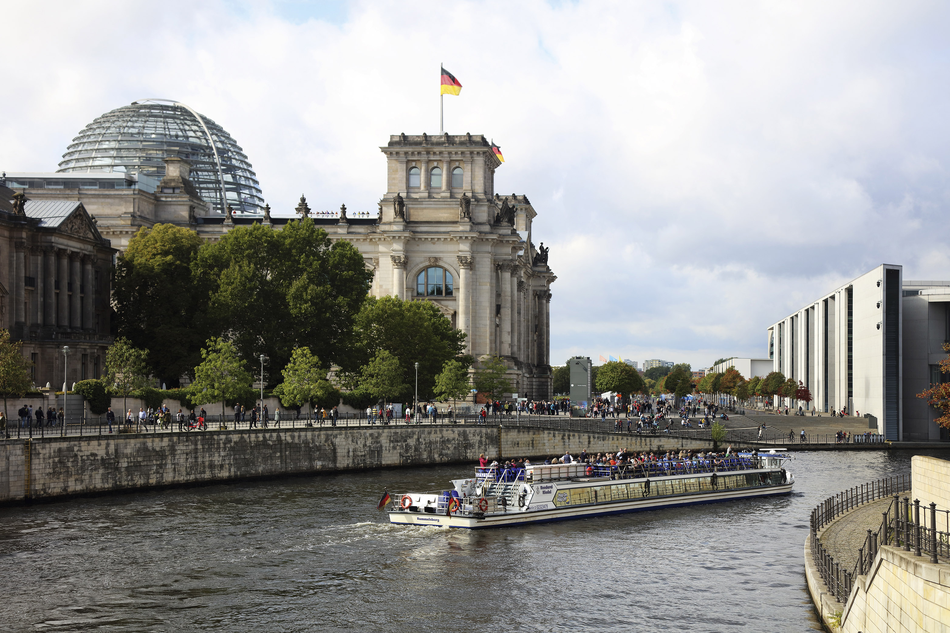
THE FEDERAL RIBBON OF GOVERNMENT BUILDINGS IN THE SPREEBOGEN DISTRICT The Spreebogen government district on the bend of the River Spree is the most important government location that Greater Berlin has ever had. It was the seat of the Reichstag parliament during the imperial era and became the centre of the Weimar Republic in the 1920s. It was also the planned site of the Great Hall, conceived by the Nazi leadership to be the largest building in Berlin and the centrepiece of the capital of the Reich. It became an outlying area in limbo when the city was divided, but is now home to a complex of government buildings, the state’s most visible presence in the capital. The Spreebogen district is the youngest of Berlin’s large government districts – much younger than the palace area and younger than the Wilhelmstrasse government quarter. It illustrates how the spatial focus of the state’s presence in Berlin has migrated westward. Photo: Philipp Meuser, 2020
In 1920, Berlin had been Germany’s capital for less than half a century. Unlike London and Paris, Berlin was a far cry from being the undisputed centre of a large European country. The city was more like Rome and Moscow, a young capital with a mixed reputation. The Greater Berlin Act of 1920 did not include any provisions that clearly regulated its status as the capital of the young Weimar Republic. Nevertheless, the state as a whole has been instrumental in shaping the development of the city since then. Today, federal projects influence public debate and, increasingly, the image of the capital. The state has made the city, much to either the joy or annoyance of Berliners – and has done so for centuries. The difference now is that the capital has become very popular abroad and is seen as a cheerful and tolerant city in a country that is often underappreciated. Berlin has another anniversary coming up in 2021: 150 difficult years as the German capital.
A state’s global standing and economic performance largely depend on the beauty and the prestige of its capital. […] Germany and its importance in the world are judged on the impression that the imperial capital makes on other countries. […] Berlin does not view its tasks from a local perspective, but rather from the point of view of the whole of Germany.
Tourist advertising for Berlin (has) to reckon with the empire’s tense hostility towards Berlin. […] Berlin is like New York in the United States. People admire its rapid growth, but can’t quite come to love it yet. One of the main aims of Berlin tourism advertising is to dispel prejudices against the capital.
Gustav Böß, mayor of Greater Berlin from 1921 to 1929 Berlin Today, Berlin 1929
Locations for Parliament and Government
In 1920, the state’s presence in Berlin was centred in three locations that defined the city: Hohenzollern palace, which was actually a Prussian building; Wilhelmstrasse, a symbol of governance; and Königsplatz, the seat of the Reichstag and the German state’s most powerful building in Berlin. The palace was a masterpiece of architecture that had evolved over centuries, but by the late nineteenth century, it had long since lost its role as the sole centre of power. Wilhelmstrasse rose to become the official government headquarters of the new empire and became a synonym for the German government. When the General Staff building was built between 1867 and 1871, it became the ‘soul of the army’ and marked the beginning of government building moving into the Spreebogen area around the bend of the River Spree. Building in the area reached its peak with the construction of the Reichstag between 1884 and 1894, and this also marked the end of construction in the period.
The Spreebogen District
No other area of the city conveys the brutal history of the state’s presence in Berlin as vividly as the Spreebogen district. It has been the seat of republican, dictatorial, allied and now democratic rule in the city.
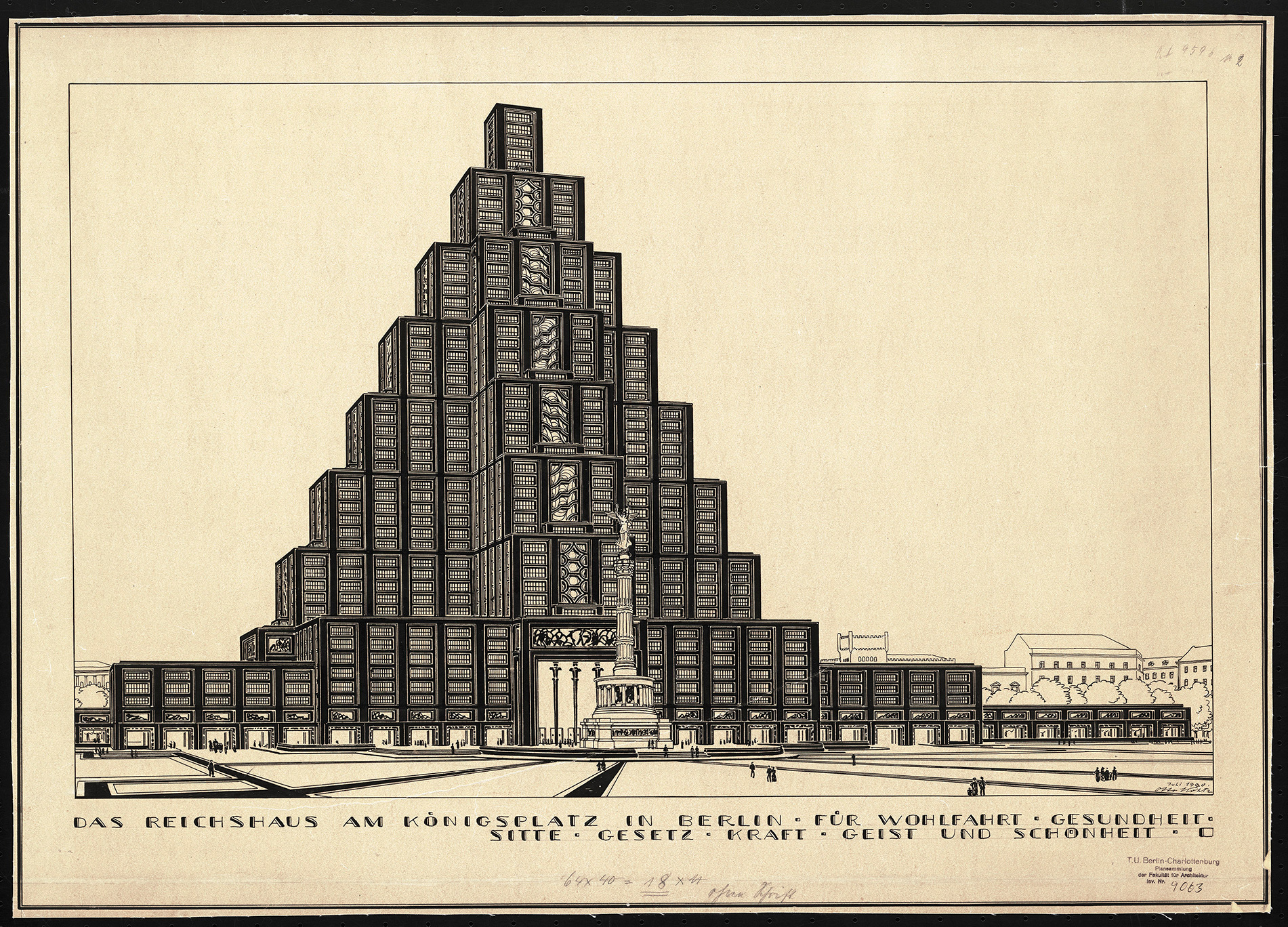
Otto Kohtz’s design for the Reichshaus building at Königsplatz in 1920. The monumental, pyramid-like, multi-storey office building was intended to provide space for Reich authorities. AM TUB, no. 9063
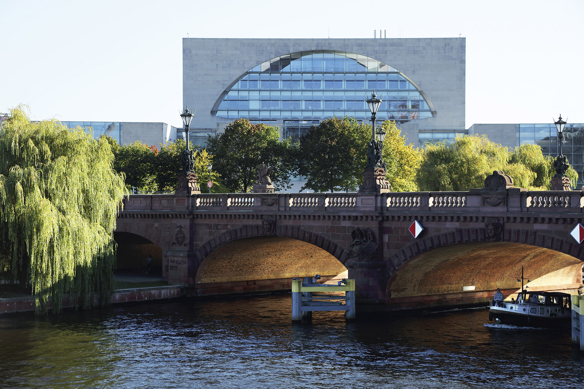
The Federal Chancellery in 2019. Some Berliners refer to it as the ‘washing machine’. Moltkebrücke bridge is visible in the foreground. Photo: Thomas Spier, apollovision
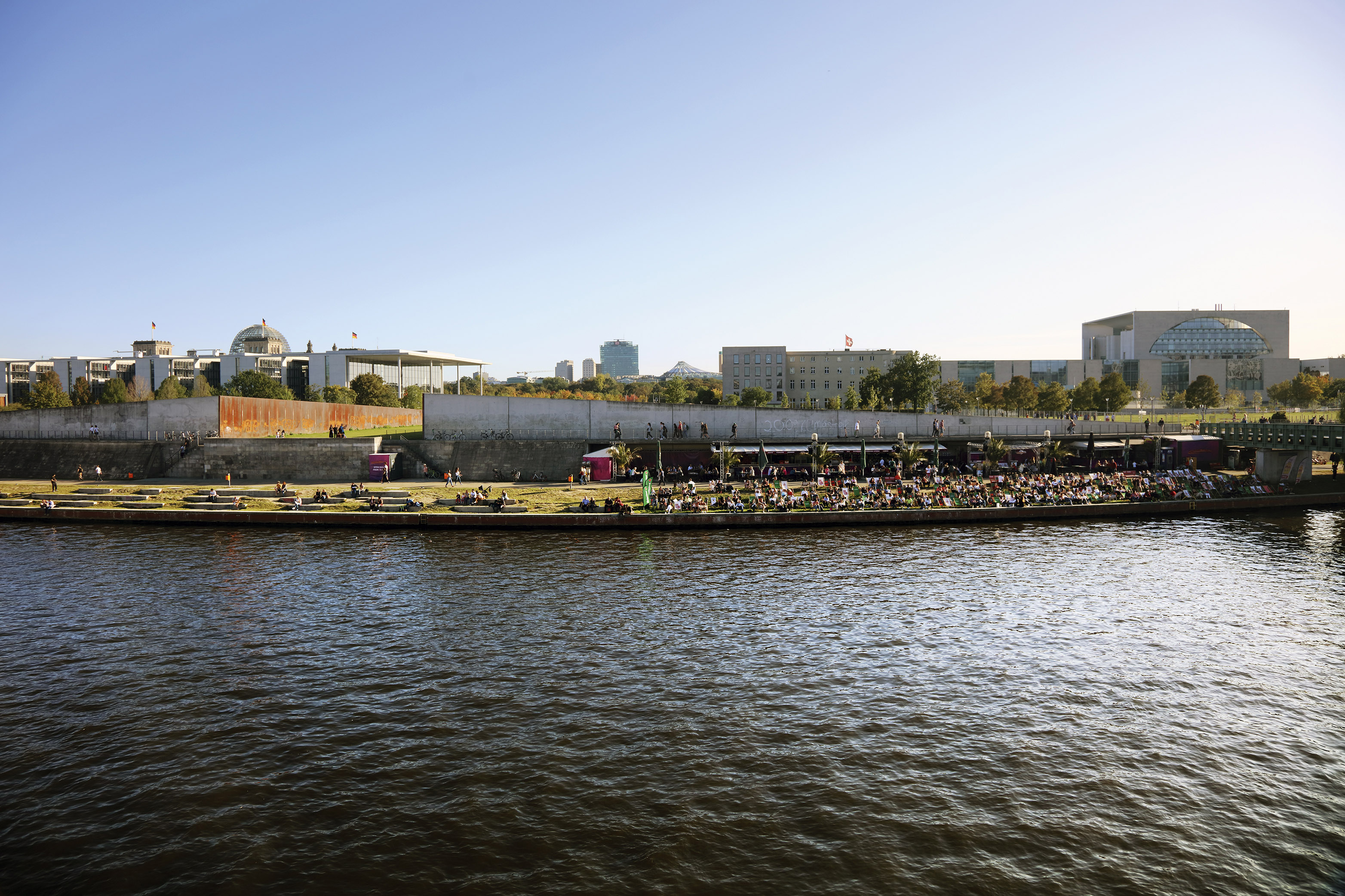
The River Spree in 2019. There is a popular city beach on the southern bank of the river, downriver from the Federal Chancellery, the Swiss Embassy and Paul Löbe House. Photo: Thomas Spier, apollovision
The new Reichstag, seat of Germany’s federal parliament, pictured from the Marschallbrücke bridge in 2019. Photo: Thomas Spier, apollovision
Wilhelmstrasse
During the imperial era, many people began to notice a distinction emerge between a western ‘imperial side’ and an eastern ‘Prussian side’ of the Wilhelmstrasse government precinct. After the Second World War, the headquarters of the East German government was located here – in the state’s most important building.
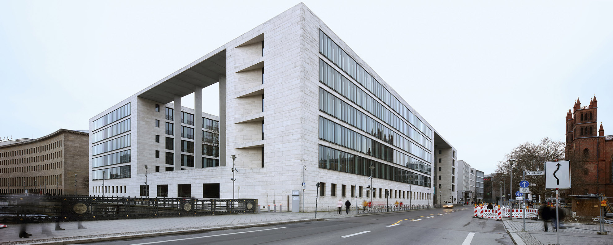
The Federal Ministry of Finance, formerly the House of Ministries, pictured in 2019. The building’s eventful story continues: It has been the headquarters of the Federal Ministry of Finance since 1990 and was renamed Detlev Rohwedder House in 1992 in honour of the head of the Treuhandanstalt trust agency assassinated by the Red Army Faction (RAF). The Federal Ministry of Building considered demolishing the large building towards the end of 1992. Photo: Thomas Spier, apollovision
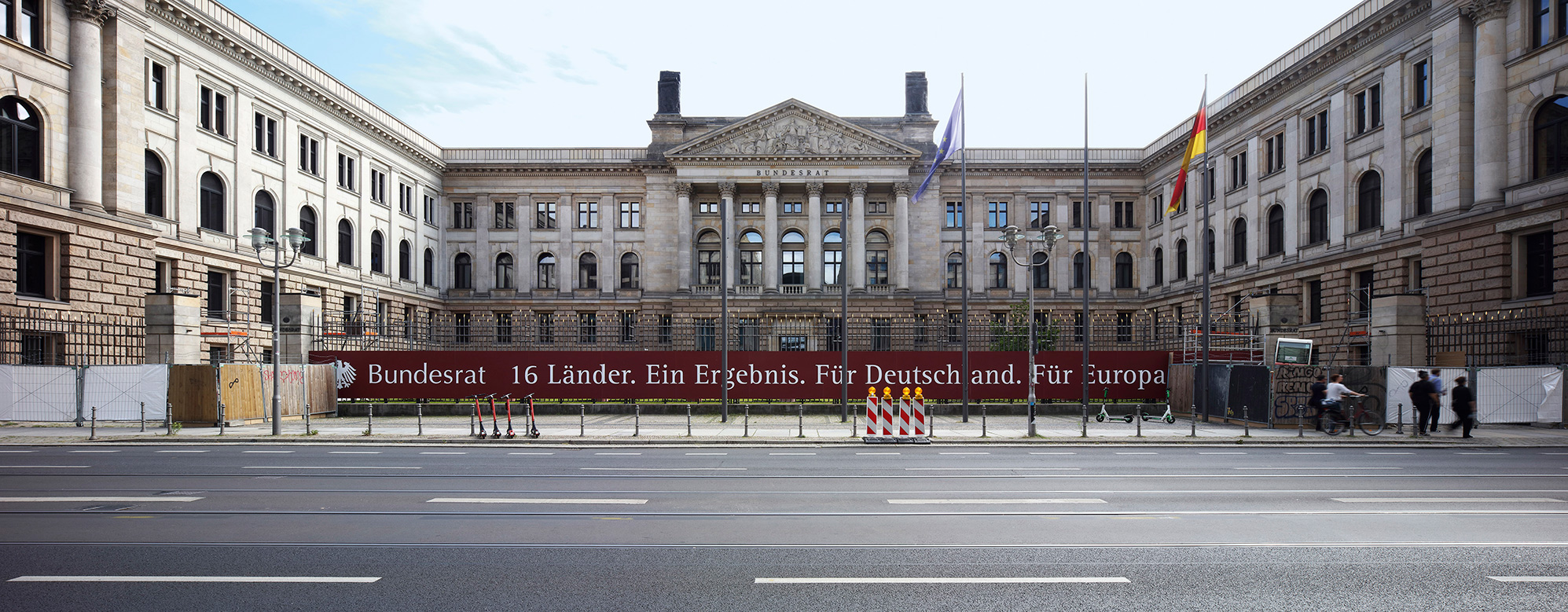
The Federal Council building on Leipziger Strasse, near Wilhelmstrasse, pictured in 2019. Built in 1904, it served as the seat of the first chamber of the Prussian parliament until 1918 and was the headquarters of the Prussian State Council during the Weimar Republic. The building was assigned to the Ministry of Aviation during the Nazi era. The Federal Council moved in in 2000. Photo: Thomas Spier, apollovision
Berlin Palace
Berlin Palace ceased to serve as a seat of power at the end of the war and the empire in 1918. It has primarily served as a museum since the 1920s. The ruins of the palace were demolished in 1950 during the German Democratic Republic (GDR) and a state forum was built in its place. The palace is currently being resurrected as the Humboldt Forum, which has proven to be extremely controversial.
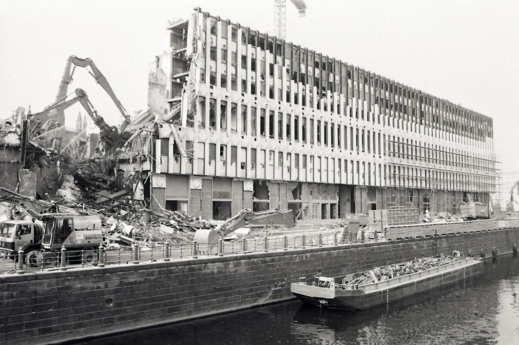
The Ministry for Foreign Affairs of the German Democratic Republic was built according to plans designed by Josef Kaiser and others between 1964 and 1967. It was demolished in 1995 / 1996. Photo: Jacob Stefane;Berlin State Archive, F Rep. 290 no. 377231
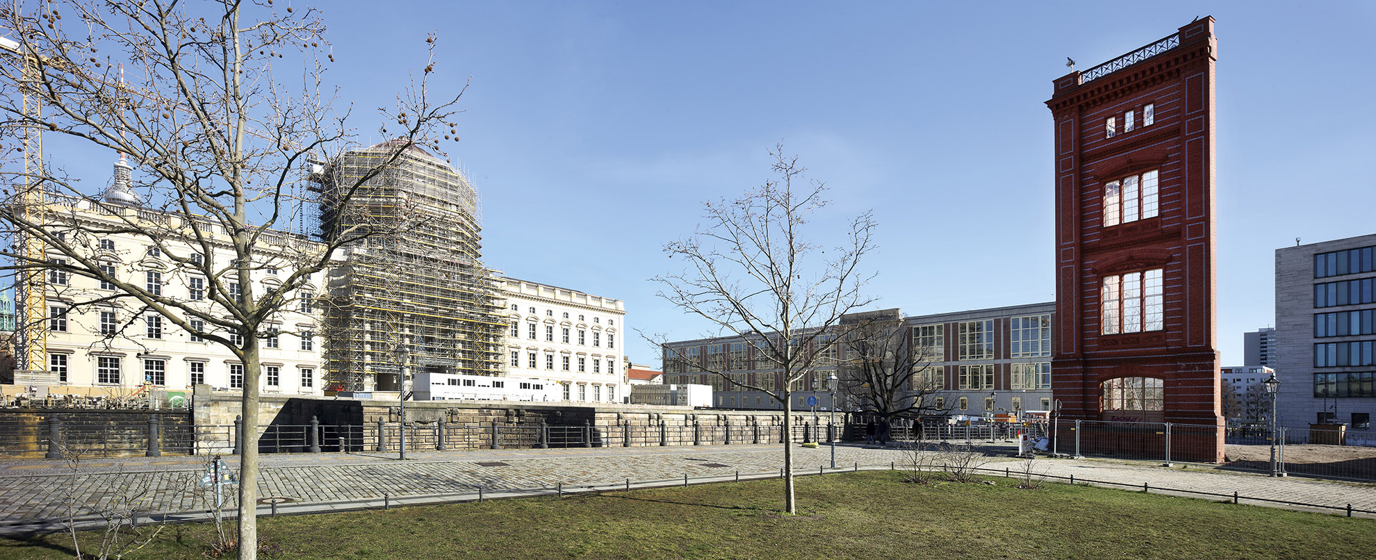
The Humboldt Forum in 2020. Scaffolding still surrounds the main entrance and cupola. The forum is set to open in stages beginning in September 2020, but it was announced in May 2020 that the opening would be postponed due to the coronavirus pandemic. Photo: Thomas Spier, apollovision
The Federal Foreign Office building, pictured here in 2020, was designed by Thomas Müller Ivan Reimann Architects and built between 1996 and 1999. The new building was built onto the front of the prominent old building, extending the former Reichsbank building, which was designed by Heinrich Wolff and built between 1934 and 1940. This early example of Nazi architecture became the seat of the Central Committee of the Socialist Unity Party of Germany in 1958, making it the centre of power of the East German state. Photo: Thomas Spier, apollovision
Gifts for All: Cultural Buildings
The state built the capital both for itself and to enrich our culture in general. Among the gifts from the federal government are the new Building Academy, the Museum of Design for the Bauhaus Archive, the Monument to Freedom and Unity, the Humboldt Forum and, of course, the Museum of the Twentieth Century at the Kulturforum. These gifts have not always been welcomed and many are controversial, but all in all, they enrich the city.
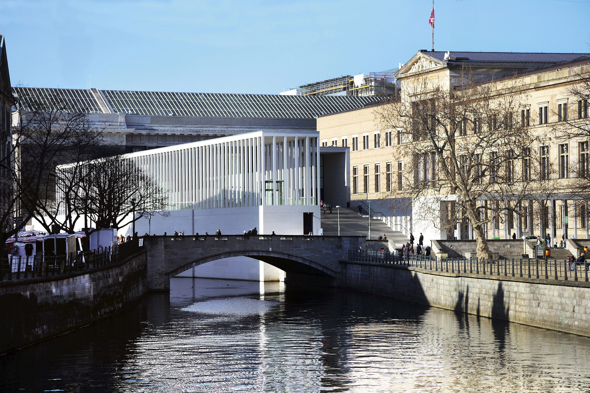
Museumsinsel in 2020. The James Simon Gallery became the final component of the UNESCO World Heritage Site in 2018. The new building acts as a link between the five museums on the island. It was designed by David Chipperfield Architects, which was also responsible for restoring and renovating the New Museum. Photo: Thomas Spier, apollovision
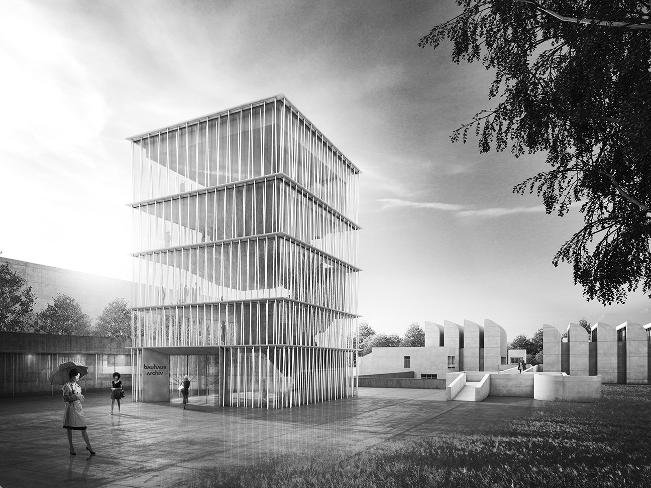
The Museum of Design for the Bauhaus Archive is planned to be completed in 2022. Staab Architekten won a competition in 2015 with a design composed of a striking tower, a series of underground museum and event rooms that connect the old and new buildings, and a sunken garden. Staab Architekten
The reconstructed corner of the new Building Academy, pictured in January 2020. The academy suffered only minor damage during the Second World War, but was demolished in 1961 ⁄ 1962 for the benefit of the Ministry for Foreign Affairs of the German Democratic Republic. The original building was designed by Karl Friedrich Schinkel and built between 1832 and 1836. It was a forerunner of the Technical University of Berlin. There has been a long debate about the design and use of a new building and as a result, it will be ‘as much Schinkel as possible’. Photo: Thomas Spier, apollovision
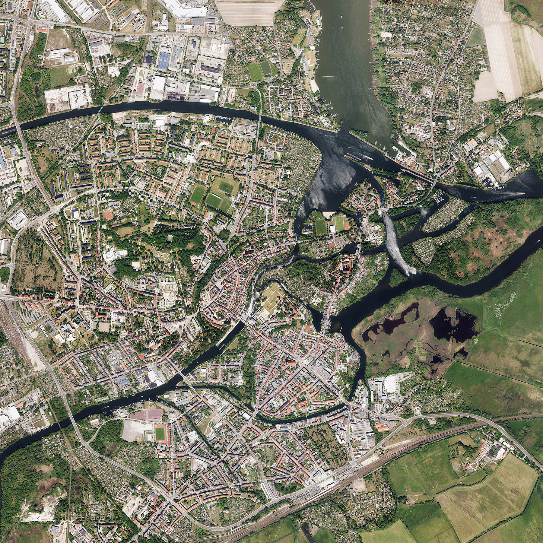
BRANDENBURG AN DER HAVEL: FORMER CAPITAL OF THE MARGRAVIATE OF BRANDENBURG A former city of the Margraviate of Brandenburg and the current state capital: Brandenburg an der Havel in 2017. The aerial photo shows the old town, the new town and the cathedral island district (Dominsel). An abundance of water flows in what was the most important medieval city in the greater Berlin and Brandenburg area. GeoBasis-DE / LGB, dl-de / by-2-0
Berlin is more than just the city. After the Thirty Years War, Friedrich Wilhelm, the Great Elector, expanded his new residence in the Margraviate of Brandenburg. There were already palaces in Oranienburg and Potsdam, and Charlottenburg Palace was soon added to their number. However, the Prussian kings mainly focused on developing Potsdam and they formed a unique complex of palaces and parks in the city southwest of Berlin. While Potsdam has historically been seen as the daughter city of Berlin, Berlin’s mother city has largely been forgotten: the capital Brandenburg an der Havel, which was a city of the Margraviate of Brandenburg. It was the most important city in the region until the fifteenth century. There are other unique cities in Brandenburg, too. Whether in the immediate or more distant vicinity of Berlin, the state is full of emerging towns with long histories, and they all deserve far greater attention. All of these cities and towns in Brandenburg have long been part of the metropolis of Berlin. Their design shapes our shared future.
Berlin’s economy and transport network stretch far beyond the city limits. Greater Berlin extends out to the Nauen line, a circle of towns that surrounds Berlin and encompasses Oranienburg, Bernau, Strausberg, Fürstenwalde, Königs Wusterhausen, Zossen, Seddin, Werder and Nauen. It has an estimated area of 250,000 hectares and a population of 4.75 million.
Berlin is home to countless people working in industries based outside the city. At the same time, large numbers of people living outside Berlin commute into the city for work. They live in Potsdam, Borgsdorf, Birkenwerder and Königs Wusterhausen, among others. The economies and people of Berlin and the province of Brandenburg are closely connected.
Berlin faces a serious constitutional problem in creating a link between the Berlin city administration and the Brandenburg provincial administration. The political borders of the imperial capital don’t match the reality on the ground. The economies and traffic networks of Berlin and the province of Brandenburg are inextricably intertwined.
The Berlin city administration and Brandenburg provincial administration cannot work side by side; they must work together. Merging is in the best interests of both parties. […] With goodwill on both sides, it will be possible to find a way to work together.
Gustav Böß, mayor of Greater Berlin from 1921 to 1929 Berlin Today, Berlin 1929
A Mother to Berlin: Brandenburg an der Havel
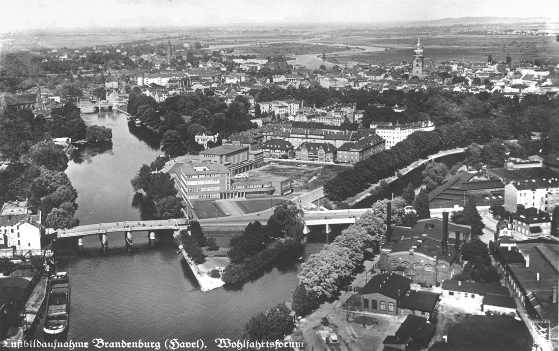
Brandenburg an der Havel is not just any town. Located to the west of Berlin, it is the oldest city of the former Margraviate of Brandenburg and it served as its capital until the late Middle Ages. The town is something of a mother to Berlin and a grandmother to Potsdam. It has three distinct residential areas: the old town, the new town and cathedral island. The three large churches and other medieval buildings testify to its importance. Brandenburg an der Havel became an industrial city in the last third of the nineteenth century. It was a centre of the architectural movement known as Neues Bauen, or New Objectivity, during the Weimar Republic. The old town, which had fallen into a chronic state of decline at the time of German reunification, underwent a successful urban regeneration programme and has been returned to its former glory. Today, Brandenburg an der Havel is one of seven cities in ring of cities that surrounds Berlin.
The Welfare Forum was built between 1929 and 1930 according to plans designed by Karl Erbs and Willi Ludewig. The forum consisted of an administration and therapy building for a health insurance company, a gymnasium and a swimming pool. The plans to build a school and apartment blocks were never carried out. The Welfare Forum was a model of local urban development and a shining example of the New Objectivity architectural movement. Photo: Heiko Hesse, Brandenburg an der Havel
A Daughter of Berlin: Potsdam
Potsdam is many things: a work of art, a paradise, an Arcadia of the North. It’s history is closely linked to the House of Hohenzollern, and a sovereign ruler once resided here. Once a garrison city, today Potsdam has a multicultural population. It’s a young city, only beginning to gain in importance in the seventeenth century. It’s hard to imagine another German city that has been more heavily influenced by its links to royal power. The city ceased to serve as a residence of the Hohenzollern family in 1918 and lost its status as a garrison city in 1994. What makes the state capital of Brandenburg special today? The city has become an internationally recognised urban ensemble made up of different layers. Its palaces and gardens are a World Cultural Heritage Site designated by UNESCO. What’s more, it is a city of culture, education and science, all of which enrich it in an extraordinary way.
An undated photo of Potsdam’s Old Market Square. The now demolished university of applied sciences is on the left. Small-scale buildings based on historical models stand in its place. IRS (Erkner) / Scientific Collection, D1_12_2-003
Potsdam: City of Science
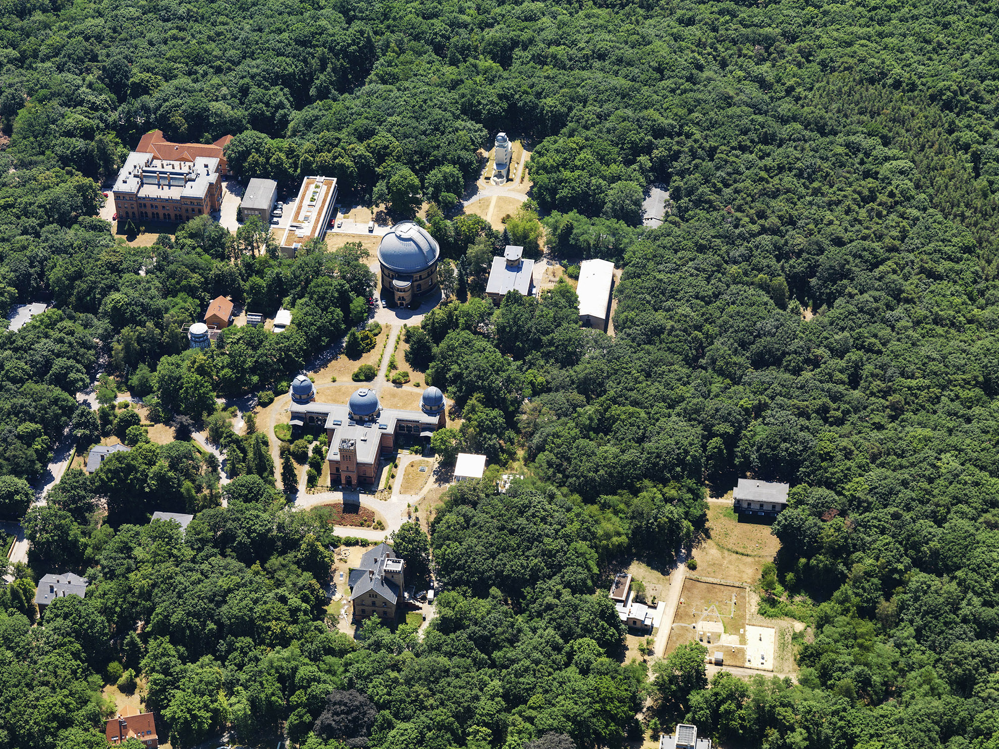
A photo of Albert Einstein Science Park on Telegrafenberg hill in Potsdam from 2010. Numerous scientific facilities have been established at the park, with some dating as far back as 1874. Today it is home to internationally renowned institutes for climate and geoscience research. Photo: Philipp Meuser
Potsdam’s reputation as a centre of science was established in the late nineteenth century thanks to the scientific facilities located at Telegrafenberg hill. Following reunification, the facilities were further expanded, including those in the city’s Golm and Babelsberg districts.
Potsdam: City of Culture
The cultural quarter borders the Tiefer See, pictured here in 2011. The Hans Otto Theatre, the headquarters of the Federal Foundation for Building Culture and many other cultural institutions can be found here. Photo: Philipp Meuser
Art, theatre, film and music: In the years since reunification, Potsdam has developed into a centre of culture with institutions of national and international renown. Many are located in the city’s cultural quarter.
Potsdam: A City to Live in
A residential complex at Schillerplatz, painted by Hans Klohß in the 1930s. The complex was developed by the WBG housing cooperative, which was founded in 1935. The city promoted the construction of the 400 small apartments, absorbing the construction costs and selling the land for a low price. Potsdam Museum – Forum for Art & History
Potsdam has long been a special address. The city has been shaped by its residents and indeed by soldiers based there when it was a garrison city. It’s been a multicultural city since its earliest days, with immigrants settling in ethnic enclaves. More diverse communities have developed in the years since reunification.
A Small Town on the Outskirts: Hohen Neuendorf
Hohen Neuendorf sits between Birkenwerder and Frohnau in the Oberhavel district of Brandenburg, north of Berlin. The town was first documented in 1349 and was drawn into the growing city at the end of the nineteenth century after the construction of the Berlin Northern Railway. Hohen Neuendorf underwent significant development in the early years of the Nazi era and a new train station on the outer railway ring was built in the town during the German Democratic Republic. The town’s population grew significantly after reunification. Hohen Neuendorf’s most remarkable architectural feature is the collection of special buildings at the intersection of the arterial road to Oranienburg and the road to the S-Bahn station. The town hall, pagoda, Hotel Turm and shopping centre are all located here.
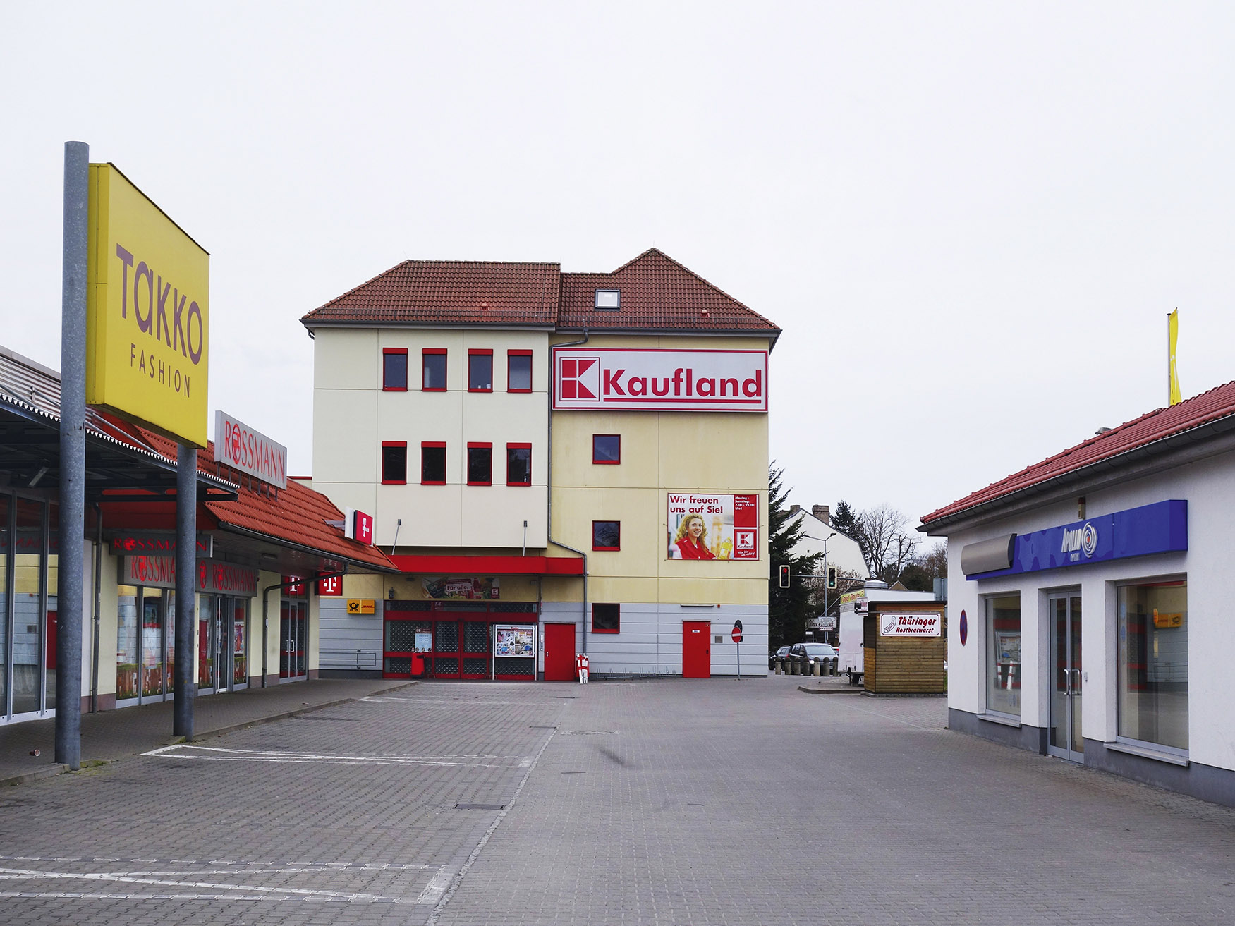
This open-air shopping centre is located in the heart of Hohen Neuendorf, just south of the town hall. It opened in 2006 and is pictured here in 2019. Photo: Harald Bodenschatz
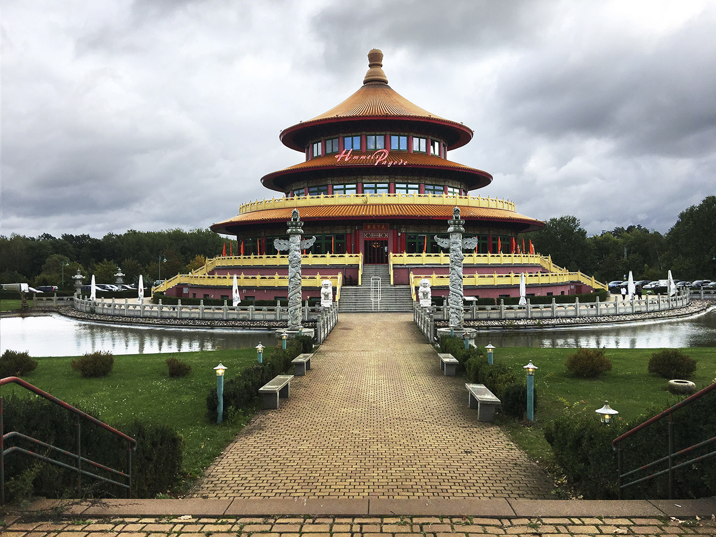
The Himmelspagode Chinese restaurant opened in 2002 and is pictured here in 2019. The building was modelled after the Temple of Heaven in Beijing and attracts visitors from across the region. It is located to the north of the town hall. Photo: Harald Bodenschatz
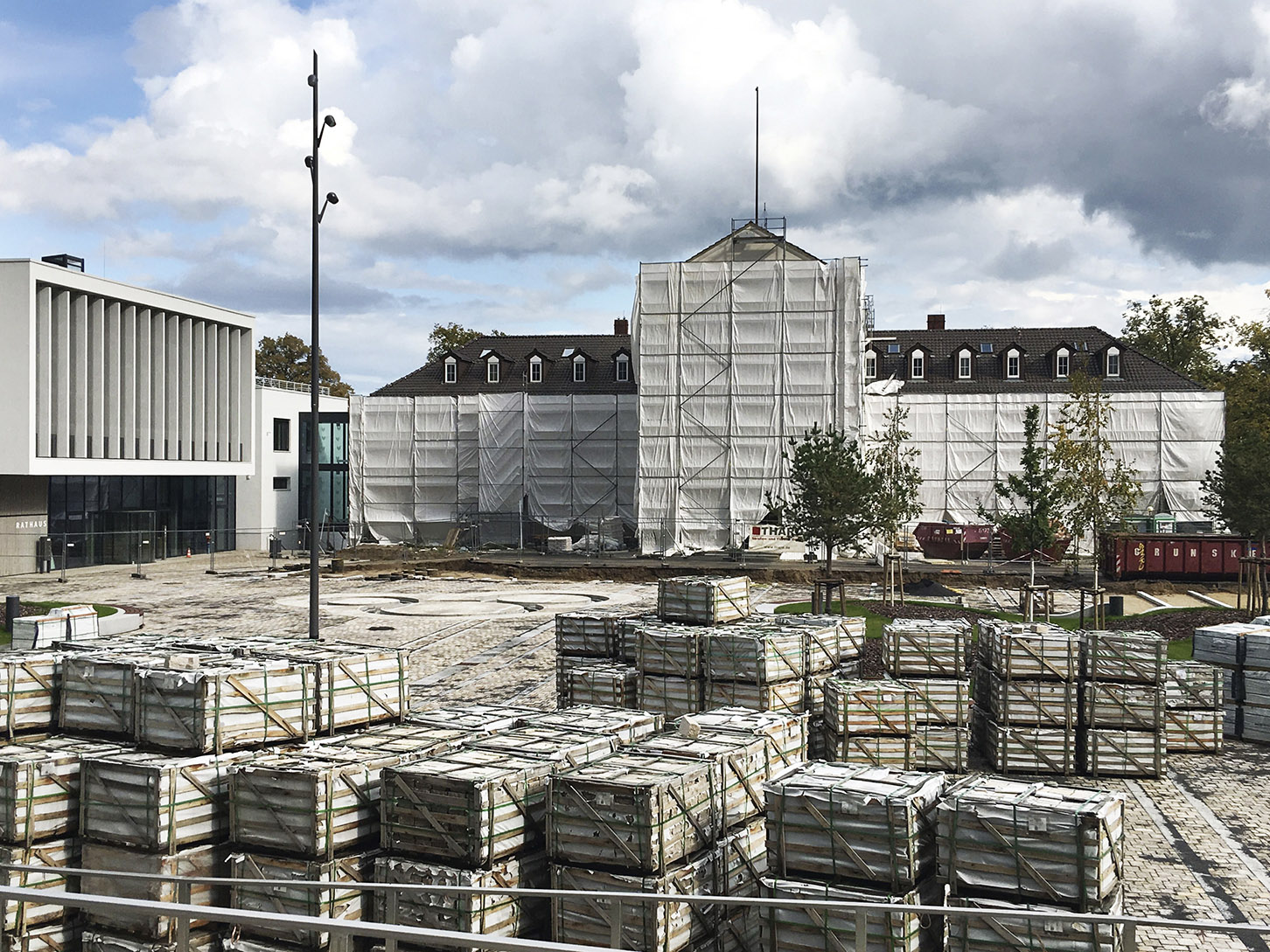
The construction site of the new town hall complex in September 2019. The existing edifice is visible in the centre of the photo and the new town hall is on the left. Other buildings forming part of the complex and the open spaces surrounding it are set to be completed in 2020. Photo: Harald Bodenschatz
A New Life for Military Facilities
There is nowhere in Germany in the twentieth century with as many military facilities as the Berlin-Brandenburg region. Military facilities began to concentrate here in Prussian times and the number of facilities reached a first peak during the imperial period. A new peak was reached during the Nazi era and after the war, the region continued to be used as a major base for the Soviet army during the German Democratic Republic. It is estimated that around 100,000 hectares of land became available when Russian troops left Germany in 1994. Potsdam, Wünsdorf, Kummersdorf, Döberitz, Bernau, Beelitz and numerous other places in Brandenburg all had large military bases. A large portion of this land has now been repurposed into recreational areas, technology centres, social infrastructure facilities and, increasingly, housing. What were once barracks are now homes!
A vacant barracks building in Krampnitz in 2017. The listed barracks buildings from the 1930s are to be converted into residential buildings. Photo: André Winternitz, rottenplaces
The ruins of the former army uniforms office complex in Bernau in 2019. The complex was built between 1939 and 1942 and used by the Wehrmacht to produce and store uniforms from 1941 to 1945. After the war, Soviet forces used the facility as a supply depot. The main warehouse at Schwanebecker Chaussee is pictured here. Photo: Harald Bodenschatz
The former army uniforms office complex in Bernau in 2019. The vacant wasteland is located right next to the A11 motorway. Photo: Harald Bodenschatz
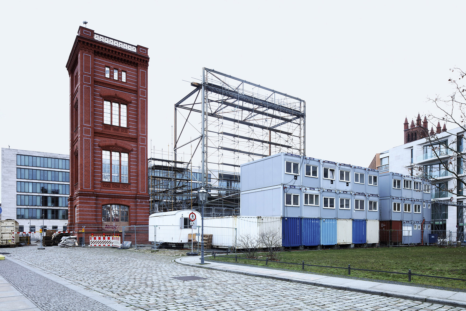
The Pankebogen development on Schönfelder Weg under construction in September 2019. A small part of the park, which is yet to be designed, is visible in the foreground. It will extend along the Panke river between the old town and the new residential development. Photo: Harald Bodenschatz
Rural Charm
Brandenburg has many historical cities and military areas, but it also has unforgettable rural areas, including many on the outskirts of Berlin. Its villages, transport infrastructure, agricultural areas, recreational areas, commercial areas, water reservoirs and wind turbines are all shaped by the local environment. Urban and rural are not mutually exclusive, no more so than Berlin and Brandenburg are.
The Water Landscape: It’s Not Just for Recreation
The importance of a city’s surrounding area for the water supply has long been underestimated. Climate change, longer periods of drought and heavy rain storms have brought the importance of water, and indeed safeguarding drinking water, to the fore in Europe.
Aerial photo of the Münchehofe waste-water treatment plant in 2019. The plant is a pilot project for energy-efficient water treatment and is operated by Berliner Wasserbetriebe, Berlin’s water supply and waste-water disposal company. Photo: Robert Grahn; Euroluftbild, no. 427645
Around 1900, attempts began in Europe to reorganise large and rapidly expanding urban areas, politically, administratively and in terms of planning. This was an extremely difficult process, and not just in Berlin, where efforts were hindered by conflicting interests and so rarely successful.
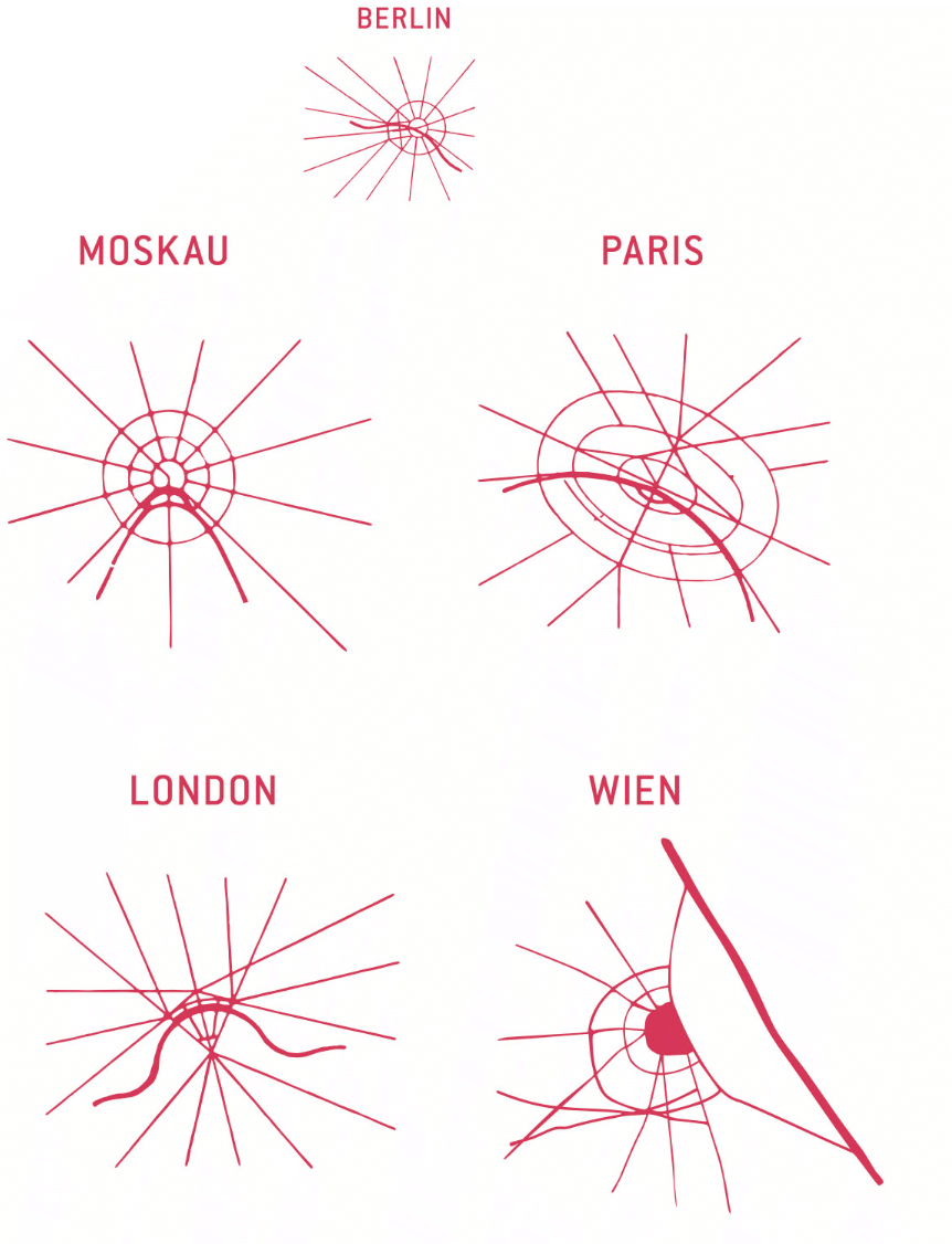
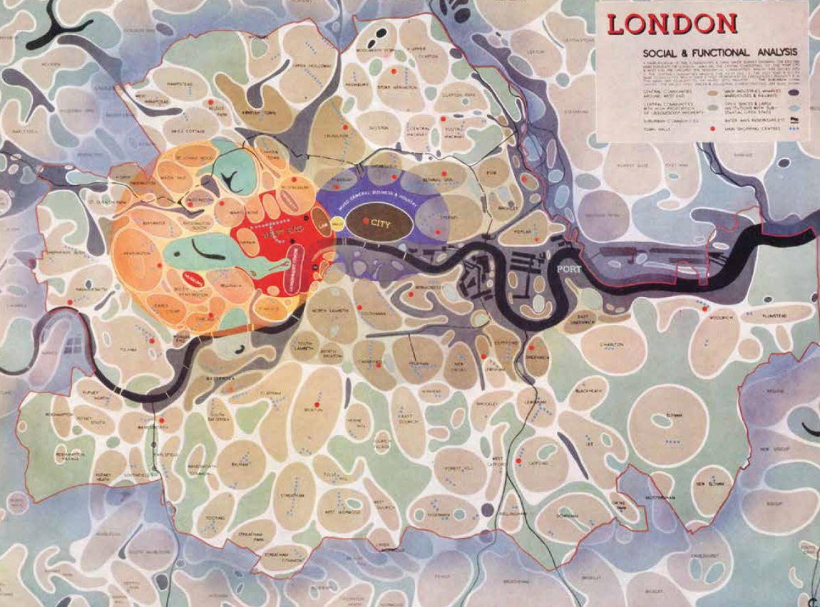
There are four main periods during which these attempts were pronounced. One: before the First World War, when metropolitan regions became a reality on a larger scale for the first time in history. Two: in the 1930s and during the Second World War, when democracies embarked on large-scale concepts under difficult conditions and hegemonic dictatorships set their sights on massive growth in their capitals. Three: in the 1960s, when suburbanisation was in full swing. And four: today, at a time when large, growing cities have to look towards a sustainable future. Here, four European capitals are of particular interest: Moscow, Vienna, Paris and London. All have been involved in the administrative development and urban planning of metropolitan regions for more than 100 years and are still wrestling with such issues today. In the following pages, there is an overview of the history, programmes and practice of urban planning in their metropolitan areas.
While Greater Vienna and Bol’šaja Moskva, like Greater Berlin, are unified municipalities, Grand Paris has remained an unrealised administrative project to this day. Greater London is not a unified municipality, but a regional association of 32 boroughs and the City of London, each of which of has limited powers as it is under the leadership of the Greater London Authority.
The above diagrams of the urban areas of Berlin, Moscow, Paris and London correspond to those published in 1938 in the grand photobook Moskva Rekonstruiruetsya (Moscow under Reconstruction). The authors of the 1938 versions were likely Aleksandr M. Rodčenko and Varvara F. Stepanova. However, the diagrams can be traced back to Eugène Hénard’s sketches, which he had published in Études sur les transformations de Paris (1903–1906), although there is no mention of this in the Soviet publication. They were then also printed in 1909 in Daniel H. Burnham and Edward H. Bennet’s book The Plan of Chicago and in 1911 in Werner Hegemann’s volume Der Städtebau nach den Ergebnissen der allgemeinen Städtebau-Ausstellung in Berlin nebst einem Anhang: Die Internationale Städtebau-Ausstellung in Düsseldorf 1910 – 1912 – a sign of the high esteem in which these sketches were held, as well as of the international networking within the discipline of urban planning.
The diagram of Vienna was redesigned based on historical sketches by Lilja Schick.
Bol’šaja Moskva (Greater Moscow) Capital Region between Europe and Eurasia
Moscow is a city with wide vistas and long thoroughfares, but it’s rarely possible to make out the city’s historical structure. It looks very different on the map: There are five concentric rings around the centre, where the Kremlin is located, and they look almost like a matryoshka nesting doll cut in half horizontally. The innermost ring circumvents the Kremlin. Travelling in a clockwise direction, it goes through the Kitay Gorod neighbourhood in the historic quarter, past Zaryadye Park and along the high Kremlin walls that face the Moskva River. The Boulevard Ring is incomplete in the south, as it forms a semicircle from one river embankment to another, and it is crossed by a boulevard in the middle. The officially designated Third Ring was only completed in the 2000s and runs roughly parallel to the 54-kilometre-long Moscow Central Circle, which served as the border of the city until 1960 as the Moscow Little Ring Railway. Further out, the Moscow Automobile Ring Road (Moskovskaya Koltsevaya Avtomobilnaya Doroga or MKAD) dates from the early 1960s and encircles the city. It is over 100 kilometres in length. From here you can see how densely built up Moscow is. Tower blocks and monumental prefabricated suburbs fill the horizon. The Kremlin forms the core of this oversized matryoshka doll. It is symbolic of the lighter and darker sides of Russia: Joseph Stalin, Nikita Khrushchev and Leonid Brezhnev – still considered heros by some – led the Soviet people for seven decades from inside its historic walls; now it is an attraction for legions of tourists with cameras in hand trying to capture the magnificence of old and new Russia.
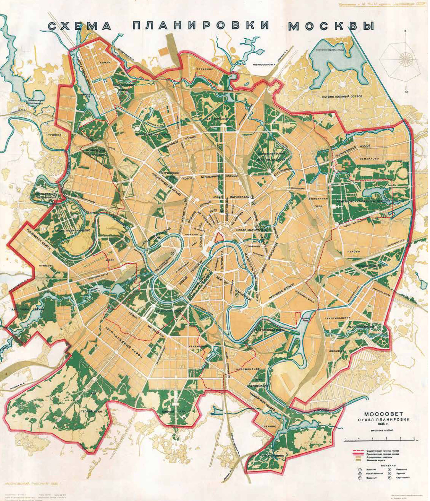
General Plan for a City of Millions: Moscow from 1935 to 1941
The second Five-Year Plan saw Joseph Stalin fundamentally change the approach to urban development and housing priorities from 1933 onwards. Building new industrial cities fell by the wayside in favour of expanding Moscow as the capital of the Soviet Union and the global communist movement. The General Plan of Moscow adopted in 1935 reflects this development. It was geared towards tremendous urban growth. The metropolitan area grew from 28,500 to 60,000 hectares. The southwest of the city was identified as the most important development area for housing construction. The vast new city was to be surrounded by a green belt made up of forest parks. The opening of the first metro line in 1935 was one of the highlights of the city’s urban redevelopment.
The expansion of the Greater Moscow area was a key element of the 1935 General Plan. It was decided in 1931 to expand the city’s urban area from 28,500 to 60,000 hectares. One of the reasons was to meet the forecast population growth from 3.5 million inhabitants to 5 million inhabitants within the next 10 years. Arxitektura SSSR 10–11 (1935)
Housing Construction and the Olympic Games as Engines of Development: Moscow from 1955 to 1985
Standard Projects and Industrial Prefabrication
The Olympics as an urban development impulse: In the late 1970s, major projects in the field of sports and hotel buildings were erected all over Moscow, and prestigious cultural buildings were constructed for the tourist infrastructure. Here is the 1980 model of the “Olimpijskij” sports complex located north of the city centre, designed by Mikhail V. Posokhin. The fact that many Western states boycotted participation due to the military intervention of the USSR in Afghanistan had no effect on the construction projects and their lasting effect on further urban development. Schusev State Museum for Architecture, Moskau
The death of Joseph Stalin in 1953 prompted a wave of migration that put pressure on Moscow’s housing shortage. Nikita Khrushchev recognised housing construction as a key policy issue and eventually prevailed in the power struggle to become Stalin’s successor. For Moscow, this meant large-scale expansion of microdistricts to the outer Moscow Automobile Ring Road (MKAD).
In addition to the icons of Soviet modernism, the construction programmes under Nikita Khrushchev and Leonid Brezhnev were aimed at the masses. Moscow became a testing ground for what was later to be implemented throughout the USSR. Under Khrushchev, architects and engineers experimented with industrial prefabrication, while under Brezhnev, building programmes expanded from manageable residential districts to microdistrict complexes for 150,000 residents, the size of which corresponded to a city of its own. Housing construction was the real engine of urban development during both periods. Preparations for the 1980 Olympic Games came to the fore in the late 1960s. For Moscow, the large Olympic buildings brought about a push to modernise previously neglected neighbourhoods and led to improvements in transport infrastructure and urban services technology.
Greater Vienna Ugly and Bland? Now The Most Livable City In The World For The Tenth Time
Vienna and Berlin: The two cities are polar opposites. Vienna was once the venerable capital of the Holy Roman Empire, while Berlin is the rustic upstart. When the German Empire was founded under Prussian leadership, Vienna’s loss of importance was inevitable. The incorporation of the suburbs in 1892, the regulation of the Danube and construction of the railway in the countries of the dual monarchy all contributed to creating the conditions for rapid industrialisation. Yet Berlin’s economy developed faster. However, the formation of Greater Vienna in 1892 became a model for Greater Berlin. Following the First World War, social housing, municipal infrastructure and local amenities were placed on a democratic and public service foundation in Vienna. The city lost its independence and became a federal city with the establishment of the Austro-fascist state in 1934. Between the annexation of Austria to the German Reich in 1938 and the beginning of the Second World War in 1939, monumental plans were developed for Vienna based on the model of Berlin, and an even larger Greater Vienna was formed in 1938. After 1945, Vienna, like Berlin, was divided into four occupation zones under the control of the Allies, and Greater Vienna was reduced in size again in 1954. The Allies left Vienna in 1955, accelerating the city’s car-oriented, suburban conversion and expansion. Later, the fall of the Iron Curtain brought economic benefits. The new city government has been strengthening the city’s institutions again since 2010. The city’s municipal housing and land policies in particular remain much-discussed – like in Berlin
Red Vienna (1919 – 1934)
After the First World War, Austria declared itself a republic and expelled the Emperor. Cooperative and municipal institutions were created for all areas of daily life. Vienna soon became a testing ground for Austro-Marxist reforms and changes. The municipal housing construction of the housing tax era – with its monumental block structures with swimming pools, educational institutions, consumer cooperatives and the urban infrastructure – is evidence of this era. The Red Vienna experiment came to a bloody end with the Dollfuß putsch, the violent accession of power by the clerical state in February 1934.
An overview of residential buildings in the municipality of Vienna in 1926. Wien Museum, no. 49676/1/1
Black Vienna (1934 – 1938)
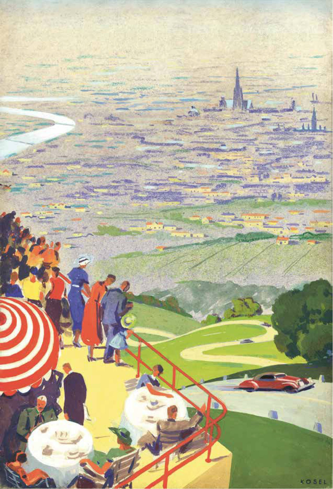
Car brochure: A view of Vienna from Höhenstrasse scenic road in 1936. Hermann Kosel, Wien Museum, no. 58201/5/2
Urban development during the Austrofascism period focused on job creation through projects such as the Höhenstrasse scenic road and the Reichsbrücke bridge, small-scale housing developments, churches and exclusively private urban regeneration projects. During this period, the RAVAG broadcasting centre and the small Freihausviertel area on Operngasse were developed, but other projects did not get off the ground, including the Führerschule at Fasangarten, the central train station and airport, and the Dollfuß monument. The architecture was dominated by classic modernism and acted as a rationalist counterpoint to the castle-like look of the superblocks built during the Red Vienna era.
Grand Paris An Unfulfilled Promise
Paris could already look back on a long history at the beginning of the twentieth century. France’s capital has been the subject of urban improvement projects since the Middle Ages. The major urban redevelopment programme managed by Prefect of the Seine Georges-Eugène Haussmann between 1853 and 1870 transformed Paris into a city committed to capitalism and modernity and made it a model for all of Europe. However, all of these plans focused on the area within the city walls. Comprehensive plans had not been made for Paris in the same way as those developed for cities like Vienna and Munich and their metropolitan areas at the end of the nineteenth century. Grand Paris only came onto the agenda at the beginning of the twentieth century. The various plans for the city region that have emerged since then testify to a rich and self-centred Paris alongside poorly equipped city suburbs. Paris intramuros developed differently from the surrounding metropolitan area, with the state playing a central role in the construction of new cities, transport routes and other large infrastructure projects. Although the Île-de-France region was finally created in 1976, its development has been characterised by a lack of ambition in the years since then. Since the turn of the millennium, the idea of a Grand Paris has been addressed in more detail in competitions and building programmes such as Le Grand Pari(s), the Grand Paris Express and Reinventing Paris, whereby competing urban concentration and development programmes urgently need to be coordinated.
Initial Ideas for Expanding an Enclosed Global City
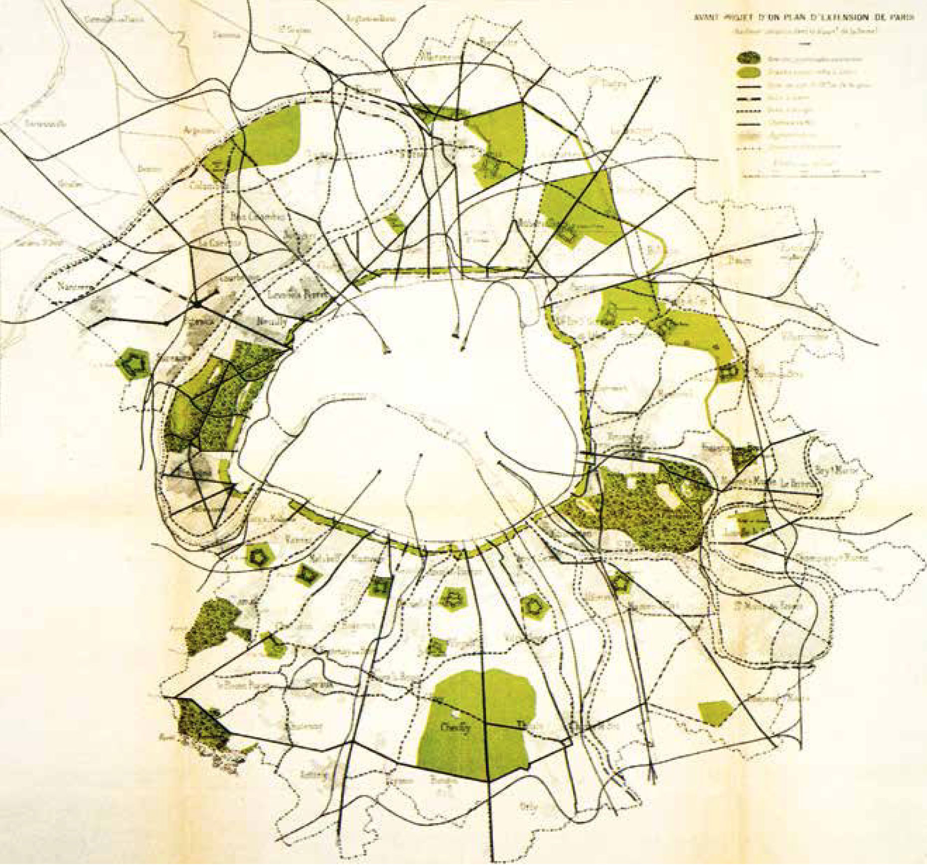
At the beginning of the twentieth century, Paris was still enclosed and separated from its suburbs by the fortifications built in 1840. The last administrative expansion took place in 1860 when Emperor Napoleon III decided to annex the suburbs within the fortifications. The first ideas for expanding the enclosed city came in the years after 1910 and were supported by the Musée social, the Association française des cités-jardins and the Société française des urbanistes. In 1911, the Seine department and the city of Paris set up an enlargement commission that published a report on the development of Paris and its suburbs. There was an initial focus on green issues. The options on the table included pocket parks, green belts and a system of parks based on the American model. An ideas competition for the regulation and expansion of Paris followed in 1919 and was modelled on the Greater Berlin Competition of 1910. The winner was Léon Jaussely, who had already won a competition for the expansion of Barcelona in 1904 and submitted a highly regarded entry to the Greater Berlin Competition together with Charles Nicod in 1909. Jaussely proposed a dual system of parks around Paris and also planned two industrial zones upstream and downstream of the Seine as well as urban expansions in the form of garden towns and suburbs. However, his proposal did not initially lead to any specific consequences.
First Ideas for Expansion Plans for Paris in the Period to 1919
A preliminary draft of an expansion plan for Paris designed by Louis Bonnier and Marcel Poëte in 1913. It shows the system of parks and park paths. Préfecture de la Seine, Commission d’extension de Paris, Considérations techniques préliminaires (La circulation, les espaces libres), (Paris, 1913), Planche 7
The Trente Glorieuses of 1946-1975: Big Plans, Mayor Infrastructure and Large Housing Developments
Large Housing Developments
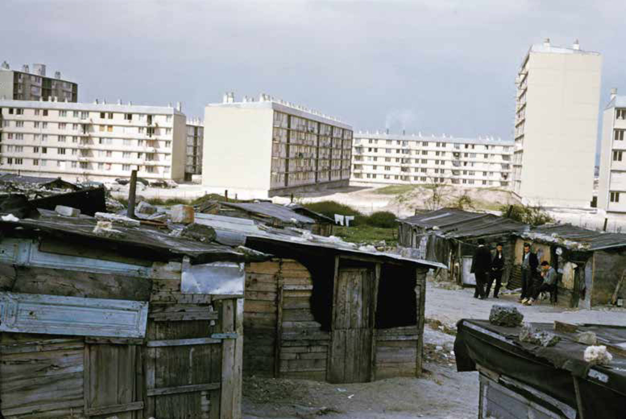
The Nanterre Algerian slum in around 1956 with the large Provinces Françaises housing development in the background. Institut Paris Region
The institutions and economy of the Paris region underwent a catching-up process during the ‘glorious thirty’ years (Trente Glorieuses) between 1946 and 1975. The District of the Paris Region administrative structure was created in 1961 and headed by Paul Delouvrier, a senior official appointed by President Charles de Gaulle. This was followed by the establishment of a regional planning office, the Institut d’Aménagement et d’Urbanisme (IAU), now the Institut Paris Region (IPR). A new regional development plan came into force in 1965. It broke with the radial-concentric urbanisation model and instead pushed metropolitan development along the valleys of the Seine and Marne rivers. The plan included the expansion of a regional rail system (RER) and the development of the new major Roissy Airport (also known as Paris Charles de Gaulle Airport). Five new satellite cities were to be built in order to accommodate expected population growth. This plan also paid little attention to the real Paris urban area. The construction of the Boulevard Périphérique ring road around Paris also strengthened the material border between Paris and its banlieue. However, the centre of Paris has undergone major changes with the removal of ‘unrenovated’ apartment blocks and the expansion of underground RER stations such as Les Halles and Étoile. It was possible to implement numerous inner-city urbanisme sur dalle projects in particular. This meant the complete separation of underground car traffic and above-ground pedestrian traffic, and was a particularly successful type of urbanisation in the car-oriented French city. A prominent example is the esplanade in the La Défense district, which has many of Paris’ high-rise buildings.
Greater London Urban Development between Regulation and Deregulation
Greater London has an eventful history stretching back more than 2,000 years and currently has a population of around 8.9 million people. The port city on the River Thames has been a key centre for trade and services for centuries. It is also an important international financial centre and an outstanding centre of culture, creativity, innovation and research. The city has been growing dynamically since the 1990s, and the population is expected to increase to 10.8 million by 2041 – even if current development is marked by uncertainty due to Brexit. London’s urban development over the past 100 years reflects political trends at national and local level. Following the Second World War, the welfare state was very active and implemented social housing projects on a large scale, shaping large parts of London in terms of urban development. Unprecedented deregulation policies were pushed during Margaret Thatcher’s term as prime minister (1979 – 1990), culminating in the abolition of the Greater London Council and a planning vacuum. The Greater London Authority was established in 1998 during the Tony Blair era (1997 – 2007). It was significantly smaller and more modern. London experienced a renaissance in urban development at the turn of the millennium, and the 2012 Summer Olympics brought global attention to the regenerated east of the city. In the years since then, London has strived to transform itself into a sustainable city, promoting cycling and trying to ensure affordable rents in the housing market.
Developing Visions for the Metropolitan Area of the Future
The last century of planning history has been characterised by a desire to develop the urban region based on a major plan designed to steer through a vision that encompasses the entire metropolitan area. These plans have always addressed current social and economic developments, such as the separation of residential and industrial areas (1943 County of London Plan) or the integration of disadvantaged sections of the population (London Plan). Finally, city-wide concepts such as those for strengthening London’s high streets dealt with the planning of the outer city – where areas with a lower population density, less mixed use or long distances to access public transport require special planning ideas.
The 1943 County of London Plan prepared by Patrick Abercrombie. It proposed to view the city as a collection of different types of areas, each with their own individual characteristics, such as important shopping streets, central or suburban areas, areas with vacant sites, and so on. Antiqua Print Gallery / Alamy Stock Photo, ID FDNFWD
Transforming East London
There is potential to develop a dense, extensive urban neighbourhood in the City East along the route of the Lea and Thames rivers from Enfield’s Meridian Water to Beckton. There are still many challenges in terms of infrastructure, particularly with regard to providing attractive and pedestrian-friendly public spaces. 5th Studio
The area of East London along the Thames River was characterised by port areas, industrial sites and working-class neighbourhoods for centuries. After the decline in these uses, transforming East London became a key urban development issue from the 1980s onwards. As with the Canary Wharf project, there were major initial setbacks due to the lack of transport links, high decontamination costs and insufficient demand. The development was given a real boost in 2005 when the city was awarded the contract to host the 2012 Summer Olympics. This decision triggered the large-scale project to build the Olympic Park in the Lower Lea Valley and paved the way for extensive projects to regenerate the surrounding neighbourhoods.