Pedro Pitarch Location: Madrid www.pedropitarch.com Pedro Pitarch, Gonzalo Rojas, Maria Escudero Landscape planning: Pedro Pitarch Other specialist planning: Rafael Zarza (Graphics)
Sub-area 1: ‘Neu Südkreuz’
As a major infrastructural hub, the Südkreuz railway station serves the region but also understands itself as a gateway to the world; the area is both local and global. The station district is currently dominated by transport routes that do not represent a ‘transit-oriented community’. The remaining areas and brownfield sites exhibit no prevailing structure. The development plan provides the railway station with multifunctional spaces, breathing new life into it. The freed-up urban space is spatially defined by structural additions, such as adjoining residential districts and experimental building types with potential for densification. The area around the station becomes a designed square. A place with this variety of functions requires several levels that also consider automated, individual transport systems (flying taxis, monorail systems, cable cars).
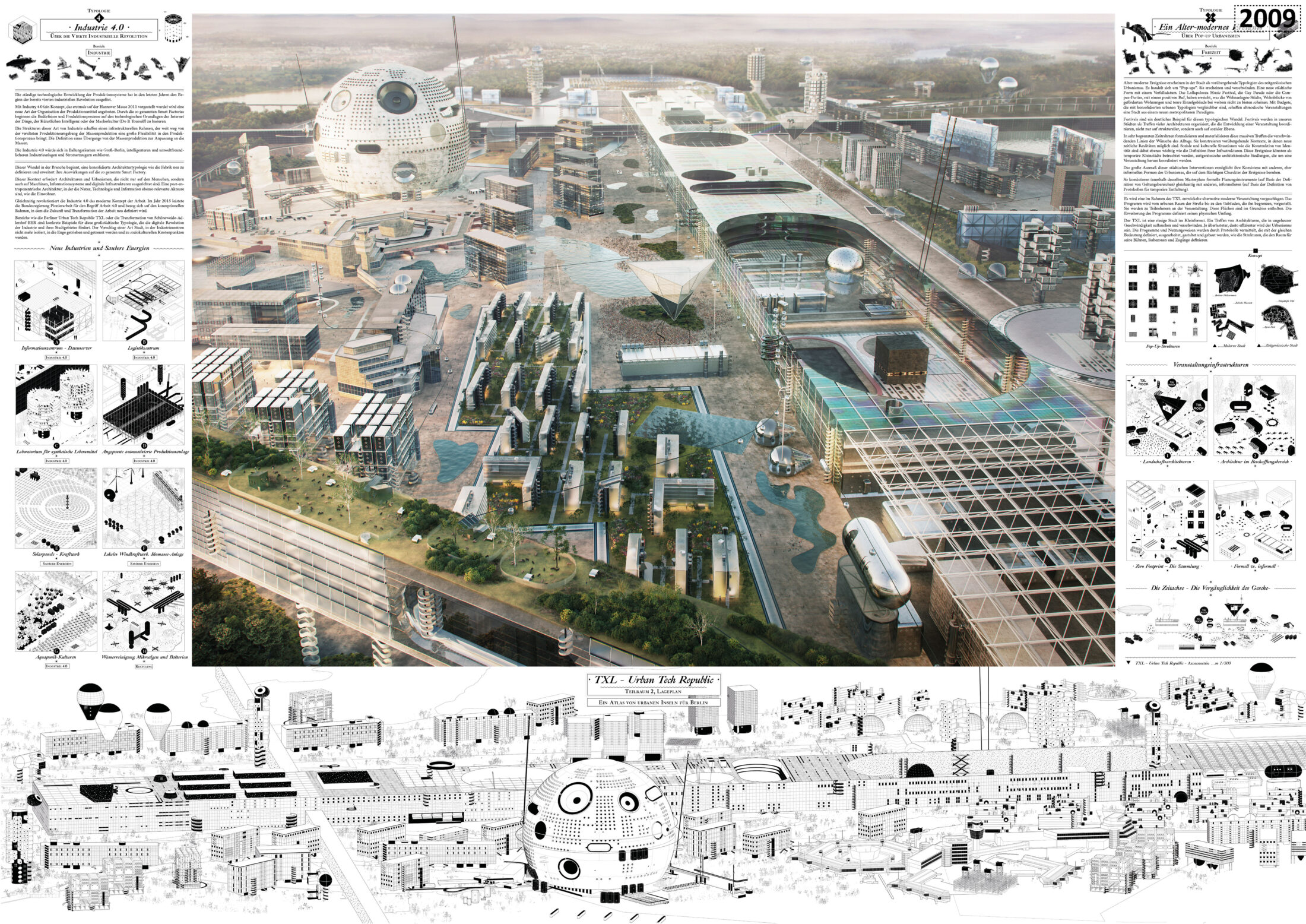
Sub-area 2: TXL – ‘Urban Tech Republic’
An airport’s exterior space is akin to an ‘island’ – a place that has not been opened up to all residents. Here, the area’s development is not based on traditional, but rather informal planning approaches, such as ‘protocols’ that define temporary projects. The design uses futuristic objects and unites them into spatial conglomerates that represent a new Industry 4.0 site. Nevertheless, the logistical order of the airport is maintained by the spatial structure of the runway as the site of production facilities. The three-dimensional image of the TXL site has not been developed as a fixed structural entity for the next 50 years. Rather, the plan represents ‘informal forms of urbanism based on the fleeting nature of events’. An experimental field for urban planning is to be created here.
Sub-area 3: ‘Königs Wusterhausen’ (KW)
The town has become popular as a residential and commuter town in recent years. Local public transport is good and well connected to the suburban and regional railways. The connections via the A10 motorway to Berlin and the A13 to Dresden and Cottbus favour private vehicles. The landscape offers excellent leisure activities with the lakes around Müggelsee in the north and the Heidesee landscape in the south. The urban area is divided into the districts around the palace, the railway station district, and the residential area between Cottbuser Stasse and Luckenwalder Strasse. Its proximity to the Berlin Brandenburg Airport gives it another an advantage that cannot be found elsewhere in the city. The design focuses on the densification of the prefabricated housing estate with an emphasis on ‘living and working’, the spatial connection between the three areas, and the creation of public spaces along with municipal facilities. The interventions use architectural measures to place the urban character in a relationship with public and private spaces. As it grows, Königs Wusterhausen will gain a distinctive identity.
Entrant‘s description
Archipelago Lab: An Atlas of Urban Islands for Berlin The contemporary city is no longer defined by plans. Planning has ceased to be an effective discipline in the production of urbanism and of cities. It has ceased to provide instruments and urban models that are adapted to the needs of societies undergoing constant change. The archipelago offers a new design, a new city model for the European metropolis. The archipelago identifies fragments of a city, the urban islands, which result from the often-strained relationship between a context and the surrounding urban mass. The islands are prototypes of the city in the city. They are defined by a series of latent but emerging urban conditions in our cities that have not yet been properly incorporated into the planning process. Every part, every setting, every island behaves like a laboratory. We are establishing a laboratory situation in the city as an archipelago. This project proposes a reinterpretation of urban planning that is based on the quantitative management of the urban area and on defining connections and relational networks between urban characteristics.
Six Typologies for a Contemporary Metropolitanism Six typologies are defined. Each of them corresponds to an existing metropolitan situation that forms a city and defines society; yet they are not designed within the professional practice of urbanism. Three specific examples are presented from the compendium of islands that make up the archipelago. Each one develops two urban typologies together, presenting a pair of opposing but coexisting situations. And so, there six situations, whose details not only allow us to explain the urban islands independently, but also to pursue a unified project that represents the narrative of the city of Berlin as an archipelago. The six situations are as follows. First, urban domestic life: the domestication of urbanism (housing). Second, an alternative-modern event: pop-up urbanisms (leisure). Third, convergence culture: the development of public life (culture and society). Fourth, Industry 4.0: the fourth industrial revolution (industry). Fifth, commuter urbanism: daily life with takeaway meals (infrastructure). And sixth, fluid work: overcoming boundaries between production and consumption (work).
Four Territorial Strategies Berlin’s urbanism is defined not only by its urban structure or its spatial form. It is defined by its composition as a ‘network’ and by the possibilities of connecting the urban actors scattered across the territory. The metropolitan soul of Berlin depends on its ability to create connections between different metropolitan elements and on how different contexts can be transformed into social catalysts and into networked city islands of a metropolitan archipelago.
1. Infrastructure and transport: from centres and peripheries to a network In contrast to a centralised and hierarchical model for transport infrastructure, here we propose using an open network model, both decentralised and democratic. Instead of emphasising the current model, which circles around the four main railway stations in Berlin, we propose a number of connection hubs. This constellation of small transport hubs is democratically distributed across the entire area and helps to adjust the large infrastructural inequalities between the inner-city and peripheral areas. Based on this model, the terms ‘centre’ and ‘periphery’ would become obsolete, because, as with a neural network, all points are equally accessible and perfectly interconnected. For this purpose, the existing hard infrastructures (trains and private cars) would be replaced with new models of smart mobilities, and soft infrastructures would be implemented.
2. Industry and Energy: From Concentration to Dispersion The industries of Berlin-Brandenburg are currently distributed unevenly. They are concentrated in large complexes far from conurbations, thus aggravating the tensions and inequalities between the city and suburbia. The distribution of the energy production centres is also unbalanced and creates a negative ecological footprint. For this competition, we propose a gradual transition to Industry 4.0 and renewable energies. This model dismantles the major hubs and distributes smaller ones throughout the entire region, in small industrial areas with integrated energy facilities. This new model has less impact on the land and on society, which allows it to be organically integrated into urban and natural areas. It rejects the already-outdated conventional model, which, because of its large and aggressive footprint, has prevented the coexistence of industry and society, energy and nature.
3. Nature: From Seclusion to Integration In our concept, nature is no longer a wilderness that is separate from urban settlements. Instead, it has multiplied into innumerable ‘natures’ that are no longer discovered but built, that are no longer found but are created. And, more importantly, they are not differentiated, sequential elements, but integrated into the urban elements and connected to them.
4. Living and Working (Settlement Areas): From Zone Formation to Hybridisation The strict zoning of urban programmes, which has shaped the design of the modern city for decades, has led to an inequality between large residential suburbs on the peripheries and dense work zones in the centres. This has resulted in a one-sided dependency between them, resulting in a lack of facilities in large metropolitan areas due to a lack of mixed programmes. Public and private areas are now trapped in separate areas. In view of this inequality, a hybridisation of private life and work is proposed. This is intended as a new urban and social paradigm in which new models of combining life and work can foster a balanced coexistence of both. A mixed territorial structure that integrates new urban tools such as teleworking, co-working, and co-living would create innovative forms of a more heterogeneous metropolitanism.
Three Specific Sub-areas:
1. TXL – Urban Tech Republic TXL is a metropolitan island that develops two of the six defined urban typologies: Industry 4.0 and alternative-modern industries that, unlike traditional industries, are based on research, information production, and customisation. The large scale of these urban interventions enables them to coexist with other, more informal forms of urbanism based on the fleeting nature of events. Thus, within the same master plan, formal planning tools coexist simultaneously with other, more informal ones.
3. Neu Südkreuz Particularly in cities like Berlin, the strong sense of community among citizens crosses the boundaries between micro and macro, between global and local. In many European cities, urban development is centred around infrastructural nodes based on so-called transit-oriented developments; in contrast, Greater Berlin expands on the concept of urban development, overlaying it with its pronounced social heterogeneity and thus generating transit-oriented communities. Neu Südkreuz is a good example of this and, therefore, a number of urban residential areas have been considered. Free from the traditional restrictions of the familiar living environment, a variety of programmes and uses penetrate into urban areas. The overall concept is supplemented by a catalogue of action protocols for the urban gaps so typical of Berlin which characterise the surrounding areas. The catalogue offers a set of strategies for sharing four kinds of empty space: abandoned land, inner courtyards, residual spaces, and decommissioned infrastructures.
Urban Island Königs Wusterhausen Instead of a conventional residential district, which, in most European cities, often becomes a commuter town, we are proposing a hybridisation of living and working, private and public, for this sub-area. The housing blocks do not become merely personal and private spaces, but are enlarged and expanded towards the city. Public capsules are incorporated, which offer social value by facilitating encounters, dialogues, production, and exchange. The master plan includes three superimposed levels of information: an island of urban fragments, scattered in a sea of nature and agriculture; housing blocks that contain public spaces; a matrix of work centres as well as cultural and urban facilities. The connection between the fragments is established by a series of pedestrian walkways and a system paths for electric vehicles (bicycles, gondolas, cable cars, and drones).
Thomas Stellmach Planning and Architecture / fabulism GbR Location: Berlin / Berlin www.tspa.eu www.fabulismoffice.com Team: TSPA: Filippo Imberti / Anke Parson / Alessandra Sammartino / Aurelija Matulevi ˇCiUtE / Isabell Enssle Landscape planning: Lysann Schmidt Landschaftsarchitektur Other specialist planning: Melissa Gómez (sustainable mobility and urban innovation advisor), Marcus Andreas (sustainability advisor), Florian Strenge (urbanism and design-process advisor)
Sub-area 1: ‘Intersection Oranienburg’
Existing residual areas, the open structural forms in the city centre, and the integrated landscape are suitable for further densification. The authors considered the three development scenarios – ‘safe society’, ‘global society’, and ‘neo-ecological society’ – and on that basis determined suitable locations that could also accommodate a wide range of cultural institutions and allow for ecological development. The focus of the plan is to integrate ecological corridors of an urban water management system. A new urban district with extensive recreational facilities is planned south of the suburban railway station. In the northern part of the city centre, commercial areas are densified, and an ‘organic park’ is created. Smaller projects, such as a river pool, a water hub for the generation of energy at the sluice facility, and a floating theatre in the Havel, as well as many other small interventions will enrich the water landscape and make Oranienburg more attractive. This will not only attract new residents, but also businesses, service companies, and production facilities that are appropriately incorporated into the city and the landscape.
Sub-area 2: ‘Intersection Trebbiner Water Landscape’
The district of Teltow-Fläming is an extraordinarily productive location for agricultural products in the metropolitan area. Large-scale farming inevitably causes environmental pollution. Production sites can be converted in an environmentally conscious manner into a regional park, which can become part of larger ecological corridors. The focus must be on the protection of the existing biosystems. The landscape and the waterways have to be returned to an unpolluted state to make it possible to organise food production in a controlled, small-scale manner. Water is a valuable commodity and requires constant maintenance. Water storage, infiltration, purification, and distribution are parts of a cycle that contributes to the self-sufficiency of the metropolitan area. Regional parks, such as in Trebbin, should continue to accommodate commercial and service locations as well as industrial production facilities, but they should stimulate the biological balance and not burden it.
Sub-area 3: ‘Kreuzberg Confetti’
Even neighbourhoods with a distinct identity, when they are densified and when their green areas are improved, can serve as models for other neighbourhoods to emulate. Here, the recultivation and renaturalisation of the former Luisenstadt Canal allow the existing green spaces to interact. Böckler Park, Waldeck Park, and Mariannenplatz are connected to the landscaped park near the canal by networks of green paths. The proposed architectural additions help define the streetscape and intensify the appearance of the blocks. The congested thoroughfares, such as Linden Strasse and Skalitzer Strasse, remain intact. Others, such as Heinrich-Heine-Strasse and Oranienstrasse, are improved with designated paths for pedestrians, bicycles, and cars. Nonetheless, traffic is eliminated from the inside of the blocks.
Entrant‘s description
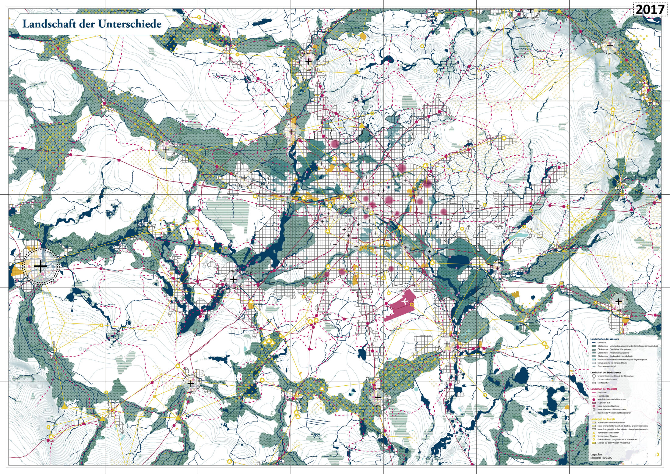
It is pointless to attempt to predict the political, cultural, or economic developments of the next 50 years. A quick look at the past makes that clear. However, there are challenges that we know will persist well beyond 2070. We know that the climate will change, and that, on average, Brandenburg will become warmer and drier. We know that this will have consequences for food production and biodiversity and that structures in the industrial, agricultural, and energy sectors will have to adapt to these new realities. Landscapes, water systems, and biosystems will also change. This transformation will last decades. It can build on the strengths of the Berlin-Brandenburg landscape. The lakes and rivers serve as the backbone of a cultural landscape that is characterised by heterogeneity and polycentricity. The ‘landscapes of differences’ concept suggests initiating a long-term transformation process of these systems to ensure a resilient and productive future for Brandenburg and Berlin. This transformation creates the framework in which the lives of citizens, including all their social and economic facets, can freely unfold and remain secure well into the future. Starting with the Brandenburg ecosystems, this transformation forms the basis for systemic and sustainable change. This transformation process is reflected in four landscapes.
1) Water Landscape The water landscape connects Brandenburg and Berlin: it shapes their industries, biodiversity, agriculture, energy, transport, and the character of their cultural landscapes, including their lakes and rivers. At the same time, the Elbe catchment area, where much of Brandenburg is located, has the second lowest water availability per capita in Europe. Climate change will make this worse. The reduction in rainfall and the increase in evaporation during the summer months will cause Brandenburg to become even drier; this dryness will be interrupted by increased bouts of heavy rain, which, in turn, will pollute the water and soil. We therefore understand the structure of Berlin-Brandenburg as a network of water cycles and place people’s daily interaction with water in the foreground. A system of green corridors in protected habitats for flora and fauna increases biodiversity. Waters and moorland are protected even more; monocultural, large-scale agricultural areas are to be converted into climate-proof farms. These are the elements of a cyclical economy for sustainable, respectful, and profitable use by the federal state.
2) Urban Landscape Berlin’s main traffic routes have defined the star-shaped settlement structure of Berlin, which has provided open spaces and prevented congestion by condensing traffic along the public transport axes. But the star-shaped settlement cannot handle the diverse nature of the Berlin-Brandenburg region alone. A more flexible and varied structure is needed, which is why the network of the water landscape will now infiltrate and support the star-shaped settlement of the nineteenth and twentieth centuries. Intersections arise, around which new centres will emerge and grow together to form networks. Berlin and Brandenburg, nature and city, join together to form a landscape of differences, composed of natural and man-made spaces. Urban sprawl is halted, and the existing settlement structure is densified and transformed at existing and new hubs in a targeted manner. These hubs are the centres of tomorrow. No longer the outskirts, they will be characterised by an exceptional quality of life and urban activity – in nature and near water.
3) Energy Landscape The supply of energy will also be decentralised. Energy will now be generated efficiently with wind, sun, and water. Solar panels and wind turbines are integrated into the landscape in a targeted manner in locations where wind speed, soil conditions, topography, and settlement structure are ideal. Industrial areas that are no longer functional are repurposed for the decentralised storage of energy in the form of hydrogen, water heat, or pumped storage. Short travel distances avoid energy losses; decentralisation increases resilience; surpluses are fed into the grid; oil and gas become obsolete; and carbon neutrality becomes the new norm. Power companies run by citizens and cooperative energy companies based on an intelligent network system make energy production accessible to all.
4) Mobility Landscape The average speed of motorised traffic in Berlin is currently 20 kilometres per hour. This is a speed people could easily maintain on (e-)bicycles. On average, households in Berlin own fewer cars than in other German cities. We are on the right path. The streets emptied by the coronavirus pandemic have given us an idea of what is possible with fewer vehicles: streets with room for playing and sports, and more peace and quiet. Yet, the technical development is unclear; and we do not know which solutions will prevail. What is certain, however, is that mobility will change, that cars and private transport will no longer play such a central role, and that autonomous driving will increase. We are therefore creating the conditions for more sustainable mobility. We propose the following: expand the network of bicycle lanes and make it suitable for fast e-mobility; create space for ‘inter-modality’ points, where travellers can switch between different modes of transport (communal, public, private); restrict motorised private transport; direct heavy traffic to transport axes and waterways and repurpose the freed-up areas as public spaces; and upgrade streets as shared spaces for various future modes of mobility. We have selected three sub-areas to illustrate our concepts.
1) Intersection Oranienburg Oranienburg typifies the complexity of the region. It is characterised by different urban structures, active and decommissioned industrial plants, and a diverse, water-permeated landscape. A centre of tomorrow emerges at the intersection of the star-shaped settlement structure and the landscape network. Ecosystems are strengthened, and sustainable urban structures emerge. The city coalesces around the scenic network along Lehnitz Lake, the Havel River, and the Havel Canal. Precipitation is collected, recycled, buffered, infiltrated, and removed during heavy rains by a sustainable water management system. This way, the city is cooled in hot summers, and soil nutrients are preserved. The ‘inter-modal transport’ concept relies on a combination of regional public transport connections with frequent service and a dense network of (e-)bicycle routes. A park with a community garden is created on Sachsenhausener Strasse, combining urban agriculture, sustainable production, and urban and residential housing. At the southern end of Lehnitz Lake, a former industrial site is renovated and the floors are organically cleaned. Part of the area will be converted into an urban park with leisure facilities; another part will be developed into a mixed residential area between the park and the water. An energy park is created in the northern green area close to Kuhbrücke. The energy generated here is converted into hydrogen and stored. A research centre for water management is built east of the Lehnitz sluice.
2) Trebbin Water Landscape The district of Teltow-Fläming is typified by rivers and artificial canals, agriculture, shrinking villages, polluted waters, monocultural forests, and a loss of biodiversity. It is also the most productive agricultural district in the Brandenburg region and is thus also responsible for causing environmental pollution. We present how the spatial and functional systems of the area can be sustainably transformed into systems of the cyclical economy. The regional park is part of the larger ecological corridors. It protects and uses the landscape, biosystems, and waters productively for energy, leisure, and food production, resulting in a new cultural landscape that is not bucolic, but efficient and productive. Small-scale organic farming replaces monocultures. A system of water storage, infiltration, purification, and recycling enables high drinking water quality standards and ensures the supply of water across all seasons. A green energy system produces wind and solar energy and networks production sites with decentralised energy storage systems. Cooperative energy companies for inexpensive and decentralised energy management are founded.
3) Kreuzberg Confetti Berlin’s heterogeneous architectural history is still visible in northern Luisenstadt and southern Friedrichstadt. Our concept elevates the mixed environment in Kreuzberg into a ‘super-mix’ environment, demonstrating that urban density and living in nature are compatible with each other. It prepares the mobility infrastructure for the ongoing shift towards sustainable transport methods and creates an urban landscape that protects both water and environment. We restrict through traffic to axes such as Skalitzer Strasse and Linden Strasse, and we redesign streets such as Heinrich-Heine-Strasse and Oranienstrasse as shared spaces. This creates car-free super blocks, with attractive footpaths and (e-)bicycle lanes. The freed-up areas are converted into green spaces. Mobility becomes multi-modal; switching between different modes of transport becomes easy; and different kinds of shared mobility flourish. Lenné’s Luisenstadt Canal is opened up again and expanded. Mariannenplatz, Waldeck Park, and Böckler Park are expanded to form a park system. Precipitation is managed intelligently and is used to cool the city. Flooding events are mitigated by decentralised infiltration in park areas, hollows, tree trenches, and retention areas. The attractive green spaces invite residents and visitors alike to engage in sports and other recreational activities. The air quality is excellent. The buildings are densified, expanded, repurposed, and on the ground floor revitalised – all in a targeted manner, without additional soil sealing. Linear blocks from the 1970s, buildings from the Gründerzeit years, and buildings from the International Building Exhibition are placed in a new context without losing their original character. A wider range of functions are mixed together; and the paths become even shorter.
Jordi & Keller Architekten / Pellnitz Architektur und Städtebau Location: Berlin www.jordi-keller.de www.pellnitz.de Team: M. Eng. Yannick Langer, Dipl.-Ing. Nandor Kovac, Frederic Jordi Landscape planning: Christina Kautz Landschaftsarchitektur Other specialist planning: Ludwig Krause (traffic and urban planner)
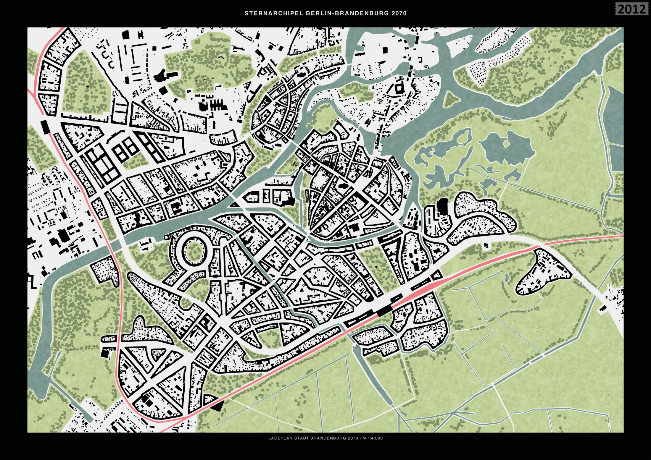
Sub-area 1: ‘Brandenburg an der Havel’
With the planned construction of the third and fourth railway rings in the metropolitan area, it is conceivable that Brandenburg an der Havel can be densified to accommodate twice its current population. The aim of the urban development plan is to promote closer interconnection between city and nature while considering historical identities. The existing buildings between Neustadt and the railway station are structurally upgraded by closing the blocks. The structures within the blocks are largely preserved. Potential development areas are located southwest of the station and in the west of the old town up to the railway line. In addition, south of the station, along the Jakobsgraben canal, the existing buildings, which have a more open composition, are densified with street-fronting buildings. When viewed from above, the expanded block structure harmonises the urban structure.
Sub-area 2: ‘Westkreuz’
Currently, when various transport systems going in different directions intersect, traffic jams and structural overloads occur, especially at peak times. The AVUS (Automobile Traffic and Practice Road) was the world’s first road created specifically for automobiles and was once an important car-racing circuit. It is redesigned as a boulevard in this concept. The car traffic is redirected underground, and the rail traffic is above ground. The track systems are converted into a green space that connects the nearby Lietzensee Park with Grunewald. The north curve houses a new football stadium, and the urban planning additions adhere to the Charlottenburg block structure. The dominant element is a gate-like situation formed by two highrise buildings with a height of up to 200 metres. A similar ensemble is also to be built at the three other train stations.
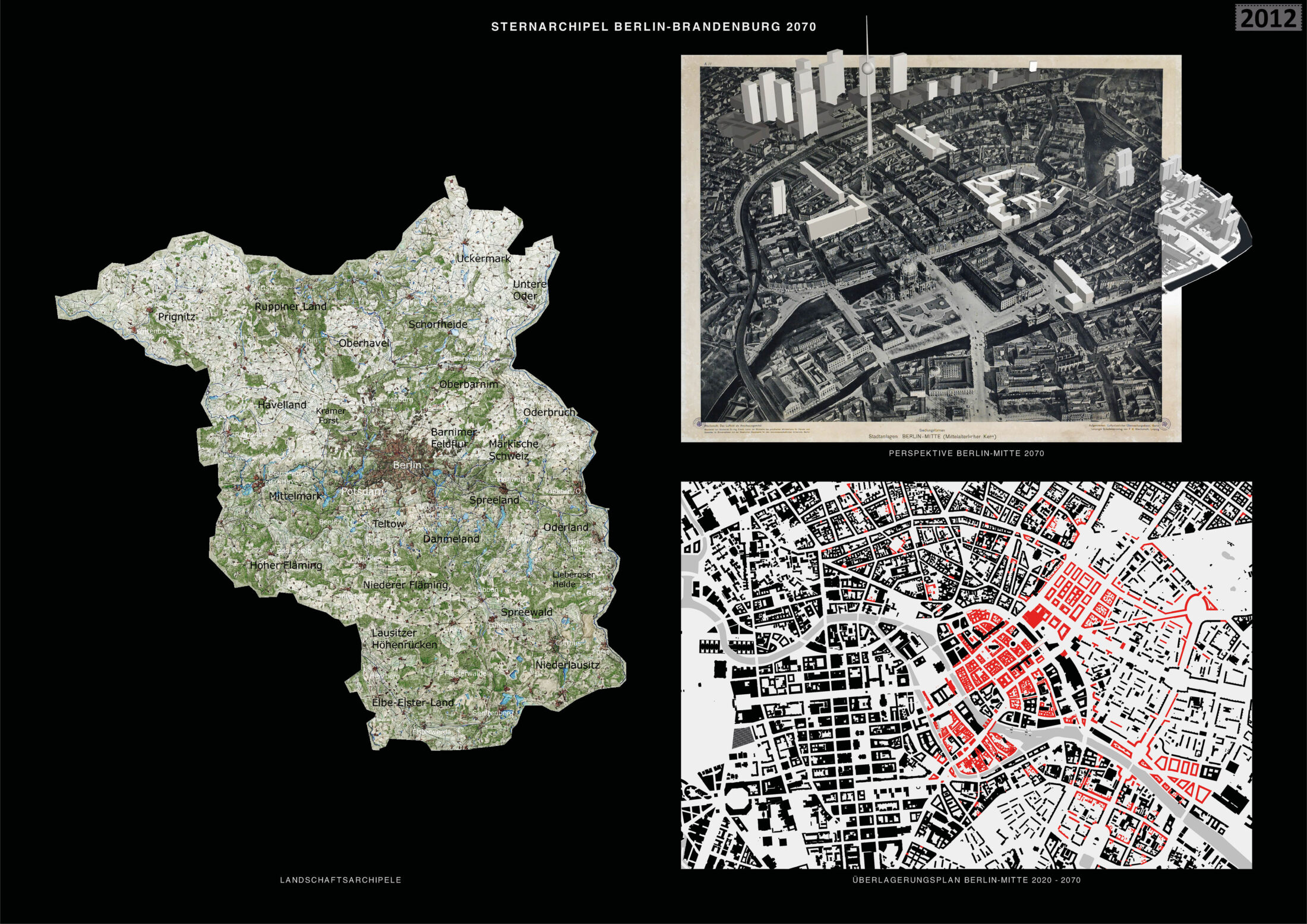
Sub-area 3: ‘Berlin-Mitte’
Only a few entries focused on Berlin-Mitte. The centre is roughly based on the historic centre of 1920. Parts of the neighbouring royal city are also enhanced based on the city plan from 1920. The Stralau Vorstadt (Stralau Suburb) is densified along the street with large residential buildings. The concept supports the idea of strengthening the historic centre with historicist architecture and additional cultural facilities. The existing housing will enter into a ‘coalition’ with the reconstructed city plan. Peter Joseph Lenné’s idea of integrating ‘jewelled water axes’ into the city is revisited. The concept proposes extending the waterway from the Engelbecken in Kreuzberg to Volkspark Friedrichshain via Strausberger Platz. The waterway is to be designed on both sides as a green space with avenues and recreational spaces.
Entrant‘s description
Star-shaped Archipelago Berlin-Brandenburg 2070 – Urban Development Concept Berlin-Brandenburg was formed out of various villages and towns. This development has led to an archipelago of centres, within and beyond Berlin, that are connected by radial axes and circular railway rings. The structure within Berlin’s inner railway ring is characterised by green islands in the dense, urban sea of houses; beyond the ring, it is characterised by settlement islands separated by green and natural spaces. Between the radials of the star-shaped structure of Berlin, the large landscape areas protrude far into the centre of the metropolitan region. The star-shaped archipelago, with its dialectic between nature and development, represents the greatest qualities and potentials of the Berlin-Brandenburg metropolitan region. These need to be strengthened and further developed. New building sites and residential areas should be created largely within this structure based on the conversion, consolidation, and modification of existing settlement areas. The current star-shaped structure of the Berlin-Brandenburg metropolitan region is to be expanded and differentiated with the star-shaped archipelago model proposed here. The concept of the star-shaped settlement – especially in conjunction with its visual representation in the Berlin-Brandenburg regional development plan – evokes a sense of unlimited densification within the star-shaped settlement structure. As such, it does not consider the infiltration of urbanised areas into the surrounding nature. The concept of the star-shaped archipelago, which is based on the concept of Berlin as a ‘green archipelago’ and on ideas from the Greater Berlin Competition of 1910, is to pursue this dialectical interpenetration of city and nature as a new model.
Decentralisation Goal The federal government’s decentralisation goal sets out to create equal living conditions throughout the region, with a special focus on structurally weaker rural areas. Accordingly, this urban development concept assumes that Brandenburg’s existing towns and cities will be strengthened over the long term, in part to relieve the pressure on Berlin. The measures proposed here can accommodate up to twice the number of inhabitants in the metropolitan region without compromising the quality of outdoor spaces and with only a minimal amount of additional soil sealing.
Railway Rings Berlin currently has an inner railway ring and an outer railway ring. Two additional railway rings will be created. These will link the existing centres along the radial railway lines, strengthening them and helping to reduce transit traffic through Berlin. The third ring will largely run on existing railway tracks or directly along the Berlin circular motorway or ring road and will connect towns such as Oranienburg, Bernau, Straußberg, Königs Wusterhausen, Beelitz, and Nauen. The fourth ring will connect the so-called ‘second-tier ’cities, including Brandenburg an der Havel, Frankfurt an der Oder, and Cottbus. Both rings could link new sites that emerge for industries and businesses (such as Tesla) with the next locations on the respective ring. As a result, these sites will remain close to the new settlements and to Berlin.
Sub-area Brandenburg an der Havel The strengthening of second-tier cities such as Brandenburg an der Havel, Frankfurt an der Oder, and Cottbus is a focus of the strategic development concept. The great qualities of these cities – their unity with the landscape, their historic city centres, and their good connections to Berlin – make them ideal as regional centres. When expanding these cities, it is important to preserve their historical character and their close connection to nature. The city of Brandenburg an der Havel is a good example of a second-tier city. The existing structures and the natural and organic elements of the city are integrated and further developed. The existing buildings with their block structures are further densified and extended to the city’s edge, marking a clear transition to the surrounding landscape. The contrast between the organic forms of the city, which can be found in the historic centre, and the typical elements of industrial development such as tall silos, is explored in the form of new landmarks. At the same time, the natural spaces also enter into the city, so that the city and nature reconnect in a variety of ways.
Sub-area Westkreuz The basic ideas of the master plan are exemplified by the development plan for the Westkreuz area: densification within the settlement boundaries, the development and conversion of traffic areas and unused areas, and the strengthening of the intersections of the railway rings and railway radials. The Westkreuz suburban railway station will be expanded to become a regional railway station which, like the Gesundbrunnen station, will allow riders to transfer from regional trains from the surrounding areas to the suburban ring railway. The motorway will now run underground and be partially dismantled. This will eliminate its destructive ‘barrier effect’. A dense, socially and functionally mixed urban district is planned on the large site and will be networked with the surrounding quarters. At Westkreuz, and at the three other railway intersections (Südkreuz, Ostkreuz, and Nordkreuz), two high-rise buildings with a height of between 100 and 200 metres will be built as a gateway to central Berlin. These pairs of high-rise buildings frame the high-rise groups in the central locations in the city centre. Most of the old railway tracks will be converted into a park, which will connect Grunewald to the east-west axis via the Lietzensee Park. The east-west axis will be developed into a green boulevard with rows of trees and a bicycle expressway in the middle.
Sub-area Berlin-Mitte A discussion of the Berlin-Brandenburg metropolitan region cannot overlook its centre, the historic heart of Berlin. Although the strategic development in the present concept primarily focuses on strengthening towns on the rings, central Berlin plays a vital role for the entire region. The historical development of Berlin from a small settlement into the political centre of Germany can only be observed here. The cultural institutions in the city centre also radiate across the entire metropolitan region. For the medieval core, it is proposed that the existing buildings from the GDR era are brought into a dialogue with a critical reconstruction of the historic city plan, so that Berlin’s long history is once again legible and the individual histories of the buildings can be remembered through their historical addresses. To the east of Berlin’s medieval centre, Lenné’s ‘green corridor’ project is revisited, and the connection between the Engelbecken and Volkspark Friedrichshain (via Straussberger Platz) is converted into a continuous green corridor and monumentalised by large urban squares.
Strategic Reflections on the Process As yet, there is no common, trans-national public discourse on the strategic development of the Berlin-Brandenburg metropolitan region. With its plans and images, the Berlin-Brandenburg 2070 competition offers an outstanding opportunity to initiate and advance this discussion. The winners of the competition should develop a common and comprehensive concept for the area’s long-term development through a multi-year process involving a dialogue with the public. This should be conducted in cooperation with the joint state planning authorities and in exchange with the citizens of the two states.
KOPPERROTH / SMAQ / Alex Wall Location: Berlin / Berlin / Cambridge (USA) www.kopperroth.de / www.smaq.net / www.alexwall.com Team: Evelina Faliagka, Moritz Maria Karl, Dominik Renner Landscape architecture: Dipl.-Ing. Stefan Tischer, freelance landscape architect Other specialist planning: Office MMK – Urban Technologies
Sub-area 1:
At the edges of the settlement radials, areas are divided into small parcels to promote a mix of uses. This not only stimulate agriculture, but spatially defines the populated areas. The parcels structure a dense network of paths and create parklike landscapes. Existing settlements are supplemented, and new development areas for housing, recreational activities, and energy facilities are set in a spatially defined environment. This in-between landscape can be used as an experimental space for organic farming, decentralised energy supply, and alternative settlement areas, which simultaneously counteracts urban sprawl. Special places are marked and represented in the form of zeros, or circles. As a result, individual uses such as small settlements, agricultural businesses, and energy systems can be placed in the landscape.
Sub-area 2:
Inspired by the spatial arrangement of allotment gardens, ‘parcels’ measuring 150 x 150 metres are defined. Each of these clusters can be divided and expanded to accommodate different uses. The supply of energy and water is decentralised and is managed through collective self-government. 50 per cent of each parcel must be cultivated agriculturally to maintain the character of a park landscape. The parcels are enclosed by hollows and depressions, which ensure the retention and infiltration of surface water along the path system. The planting of trees and hedges creates natural corridors that improve the microclimate. The outlined grid depicts the network of public paths. The parcels are awarded in the form of heritable leaseholds based on concept-based applications. This land-use concept promotes social and ecological forms of living with the aim of establishing a ‘transition society’ for more open and flexible lifestyles.
Sub-area 3:
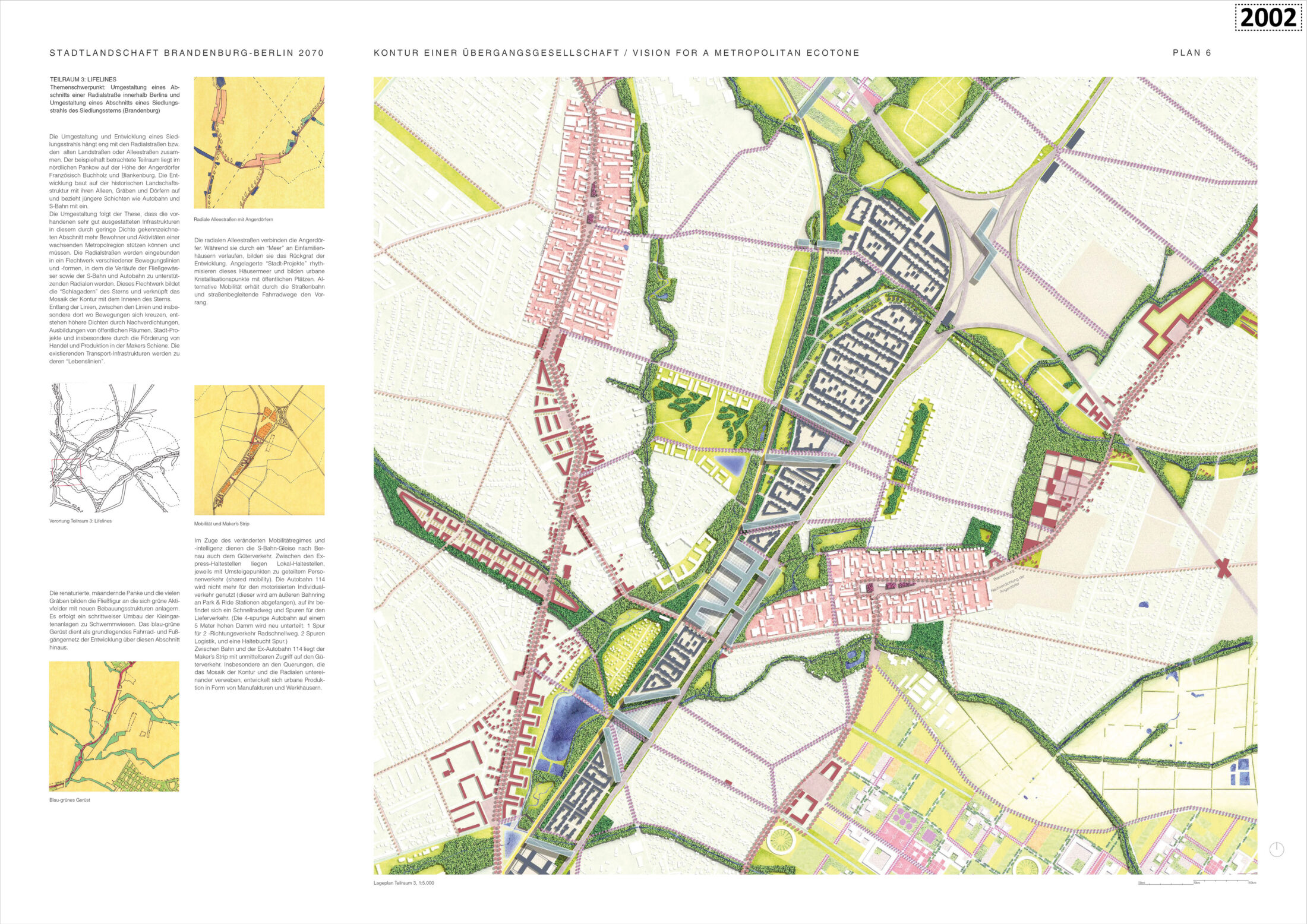
There are allotment gardens with low structural density along main access roads such as the A114 and the suburban railway line between Französisches Buchholz and Blankenfelde (including the Blankenfelde railway station and a new possible railway station on Bucherstrasse). These areas are suitable for new developments, particularly since technical infrastructure and public transport are already available. Here, the concept is centred on orderly densification along the radials. Existing landscape elements such as avenues, alluvial meadows, and the Panke River are renaturalised. The desired mixed-use environment, which includes housing, office spaces, manufacturing, and logistics centres, generates a variety of building typologies that allow high structural density. In the areas that transition to the historic green villages, the design places housing estates with single-family homes and integrates a small part of the allotment garden settlements into the landscape area.
Entrant‘s description
Berlin is growing, and with it, the surrounding areas in Brandenburg. Over the past century, Brandenburg and Berlin have become increasingly interconnected due to developments along the transport axes that make up the rays of the star-shaped settlement structure. It makes sense to further develop the Berlin-Brandenburg metropolitan region along existing infrastructural lines and arteries and to consolidate the star-shaped settlement structure. However, a new perspective and a future-oriented economic and social vision are needed. To this end, we must strengthen the Brandenburg regions surrounding Berlin in response to the dynamic expansion of Berlin’s centre. The development model for the metropolitan region should be based on three initiatives. First, we need to regenerate the landscape as an ecological environment, social milieu, and economic force. Second, we need to create an interface between the city and countryside. This interface must be marked by a legible outline within the star-shaped settlement structure; and it must serve as an ‘ecotone’, ‘edge habitat’, or ‘transition area’. Third, we need to interconnect the radial axes with green areas and water and link the settlement rays with orbital streets surrounding them, thus developing the star into a network.
Our strategy of gradually converting Berlin-Brandenburg into an urbanised-landscaped region is based on expanding and activating existing landscapes and infrastructural structures and reanimating latent existing ones. The strategy also involves introducing new innovative uses and leaving enough flexible spaces for unforeseen uses. A sustainable metropolis can only be developed on the basis of the landscape or countryside as a starting point. For Berlin and Brandenburg, the typical landscape structures include waterways, tree-lined avenues, ‘Angerdöfer’ (villages built around a central village green), and fields. The various terrains, soils, water structures, local climates, and habitats are the basis for both the diversification of landscape structures and structural development strategies. The Schmettau map series includes historical ordnance survey maps of the area and offers valuable clues for activating the landscape. Densification measures should occur along the existing, often well-equipped infrastructures, particularly the arteries along railway and tram lines. The existing access network composed of historic tree-lined avenues is well suited to accommodate new forms of micromobility (on-demand buses, shared mobility, e-bikes). This creates a close-knit development network between less densely populated areas. Motorway feeder roads lying within the outer ring road become expressways and serve to transport goods, thus supporting inner-city production sites and factories. Travellers heading towards the city centre with private modes of transport from the surrounding areas and outskirts can transfer to the suburban train on the outer ring. A socially just and open society requires spatial and economic freedom in which diverse lifestyles and integration models can be tested and practised. Concept-based land-allocation procedures, designed to prevent the appreciation of real estate value, serve to promote cooperative, non-profit housing and make development projects accessible to smaller players. We illustrate our strategy of gradually converting the capital region into a landscaped-urbanised area with proposals for three specific locations. There are three main areas of focus: regional parks, new housing construction, and the transformation of the rays of the star-shaped settlement structure. Here, we specifically explore the settlements along the ray composed of Pankow, Buch, Bernau, and Barnim. A socially just and open society requires spatial and economic freedom in which diverse lifestyles and integration models can be tested and practised. Concept-based land-allocation procedures, designed to prevent the appreciation of real estate value, serve to promote cooperative, non-profit housing and make development projects accessible to smaller players. We illustrate our strategy of gradually converting the capital region into a landscaped-urbanised area with proposals for three specific locations. There are three main areas of focus: regional parks, new housing construction, and the transformation of the rays of the star-shaped settlement structure. Here, we specifically explore the settlements along the ray composed of Pankow, Buch, Bernau, and Barnim.
Mosaic of Contextual and Inherent Diversity The contour is formed by the contextual arrangement of five urban and rural elements that form a spatial mosaic: nature reserves; forest clearings; housing and regenerative microfarming; new urban areas; and special-use structures, large-scale projects, and energy infrastructure. These building blocks contribute to the densification of the star-shaped settlement structure and also strengthen the rural areas of Brandenburg, in part by reintroducing nature. Depending on the location, the mosaic can promote urban development or be a site of innovative agriculture and exemplary natural strategies. This is the strength of the contour: each building block consists of a variety of lifestyles, forest ecosystems, and biotopes.
Barnim Regional Park (Bernau-Werneuchten) In addition to the existing nature parks, four special park landscapes – regional parks – are to be established, two of which are already well developed. The new regional park between Bernau and Werneuchen will function as an incubator, stimulating the landscape transformation process. The Schmettau map series provides a point of reference for the reconstruction and development measures, as the microtopography and soil conditions have remained largely unchanged. These natural areas are to be expanded exponentially in relation to the current state (approximately by a factor of ten). In addition, existing forests are to be gradually returned to their original condition or repurposed for land-use management or – as natural parks and nature preserves – integrated into the surroundings.
Contour Mosaic, Focus: New Housing in the Relevant ‘Mosaic Stone’ The contour consists of five different urban and rural building blocks and creates an ecologically, economically, and socially diverse living environment by offering a mix of new housing developments and introducing new flora. The example used here is the area between Buch and Schwanebeck, which is crossed by the A10 motorway.
New Residential Construction This mosaic stone establishes an experimental field that promotes ecological and social living spaces as well as diversity. As an ‘edge habitat’, it can accommodate various lifestyles within a parcel and promotes a decentralised, collective method of supplying energy and water. The structure and scale of the settlement is based on the dimensions that are required for agricultural self-sufficiency. The average parcel measures around 150 × 150 metres, which can be expanded or subdivided according to location and use. Existing landscape and building structures are either integrated or delineate the structure. Each parcel is surrounded by a public network of roads that can be flexibly assigned to different types of traffic. Mixed-use constellations are to be ensured by an application process in which the applicant’s socio-ecological innovation concept is stated. The ensuing diversity in lifestyles will enable new qualities: economic construction methods; mutual care; carpooling; diverse public spaces; and innovations in agricultural-ecological undertakings. The parcels are leased and not sold.
Lifelines, focus: redesigning a section of a radial street within Berlin; redesigning a section of an arm of the star-shaped settlement (Brandenburg). The sub-area considered as an example lies in northern Pankow near Französisches Buchholz and Blankenburg. The development builds on the historical landscape structure with its tree-lined avenues, ditches, and villages and includes more recent additions, such as the motorway and the suburban railway. The redesign is based on the principle that existing and developed infrastructures in this area, which is characterised by low density, can and should support more residents and activities in a growing metropolitan region. The radial roads are integrated into a network of various arteries and forms in which the waterways, motorway, and suburban railway become supporting radials. This network constitutes the arteries of the star-shaped settlement structure and links the contour’s mosaics with the star’s interior. Along the arteries, between the arteries, and especially where transport routes intersect, higher densities are created through densification, the formation of public spaces, city projects, and the promotion of local and regional trade and production. The existing transport infrastructures become their ‘lifelines’.
Bernd Albers / Silvia Malcovati / Günther Vogt Location: Berlin / Potsdam / Zurich www.berndalbers.com /www.silviamalcovati.com / www.vogt-la.com/ www.arup.com/offices/germany/berlin Team: M. A. Dan Dahari (project leader), B.A. Iveel Bold, Dipl.-Ing. Maren Brakebusch, Bess Laaring, Dr. Gereon Uerz,Dipl.-Ing. M. Arch Rudi Scheuermann, Ibrahem Alsalamh Landscape architecture: VOGT LANDSCHAFT GMBH Other specialist planning: Arup Deutschland GmbH
Sub-area 1: Tempelhof – Südkreuz
The area between Südkreuz and Tempelhofer Feld along the suburban railway line currently consists of abandoned commercial sites, railway facilities, allotment gardens, peripheral areas near the former Templehof Airport, and remaining areas surrounding the Südkreuz railway station. The A10 metropolitan motorway and the suburban railway ring dominate the urban situation. The design demonstrates how one can further develop these districts based on the existing nineteenth-century urban structure and clearly distinguishes it from the garden city of Neu-Tempelhof (also known as ‘Fliegersiedlung’ – ‘Aviation Settlement’). The buildings along the railway ring function as distinct urban borders. For the Aviation Settlement, the development proposal adheres to the proportions of the existing residential buildings in the sub-areas. The development along the railway line mixes housing, workplaces, and essential amenities. The additional buildings south of the airport building, like the building itself, accommodate cultural and research institutions. A group of three high-rise buildings marks the centre and forms a gateway to the south.
Sub-area 2: Bernau
There is great potential for urban development to the northwest and southeast of the Bernau railway station. Two conversion areas along the railway line, which penetrate into the surrounding landscape to the southwest, consist of settlements with transport infrastructure that are intended to initiate a new phase of mixed-use urban development. The proximity of the A10 and A11 junction and of inexpensive local, regional, and long-distance rail connections support the idea of urban expansion at this location. The concept foresees high densification here, in contrast to the existing districts. In the area surrounding the railway station, block structures have been developed that enclose the railway line and open to the north and south. To the northeast, the conversion area is lined with a series of U-shaped buildings that form a large-scale addition to Panke Park. The auxiliary functions in the southwest area are intended to support tourism and accommodate a wider range of recreational activities.
Sub-area 3: Schwedt an der Oder
The former royal seat of Schwedt an der Oder, which was badly destroyed in the Second World War, lies on the northeastern edge of the regional development plan. The town of Schwedt would benefit greatly from a rail connection along the existing Berlin–Stettin line. The design concept envisages establishing this connection and incorporating the central station area of Schwedt into a new urban mixed-use location. Gaps and remaining areas in the urban structure are filled, and new constellations are developed – based on the concept of critical reconstruction – to revive the historical city layout. A unique selling point is the landscape of the lower Oder Valley with its nature reserves and national park. Uniting the urban development more closely with the river landscape would not only strengthen the area around the Uckermark areal with the former royal palace but would also signify an upgrade for the entire city.
Entrant‘s description
Growing Together: The Landscape City Berlin and Brandenburg Will Grow Together
A future concept for the Berlin-Brandenburg metropolitan region not only requires cooperative political processes but must also include a master plan for the city and the surrounding countryside. This plan is based on historical considerations and on the existing potential and characteristics of the Berlin-Brandenburg urban and natural landscape.
Towns in Berlin and Brandenburg will expand inwards. Berlin has great potential for internal growth, densification, and spatial optimisation. This potential can be realised through the use of vacant lots and brownfield sites and through the transformation of existing infrastructures. Berlin’s green character must also be preserved, as it embodies a matchless legacy of urban planning and will be increasingly important for the area’s climatic balance in the future. Towns in Brandenburg also have much capacity for growth within their borders. This inner growth can preserve and bolster the particular characteristics of the state’s more urban areas. Railways will ensure future mobility and transport. Against the backdrop of climate change and the energy transition, the expansion of the road and motorway network is not a satisfactory solution for the future. In contrast, railway transport allows for a more sustainable future driven by the digital revolution. The future growth of the city will take place near new railway lines.
Berlin-Brandenburg and Europe The global shift towards sustainable modes of transport and the expansion of railway and water transport are turning the Berlin-Brandenburg region into a hub of diverse cultural and trade corridors in the German and European context. Accordingly, this railway and waterway network is undergoing continuous optimisation. Growth takes place along the radial axes and connects the towns and city. The urban expansion areas follow the star-shaped railway lines between the protected natural landscape and cultural landscapes, thereby transforming the scattered settlement areas into more compact urban structures. In this way, buildable land for one million new residents is gained without radically altering the character of the urban structure or disturbing the harmonious natural areas.
The Countryside Comes to the Towns The Berlin countryside is characterised by forests, lakes, and agricultural areas and harbours unique potential for the climatic and ecological regeneration of the region in the future. Strengthening the spatial connection between these areas and improving their incorporation into the growing and increasingly populous urban region is central to our concept. Natural and cultural landscapes will be boosted with the appropriate infrastructure and networks of paths for outdoor activities. Cultural landscapes reinforce the perception and appreciation of the region as an integrated entity and intensify the population’s connection with it, promoting empathy between the rural and urban residents.
The radial settlement arteries complement one another along the railway lines with their adjacent cultural landscapes. They reinforce Berlin’s star-shaped settlement structure and result in a coherent structure with complementary qualities: city, cultural landscape, and agricultural land. The third ring connects the radial arteries. We are adding a new third ring to the first and second rings to accelerate the connection routes between the towns on the outskirts of Berlin, thereby avoiding detours through Berlin. Because of the density and proximity of many towns in the north, east, and south, the third ring will also link these places; and the third ring will join the second ring to the west of Potsdam. This bypass optimises the internal dynamics of the second and third rings. The area inside Berlin’s first railway ring becomes the geometric centre of Berlin’s series of concentric transport rings. The third ring significantly increases mobility in the areas surrounding Berlin and reduces their dependence on the city. This ring will be realised in phases. The first segment will be built in the northeast, since the greatest added value is expected there, in coordination with the growth of Brandenburg’s centres. One can ensure the desired network optimisation, even when building the third ring in stages, by connecting it to the radial transport axes. Urban centres, composed of housing, commercial spaces, and social infrastructures, which will in turn benefit from optimal transport infrastructure, will emerge near the intersections of the rings and radial axes. Thus, Brandenburg’s growth areas near the third ring will see more opportunities to develop and connect with one other independently of Berlin.
The Third Ring as an Elevated Railway The third ring is conceived as an elevated railway in order to protect the cultural landscape, agriculture, and wildlife. This also simplifies intersections between roads, motorways, and rivers. Lightweight construction fosters a harmonious relationship with nature and agriculture. The elevated trains provide a pleasing view of the surrounding countryside, and the suburban train stations in the towns become attractive centres. We have selected three locations to illustrate the master plan. We analyse each location in terms of mobility, history, growth, and landscape. Two of the locations (Tempelhof-Südkreuz and Bernau) are situated at the intersection of radials and rings; the third location (Schwedt) is situated along a radial. Using these locations as examples, we demonstrate the characteristic features of the Berlin-Brandenburg region. These include: urban areas with contradicting histories; industries; diverse natural areas; good railway networks; and strong growth potential. Tempelhof-Südkreuz has always been an exceptional area as it has remained undeveloped and is characterised by railways, meadows, barracks, and training areas. Today, the neighbouring intersections of the first ring and railway radials (Südkreuz) and of the B96 motorway, the underground, and the urban motorway (Tempelhof) offer unique potential for urban development. Tempelhofer Feld is important as a recreation site and cold-air production area for the city centre. The optimal transport connections near Tempelhofer Damm make it ideal for large cultural projects in Berlin-Brandenburg. The former airport site could house a new state library, university campuses, and research centres. The areas along the railway will be mixed-use districts. The three prominent high-rise buildings at the junction of the B96 motorway, underground railway, and urban motorway make it an ideal location for a regional centre. The railway line is accompanied by a bike path, which enables fast journeys between the railway station and airfield. The urban motorway is ideal for future bicycle use. No longer isolated, Tempelhof-Südkreuz is now integrated into the urban landscape and fulfils an important function in Berlin. Bernau bei Berlin is a great example of a Brandenburg town with a colourful architectural history. The structure of the medieval wall and rampart continues to shape Bernau today. Socialist modernisation policies established in 1975 damaged but did not eradicate the fabric of the city centre. The railway runs from Berlin to the northeast, towards Szczecin and the Baltic Sea. The two military facilities testify to the importance of railway connections for the city. The construction of the third ring – and of the intersection with the north–south radial – will transform Bernau into a transport hub, which will promote the development of the areas near the railway station and the old town. The repurposed military complexes could accommodate new homes and research facilities. The renaturalisation of the Panke River and Panke Park nearby will allow residents to live surrounded by nature and enjoy optimal connections to other locations in the region. For regional tourism, the district of Barnim, starting from Bernau, offers an ideal point of departure, not least for tourists on bicycles. Three city models characterise Schwedt an der Oder: the medieval city (1265), the baroque city palace (1685) with its magnificent landscaped axis leading to the Mon Plaisir summer palace, and the model socialist city (Selmanagic 1960, Paulick 1962) built for the workers of the crude oil processing plant. Under the socialists, the city palace was destroyed in 1962 and replaced with the Palace of Culture. All three city models are in a fragmentary state today. Beyond the Oder lies a meadow landscape with one of more important bridges across the river. A railway line connects Schwedt, via Angermünde, to the radial axis running through Berlin, Stettin, and the Baltic Sea. We wish to optimise this connection, so that the radial axis will include a high-speed train from Berlin to Szczecin via Schwedt. This high-speed train will then continue along the Oder to the Baltic Sea. Appropriate city planning measures in Schwedt can bring together mobility, urban history, and nature to form a complementary and symbiotic relationship. It is possible to reanimate the three city models: by restoring the old town; by building around the castle near the theatre; by revitalising the green axis and the Mon Plaisir park; and by completing the town centre based on the socialist city model, with new buildings for research and tourist facilities. The new significance of the railway station will lead to urban densification and better transport connections. Former prefab building complexes will be renatured, and the alluvial landscape will be protected against development. These interventions and the growing regional tourism along the Oder, with its new port, municipal swimming complex, and national park, open up the best prospects for Schwedt, located on the railway line between the Baltic Sea and Berlin.